Overview
|
On the afternoon of September 24, 2024, scattered storms developed over central Kentucky and southern Indiana. One storm led to a small EF-0 tornado in southern Clark County Indiana. Additionally, multiple strong storms led to trees down, power poles down, and minor structural damage. Golf ball sized hail was also reported with a supercell over northeastern Clinton County. |
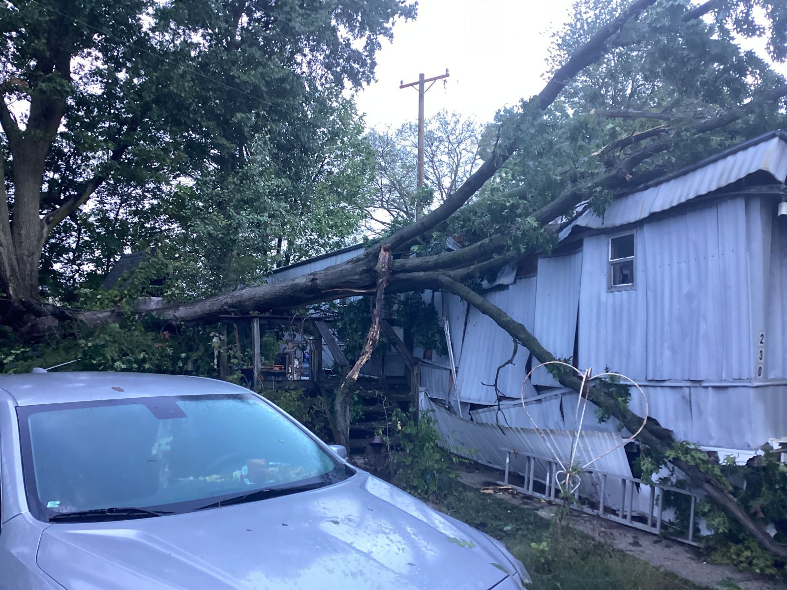 Tree down on mobile home |
Tornado and Straight-line Wind
|
Tornado - Cementville
|
||||||||||||||||
|
||||||||||||||||
|
Straight-Line Wind - Upton
|
||||||||||||||
|
||||||||||||||
The Enhanced Fujita (EF) Scale classifies tornadoes into the following categories:
| EF0 Weak 65-85 mph |
EF1 Moderate 86-110 mph |
EF2 Significant 111-135 mph |
EF3 Severe 136-165 mph |
EF4 Extreme 166-200 mph |
EF5 Catastrophic 200+ mph |
 |
|||||
Radar
.png) |
 |
 |
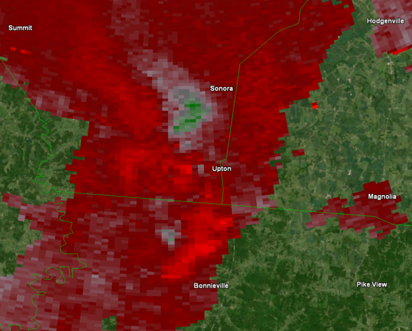 |
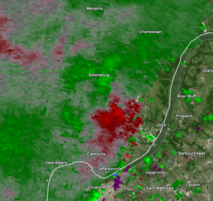
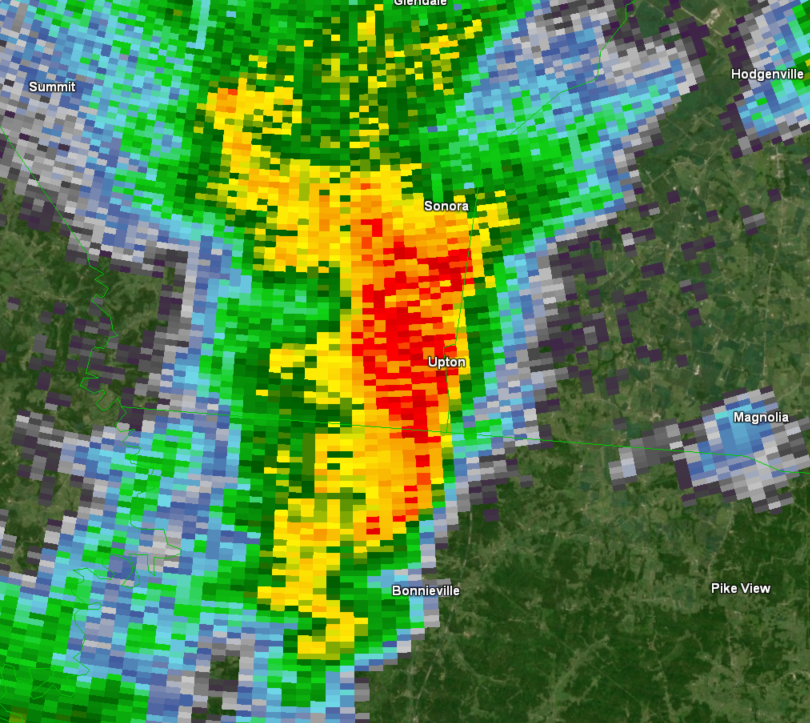
| Reflectivity over Clark County | Storm Relative Velocity over Clark County | Reflectivity over Hardin County | Storm Relative Velocity over Hardin County |
Storm Reports
..TIME... ...EVENT... ...CITY LOCATION... ...LAT.LON...
..DATE... ....MAG.... ..COUNTY LOCATION..ST.. ...SOURCE....
..REMARKS..
0130 PM Tstm Wnd Dmg Springfield 37.69N 85.22W
09/24/2024 Washington KY 911 Call Center
Corrects previous tstm wnd dmg report with
updated time from Springfield. Tree damage
and power lines down.
0132 PM Tstm Wnd Dmg 1 NNE Springfield 37.70N 85.22W
09/24/2024 Washington KY Public
A few large limbs and trees down in Idle
Hour Park. Structural damage to baseball
field.
0252 PM Tstm Wnd Dmg Campbellsville 37.35N 85.35W
09/24/2024 Taylor KY 911 Call Center
Few trees down within the city limits of
Campbellsville.
0153 PM Tstm Wnd Dmg 1 NE Prospect 38.36N 85.59W
09/24/2024 Oldham KY Public
A few trees down in River Bluff.
0154 PM Tstm Wnd Dmg 1 NNE Prospect 38.36N 85.60W
09/24/2024 Oldham KY Public
Tree on house at this location.
0220 PM Tstm Wnd Dmg 1 NE La Grange 38.41N 85.37W
09/24/2024 Oldham KY Public
Large tree limbs and a tree down near Maple
Avenue.
0432 PM Flood 1 NNE Tompkinsville 36.71N 85.69W
09/24/2024 Monroe KY 911 Call Center
Flooding in the main city.
0855 AM Tstm Wnd Dmg 3 E Buckeye 37.72N 84.45W
09/24/2024 Madison KY Trained Spotter
Uprooted tree at this location.
0400 PM Tstm Wnd Dmg Stanford 37.53N 84.66W
09/24/2024 Lincoln KY Public
A few large limbs and trees down in
Stanford.
1253 PM Tstm Wnd Dmg 2 S Hodgenville 37.54N 85.73W
09/24/2024 Larue KY 911 Call Center
2 trees down on Greensburg road.
1256 PM Tstm Wnd Dmg 1 E Hodgenville 37.56N 85.72W
09/24/2024 Larue KY 911 Call Center
Power pole wires damaged.
0336 PM Tstm Wnd Dmg Hodgenville 37.57N 85.74W
09/24/2024 Larue KY 911 Call Center
A few trees down in Hodgenville.
1233 PM Tstm Wnd Dmg 4 WSW Upton 37.44N 85.96W
09/24/2024 Hardin KY Emergency Mngr
Several large branches down across Brackett
Cemetery Road.
0519 PM Hail 1 NNW Cumberland City 36.82N 85.08W
09/24/2024 M1.25 Inch Clinton KY Public
Half dollar sized hail reported near
Cumberland City.
0525 PM Hail Cumberland City 36.80N 85.07W
09/24/2024 E1.75 Inch Clinton KY Trained Spotter
0255 PM Tstm Wnd Dmg 1 ESE Austin 36.81N 85.99W
09/24/2024 Barren KY 911 Call Center
Corrects previous tstm wnd dmg report time
from 1 ESE Austin. Tree down on Austin Tracy
Road.
0255 PM Tstm Wnd Dmg Lucas 36.89N 86.03W
09/24/2024 Barren KY 911 Call Center
Few trees down near Barren River Lake.
0250 PM Tstm Wnd Dmg 3 NNW Maynard 36.81N 86.11W
09/24/2024 Allen KY 911 Call Center
Trees down on JW York Road.
0306 PM Tstm Wnd Dmg Scottsville 36.75N 86.19W
09/24/2024 Allen KY Public
A few trees down in downtown Scottsville.
0310 PM Tstm Wnd Dmg 4 NW Maynard 36.80N 86.14W
09/24/2024 Allen KY 911 Call Center
Trees down near Old Glasgow Road.
0358 PM Hail Columbia 37.10N 85.31W
09/24/2024 M1.00 Inch Adair KY Trained Spotter
Ongoing at report time.
0118 PM Tstm Wnd Dmg 2 NW Floyds Knobs 38.34N 85.90W
09/24/2024 Floyd IN 911 Call Center
Power outage with traffic lights out at the
intersection of US150 and Paoli Pike.
0132 PM Tstm Wnd Dmg Floyds Knobs 38.32N 85.87W
09/24/2024 Floyd IN Public
A few trees down in Floyds Knobs.
0140 PM Tornado Cementville 38.35N 85.75W
09/24/2024 Clark IN NWS Storm Survey
NWS Storm Survey found a EF-0 tornado
touched down just NE of the I-65 and I-265
interchange. Sporadic tree damage, power
poles, and cross members were the main
damage. Trees were uprooted and topped,
hitting 2 different mobile homes. A railroad
arm at Apple Leaf Lane and US31 was bent
significantly along with a couple of trees
as it moved NE towards Charlestown Pike. The
tornado traveled 4 miles on the ground and
lifted just northeast of Charlestown Pike.
Peak winds were estimated at 80 mph and the
max path width was 100 yards.
0142 PM Tstm Wnd Dmg Cementville 38.35N 85.75W
09/24/2024 Clark IN Emergency Mngr
Tree on a house and power lines down at this
location.
0142 PM Hail 1 NE Sellersburg 38.40N 85.75W
09/24/2024 M0.75 Inch Clark IN Public
Dime sized hail reported in Sellersburg.
0143 PM Tstm Wnd Gst 1 SSE Hamburg 38.37N 85.76W
09/24/2024 E65 MPH Clark IN Public
Dime size hail, 60 to 65 mph winds, wall
cloud sighted.
0146 PM Tstm Wnd Dmg 1 N Watson 38.37N 85.70W
09/24/2024 Clark IN Public
A few trees down near Pine View Court.
Environment
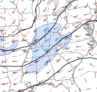
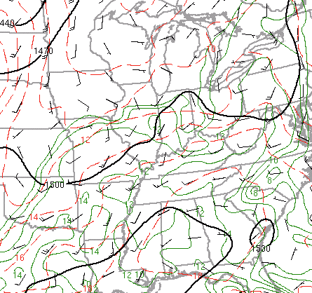
A trough was moving into the Ohio valley. Along with the trough, a surface cold front was moving into the region from the west. Central Kentucky and Southern Indiana were well within the warm sector of this system.
 |
 |
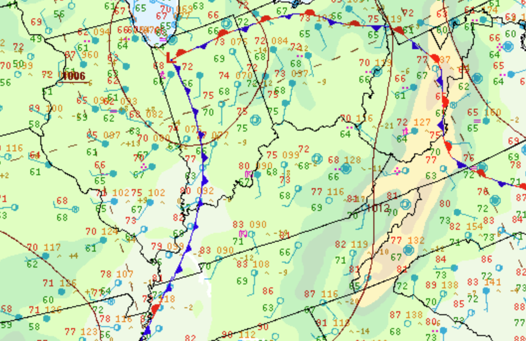 |
| Figure 1: 500mb Chart 18Z | Figure 2: 850mb Chart 18Z | Figure 3: Surface Chart 18Z |
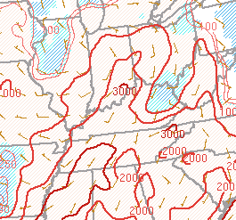
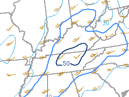
Scattered skies allowed for ample surface warming and increased surface based instability to develop in the early afternoon. Effective shear was 40-50kts within the region, plenty for organized storms to develop.
 |
 |
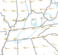 |
| Figure 4: SBCAPE / CIN 18Z | Figure 5: Effective Shear 18Z | Figure 6: 0-1km SRH 18Z |
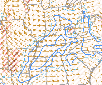
The Supercell Composite Parameter should a good signal for organized supercells to develop. Low LCLs around 600-750 meters was a good indicator that tornadoes would be possible.
 |
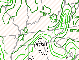 |
| Figure 7: Supercell Composite Parameter 18Z | Figure 8: LCL Heights 18Z |
 |
Media use of NWS Web News Stories is encouraged! Please acknowledge the NWS as the source of any news information accessed from this site. |
 |