
Severe thunderstorms will be possible from the central Plains to the Mid-Atlantic and Northeast on Monday. Hazardous heat will linger across the southern U.S. and build across the West through mid-week. Hot and dry conditions will fuel fire weather concerns for Interior Alaska and the Four Corners region through Monday. Read More >
McNeil, MS Tornado - April 19, 2020
|
Rating:
|
EF-1
|
|
Estimated Maximum Wind:
|
105 mph
|
|
Injuries/Fatalities:
|
None
|
|
Damage Path Length:
|
3.3 miles
|
|
Maximum Path Width:
|
200 yards
|
|
Approximate Start Point/Time:
|
3.4 miles NE of McNeil, MS at 951 PM
|
|
Approximate End Point/Time:
|
6.4 miles ESE of McNeil, MS at 958 PM
|
|
A National Weather Service Damage Assessment Team has surveyed the storm damage in Pearl River County near McNeil. It has been determined the damage was the result of a tornado. The tornado has been rated a EF-1 on the Enhanced Fujita Scale. Damage estimates were consistent with winds of 105 mph. The tornado began crossing Interstate 59 with one snapped softwood pine tree observed in the median of the interstate. The tornado continued southeast and likely continued to strengthen before crossing McNeil Steephollow Road, where there were several snapped hardwood and softwood trees, a few uprooted but did not observe any structual damage to homes. More damage was observed just to the south across the very end of Elmer Lee Road, with a damaged/uplifted or tipped over chicken coop, along with more softwood tree damage. The tornado continued southeast before crossing Bouie Road. A softwood pine tree was observed to be completley stripped of branches, with the top twisted off giving the tornado its likely peak maximum strength at 105 mph, along with several snapped and uprooted softwoods in the vicinity. Minor structual damage was observed nearby to a house with portion of a roof either damaged or missing. Survey continued southeast to Anner road, but did not observe any damage with the tornado likely lifting between Anner and Bouie Road. |
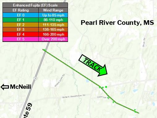
Surveyed damage track in Pearl River County, MS
|
|
||||||||||||||


