|
NOVEMBER 7 1957 |
|
PARISH |
TIME (CST) |
RATING |
PATH LENGTH |
PATH WIDTH |
DEATHS |
INJURIES |
DAMAGE |
| RAPIDES | 2104 | F3 | 3 miles | 75 yards | 2 | 28 | $500,000 |
 |
|||||||
|
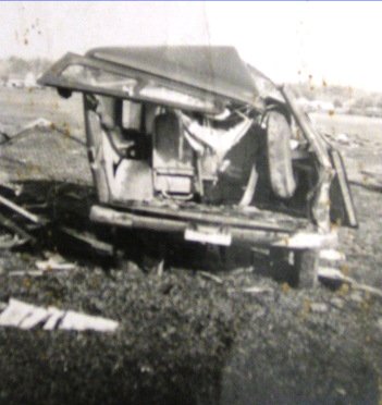
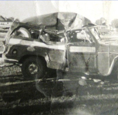
This strong tornado caused immense damage as it touched down in the middle of the city of Alexandria and moved through mainly residential sections on the south side of the downtown area. Touching down in the 2300 block of Hill Street, the tornado moved northeast, damaging or destroying numerous homes before crossing Lee Street and striking many businesses. The tornado continued into the Sonia Quarters and Lower Third sections of the city southeast of downtown, completely destroying many homes, killing 2 people, and injuring numerous others. Crossing the Red River, the tornado moved into Wardville, where it damaged or destroyed another nine homes and injuring a few more persons before lifting. In total, the Red Cross survey stated that 315 homes were damaged or destroyed in Alexandria by this tornado, with hundreds of others receiving minor damage. In addition, 28 injuries required hospitalization, while many other injuries did not require hospitalization. (Shamburger 2009) References: Alexandria Town Talk Note: This tornado is incorrectly listed in both NWS Storm Data and Significant Tornadoes by Tom Grazulis as being the same tornado that struck Boyce, LA, a few minutes earlier. |
|||||||
|
PARISH |
TIME (CST) |
RATING |
PATH LENGTH |
PATH WIDTH |
DEATHS |
INJURIES |
DAMAGE |
| RAPIDES | 2055 | F2 | 1 mile | 50 yards | 1 | 14 | $25,000 |
 |
|||||||
|
This tornado destroyed 11 homes and damaged several others in the Washington Court section of Boyce, northwest of Highway 1. One woman was killed as her home was blown off its foundation into a nearby home, with 14 other injuries. (Shamburger 2009) References: Alexandria Town Talk Note: This tornado is incorrectly listed in both NWS Storm Data and Significant Tornadoes by Tom Grazulis as being the same tornado that struck Alexandria, LA, a few minutes later. |
|||||||
|
COUNTY |
TIME (CST) |
RATING |
PATH LENGTH |
PATH WIDTH |
DEATHS |
INJURIES |
DAMAGE |
| JEFFERSON | 2015 | F2 | 5 miles | 50 yards | 0 | 0 | $14,000 |
 |
|||||||
|
Moved (east-north)east and destroyed three homes near Nome and China. (Grazulis 1993) This tornado destroyed a two-story home and damaged a Sun Oil Company pipe shed near Nome, and damaged two homes near China. (Shamburger 2009) References: Beaumont Enterprise Note: This tornado is incorrectly listed in both NWS Storm Data and Significant Tornadoes by Tom Grazulis as moving southeast. The damage locations show that the tornado moved east-northeast, consistent with all of the other tornadoes in the outbreak. |
|||||||
|
COUNTY |
TIME (CST) |
RATING |
PATH LENGTH |
PATH WIDTH |
DEATHS |
INJURIES |
DAMAGE |
||||
| JEFFERSON | 2115 | F3 | 3 miles | 150 yards | 2 | 53 | $2,300,000 | ||||
 |
|||||||||||
|
160 homes & businesses were destroyed, and 1000 other buildings were damaged in a 35-block area as the tornado moved east-northeast across Groves. A few small homes were leveled. Two men, both elderly, were killed in the destruction of separate small homes. Eleven injuries were serious. (Grazulis 1993) This tornado was the most damaging out of all the tornadoes in this outbreak. In 2007 dollars, this tornado caused around $17 million in damage, one of the worst tornadoes in the history of Southeast Texas. (Shamburger 2009) References: Beaumont Enterprise Note: This tornado is incorrectly listed in both NWS Storm Data and Significant Tornadoes by Tom Grazulis as occurring at 9:29 PM, due to an erroneous report by a police officer. Victims of the tornado clearly stated the tornado occurred around 9:15 PM. In addition, NWS Storm Data lists incorrect locations for the path of this tornado. Click here for a survivor account by Mrs. Carol Crain.
|
|||||||||||
|
PARISHES |
TIME (CST) |
RATING |
PATH LENGTH |
PATH WIDTH |
DEATHS |
INJURIES |
DAMAGE |
| ACADIA/ST LANDRY | 2330 | F3 | 8 miles | 200 yards | 4 | 15 | $500,000 |
 |
|||||||
|
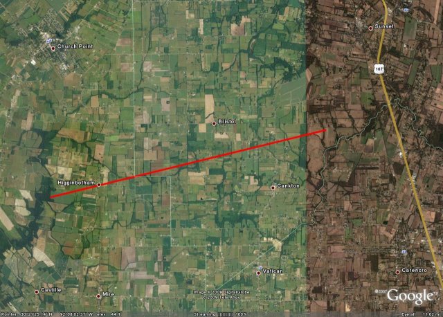
Moved east-northeast from 2 miles southwest of Higginbotham, through Higginbotham, to between Bristol and Cankton. Two people were killed near the start of the path when their home was blown apart and they were thrown 150 yards. Near the parish line, two people died in adjoining tenant homes. A total of 25 homes and 60 farm buildings were damaged or destroyed. (Grazulis 1993, Shamburger 2009) Note: A deadly tornado is incorrectly listed in NWS Storm Data as occurring near Carencro, LA, on this date - and is actually this tornado. No known tornado occurred in Carencro on 11/7/57. In addition, this tornado is incorrectly listed in Significant Tornadoes by Tom Grazulis as occurring at 2130 CST. Survivors clearly state the tornado occurred after 2300 CST. Click here for survivor accounts by Mr. Ed Meche and Ms. Juanita Meche. |
|||||||
|
PARISH |
TIME (CST) |
RATING |
PATH LENGTH |
PATH WIDTH |
DEATHS |
INJURIES |
DAMAGE |
| VERNON | 2035 | F2 | 1 mile | 50 yards | 0 | 0 | N/A |
 |
|||||||
|
One home was destroyed near Leesville. (Grazulis 1993) |
|||||||
|
COUNTY |
TIME (CST) |
RATING |
PATH LENGTH |
PATH WIDTH |
DEATHS |
INJURIES |
DAMAGE |
| ORANGE | 2127 | F4 | 6 miles | 200 yards | 1 | ~50 | $1,500,000 |
 |
|||||||
|
1 pregnant woman was killed at 2nd Street & John Street in Orange, and approximately 50 others injured as a tornado destroyed 180 homes and damaged 250 others in Orange. This was the fourth significant tornado (F2+) in Southeast Texas this evening, and appears to have been the most intense. About 115 of the destroyed homes were in the Riverside Housing Project. 9 ships and 3 barges were torn from their moorings, some of which were blown across the Sabine River onto the Louisiana side. (Grazulis 1993, Shamburger 2009) References: Orange Leader, Port Arthur News, Beaumont Enterprise Note: This tornado is incorrectly listed in both NWS Storm Data and Significant Tornadoes by Tom Grazulis as occurring at 11:27 PM. However, all media reports state the tornado occurred shortly before 9:30 PM. Also, injury reports vary wildly from 20 in the Orange Leader to 81 in the Beaumont Enterprise. The F4 rating is questionable as the quality of the housing in the area was poor, and F3 is likely a more accurate rating. Finally, reports in the Orange Leader suggest the tornado was dissipating into a downburst as it moved into the Riverside Housing Project. However, it is possible the tornado crossed into Louisiana before lifting. |
|||||||
|
COUNTY |
TIME (CST) |
RATING |
PATH LENGTH |
PATH WIDTH |
DEATHS |
INJURIES |
DAMAGE |
| JEFFERSON | 2110 | F2 | 1.5 miles | 70 yards | 0 | 1 | $75,000 |
 |
|||||||
|
5 homes were destroyed & 15 homes were damaged on the southeast side of Port Acres as this tornado moved east-northeast. (Grazulis 1993, NWS Storm Data) Note: The official time for this tornado is incorrectly listed in both NWS Storm Data and Significant Tornadoes by Tom Grazulis as occurring at 9:23 PM. News accounts indicate the tornado occurred around 910 PM. |
|||||||