January 25 Severe Weather Outbreak
On the morning of January 25, 2012, a slow moving cold front pushed through Southeast Texas and Southwest Louisiana. Ahead of this front, a strong squall line developed and by midday began producing embedded tornados as it pushed across the area. A Tornado Watch was issued by the Storm Prediction Center at 7:55 AM for the entire area through 3:00 PM on the afternoon of the 25th. The watch was eventually reissued through 9:00 PM.

A total of 12 tornados were confirmed over the course of the afternoon and evening. Additionally, another 4 reports of severe thunderstorm damage as well as 7 reports of strong marine winds were reported over the course of the event.

A total of 32 warnings were issued during the event. These warnings consisted of 9 Tornado warnings, 13 Severe Thunderstorm Warnings and 10 Special Marine Warnings.

The details of the individual tornados as well as Severe Thunderstorm and Marine reports are outlined below.
Tornados
Wildwood, TX

January 25, 2012 12:03 PM 0.5 Reflectivity KLCH

A Tornado Warning was issued at 12:05 PM for Northern Hardin as well as Southern and Central Tyler County
NWS Storm Survey
Date: 1/25/2011
Time: 12:05 PM
Event: Tornado
Rating: EF 0 (65–85 MPH)
Location: 4 Miles South of Wildwood (Hardin County)
Injuries: 0
Fatalities: 0
Several trees were blown down or snapped along sections of Post Oak Rd...Extending over highway 69. The path length was three miles and the width was 20 yards.

Tornado path 4 South Wildwood
Caney Head, TX

January 25, 2012 12:30 PM 0.5 Reflectivity KLCH

A Tornado Warning was issued at 12:29 PM for Eastern portions of Tyler County and Western portions of Jasper County
NWS Storm Survey
Date: 1/25/2011
Time: 12:30 PM
Event: Tornado
Rating: EF 0 (65–85 MPH)
Location: 3 Miles North Northwest of Caney Head (Tyler County)
Injuries: 0
Fatalities: 0
A couple miles south of Fred, several trees were blown down, a carport was damaged and a shed lost some tin from its roof. The tornado path was 0.4 miles long and its width was 10 yards.

Tornado Path 3 Miles North Northwest of Caney Head
Call, TX

January 25, 2012 12:58 PM 0.5 Reflectivity KLCH

A Tornado Warning was issued at 12:59 for East Central Jasper and West Central Newton Counties.
NWS Storm Survey
Date: 1/25/2011
Time: 1:00 PM
Event: Tornado
Rating: EF 1 (86–110 MPH)
Location: 4 Miles Northwest of Call (Jasper County)
Injuries: 0
Fatalities: 0
A tornado touched down near the Kirbyville Airport, where it tore part of a metal roof off a home. It then moved into Western sections of Kirbyville blowing trees down and damaging a shed. The tornado was on the ground for 1.6 miles and was 20 yards wide.
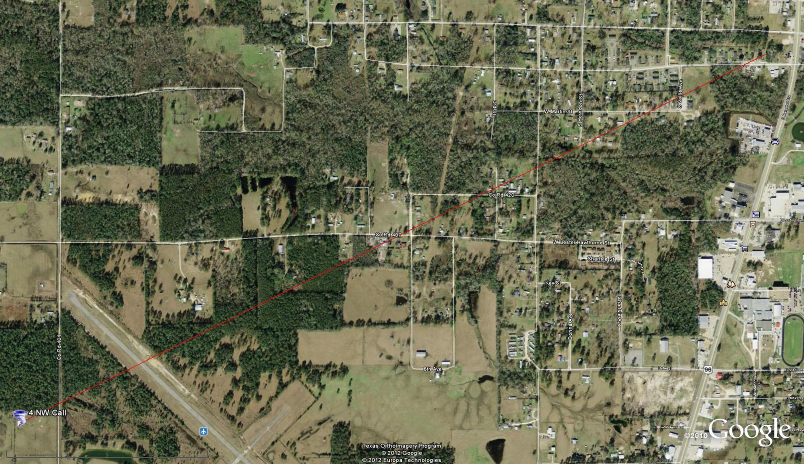
Tornado path 4 miles Northwest of Call
Magnolia Springs, TX

January 25, 2012 1:02 PM 0.5 Reflectivity KLCH

A tornado warning was issued at 12:59 PM for East Central Jasper and West Central Newton counties
NWS Storm Survey
Date: 1/25/2011
Time: 1:02 PM
Event: Tornado
Rating: EF 0 (65–85 MPH)
Location: 1 Mile North Northeast of Magnolia Springs (Jasper County)
Injuries: 0
Fatalities: 0
A tornado touched down along FM 1005 blowing some trees down. It was on the ground for 0.8 miles and its width was 10 yards.

Tornado path 1 Mile Northeast of Magnolia Springs
Toledo Bend Dam, LA

January 25, 2012 1:34 PM 0.5 Reflectivity KPOE

A Tornado Warning was issued at 1:29 PM for Eastern portions of Newton County as well as West Central Beauregard and Western Vernon parishes
NWS Storm Survey
Date: 1/25/2011
Time: 1:35 PM
Event: Tornado
Rating: EF 0 (65–85 MPH)
Location: 5 Miles South Southeast of Toledo Bend Dam (Vernon Parish)
Injuries: 0
Fatalities: 0
An EF 0 tornado touched down on Lynn Nash Road blowing over and snapping trees along a three mile path that crossed LA Highway 111. Path Width was 20 yards.

Tornado path 5 Miles South Southeast of Toledo Bend Dam
Fort Polk, LA

January 25, 2012 2:28 PM 0.5 Reflectivity KPOE

A Tornado Warning was issued at 2:01 PM for much of Bearegard and Vernon parishes.
NWS Storm Survey
Date: 1/25/2011
Time: 2:30 PM
Event: Tornado
Rating: EF 0 (65–85 MPH)
Location: 3 Miles South Southeast of Fort Polk (Vernon Parish)
Injuries: 0
Fatalities: 0
EF 0 tornado touched down in the middle of the woods near Fort Polk. The tornado crossed LA Highway 10. Many pine trees were snapped or blown down. Path length was one mile and path width was 20 yards.
.jpg)
Funnel Cloud near Ft Polk at 2:41 PM. Courtesy: KPLC TV

Tornado path 3 miles South Southeast of Fort Polk
Hineston, LA
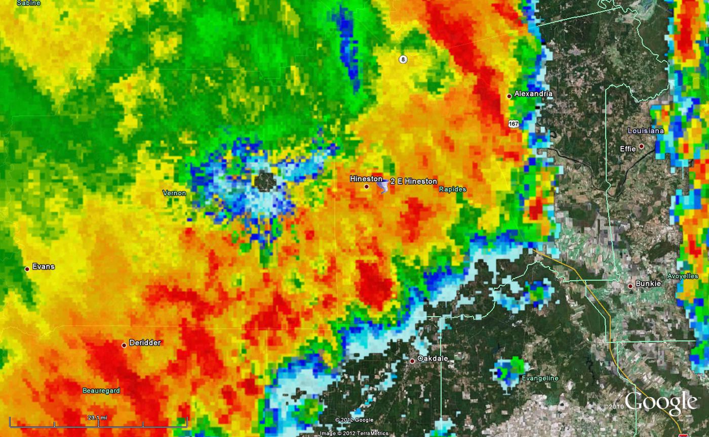
January 25, 2012 3:37 PM 0.5 Reflectivity KPOE

A Tornado Warning was issued at 2:56 PM for Western portions of Rapides parish
NWS Storm Survey
Date: 1/25/2011
Time: 3:35 PM
Event: Tornado
Rating: EF 0 (65–85 MPH)
Location: 2 Miles East of Hineston (Rapides Parish)
Injuries: 0
Fatalities: 0
EF 0 tornado touched down near Harper Road before crossing LA Highway 112 and dissipating along Twin Bridges Road. Several trees were blown down or snapped in half. One of these trees damaged a patio. Path length was 1.5 miles and path width was 20 yards.

Tornado path 2 miles East of Hineston
Kolin, LA

January 25, 2012 1:34 PM 0.5 Reflectivity KPOE

A Tornado Warning was issued at 3:24 PM for much of Rapides Parish.
NWS Storm Survey
Date: 1/25/2011
Time: 4:06 PM
Event: Tornado
Rating: EF 0 (65–85 MPH)
Location: 1 Mile Southwest of Kolin (Rapides Parish)
Injuries: 0
Fatalities: 0
An EF 0 tornado touched down along Palmer Chapel road blowing several trees down. It dissipated near the Ruby-Wise school on LA Hwy 107 where it damaged part of a roof at the school. Path length was 1.5 miles and path width was 20 yards.

Tornado path 1 Mile Southwest of Kolin
Sulphur/Westlake, LA

A Severe Thunderstorm Warning was issued for portions of Western Cameron, Calcasieu and Eastern Beauregard parishes
NWS Storm Survey
Date: 1/25/2011
Time: 4:45 PM
Event: Tornado
Rating: EF 1 (86–110 MPH)
Location: 3 Miles Northeast of Sulphur (Calcasieu Parish)
Injuries: 0
Fatalities: 0
Along Evergreen street between Sulphur and Westlake, a tornado touched down blowing trees down and damaging several homes when trees fell on the roof. This storm continued to the Northeast and hit several mobile homes near the golf course in Westlake before it moved into Moss Bluff where it ripped shingles off a couple of homes, destroyed a storage building, blew a fence down and knocked down some trees. This tornado was on the ground for 5.7 miles and was 25 yards wide.

Tornado Path 3 Miles Northeast of Sulphur
Damage Images

Photo Courtesy Anne Leone-Hixson
.jpg)
Photo Courtesy Jackie LeDoux Trouard

Photo Courtesy Briana Duplichan
Boyce, LA

January 25, 2012 3:14 PM 0.5 Reflectivity KPOE

A Tornado Warning was issued at 2:28 PM for Eastern Vernon and Western Rapides parishes
NWS Storm Survey
Date: 1/25/2011
Time: 3:13 PM
Event: Tornado
Rating: EF 0 (65–85 MPH)
Location: 5 Miles Southwest of Boyce (Vernon Parish)
Injuries: 0
Fatalities: 0
EF 0 tornado touched down near Cotile Lake on Vanzant and Bath House Roads before dissipating near LA Highway 1200. Many trees were blown down or snapped in half. Path length was 0.8 miles and path width was 20 yards.

Tornado Path 5 Miles Southwest of Boyce
Grand Chenier, LA
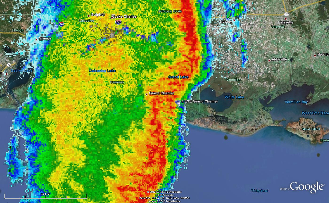
January 25, 2012 6:19 PM 0.5 Reflectivity KLCH

A Severe Thunderstorm Warning was issued at 5:53 PM for Eastern Cameron, East Calcasieu, Jeff Davis and Western Acadia Parishes
NWS Storm Survey
Date: 1/25/2011
Time: 6:21 PM
Event: Tornado
Rating: EF 0 (65–85 MPH)
Location: 4.1 Miles East Southeast of Grand Chenier Airport (Cameron Parish)
Injuries: 0
Fatalities: 0
A home lost its carport and part of its roof when a tornado moved across highway 82 near Grand Chenier. Debris was blown into the marsh behind the house.

Tornado Path 4.1 Miles East Southeast of Grand Chenier Airport
Duson, LA

January 25, 2012 7:56 PM 0.5 Reflectivity KLCH

A Severe Thunderstorm Warning was issued at 7:19 PM for much of Lafayette, St Martin and St Landry parishes
NWS Storm Survey
Date: 1/25/2011
Time: 7:58 PM
Event: Tornado
Rating: EF 0 (65–85 MPH)
Location: 2.3 Miles East of Duson (Lafayette Parish)
Injuries: 0
Fatalities: 0
A small tornado touched down in the 100 block of La Rue Rhiems where a mobile home lost most of its roof. Another mobile home in the 200 block of La Rue Biarritz had major damage to its porch and carport. Debris was scattered in fields and trees nearby.

Tornado path 2.3 miles East of Duson
Severe Thunderstorm Reports
Several reports of wind damage were received throughout the day as well. Some of these were later determined to be tornado damage while others were straight line winds associated with strong thunderstorms. These straight line wind damage reports as well as the only hail report received on the 25th are outlined below.
1. 12:35 PM - A HAM radio operator relayed a report via Facebook of quarter (1.00 inch) size hail near Jasper, TX.
2. 3:35 PM - Rapides parish sheriff reports trees down on Moss Point Drive and LA Highway 1N.
3. 3:47 PM - Rapides parish sheriff reports a tree down on a house in the 6100 block of Mcray Drive in the Ball community.
4. 4:30 PM - Rapides parish sheriff reports a tree down on a garage and vehicle two miles south of Deville.
Marine Reports
In addition to the tornado and severe thunderstorm reports received, the National Weather Service also issued 10 Special Marine Warnings for the possibility of strong winds over the lakes and offshore waters. Seven such reports were received over the course of the event which are outlined below.

1. 3:30 PM - Platform in West Cameron block 53 reports an estimated wind speed of 55 MPH.
2. 3:42 PM - Platform in West Cameron block 17 reports an estimated wind speed of 45 MPH.
3. 4:35 PM - Platform in West Cameron block 130 reports an estimated wind speed of 45 MPH.
4. 5:18 PM - C-MAN station CAPL1 reports a measured wind speed of 45 MPH.
5. 6:20 PM - AWOS station KCMB reports a measured wind speed of 46 MPH.
6. 8:00 PM - Platform in Vermilion block 24 reports an estimated wind speed of 55 MPH.
7. 8:15 PM - AWOS station KVNP reports a measured wind speed of of 51 MPH.
Webpage Created by Donald Jones

