National Weather Service United States Department of Commerce
Tropical Storm Alberto
June 17-20, 2024

GOES 16 Infrared Satellite Image of Tropical Storm Alberto across the Western Gulf of Mexico at 1:01 PM CDT June 19, 2024.
Above: GOES 16 GeoColor Satellite Image of Tropical Storm Alberto across the Western Gulf of Mexico at 1:01 PM CDT June 19, 2024.

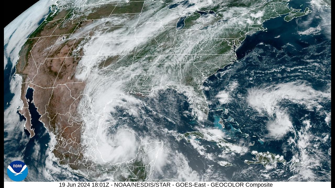
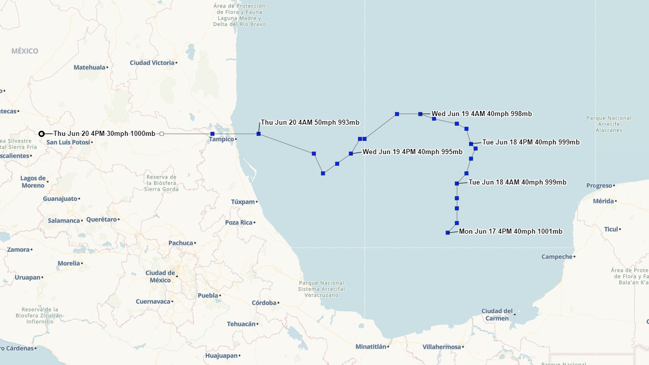
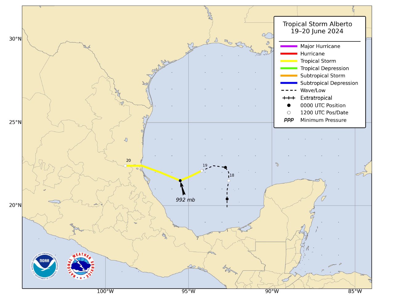
A large broad area of low pressure formed across the Bay of Campeche on June 17th. This large area of low pressure, coupled with a large surface high pressure over the Eastern United States, created a tight pressure gradient across the Northern Gulf of Mexico, resulting in a large easterly wind fetch over this region.  The broad low-pressure area drifted northward through the evening of June 18th in response of a mid to upper-level trough of low pressure across Texas and Northern Mexico. By June 19th, the mid to upper-level trough lifted northward with a mid to upper-level high pressure ridge building westward across the Southern U.S. This allowed for the broad area of low pressure to turn westward and gradually get better organized, being upgraded to Tropical Storm Alberto at 10 AM CDT June 19th. Tropical Storm Alberto gradually strengthened further and made landfall around Tampico, Mexico just before daybreak June 20th with maximum sustained winds of 50 mph (45 knots).  Alberto continued to move quickly westward after landfall, dissipating across the mountains of Central Mexico later that afternoon.

WINDS & PRESSURE:
No sustained tropical storm force winds occurred across Southeast Texas, Central or Southern Louisiana. Highest sustained winds of 25 to 30 mph gusts of 40 to 45 mph occurred with the passing squalls.  For complete wind and pressure reports, see the Winds and Pressure section of the Post Tropical Cyclone Report.

WATER LEVELS:
The large and prolonged easterly winds across the Northern Gulf of Mexico resulted in water levels around 2.5 to 3.0 feet MHHW along Lower Jefferson County across Southeast Texas, Cameron and Lower Vermilion Parishes across Southwest Louisiana. Further inland across Southern Orange County, Southern Calcasieu Parish, as well as Lower Iberia and Lower St. Mary Parishes across South Central Louisiana, water levels of 2.0 to 2.5 feet MHHW were recorded. This caused minor to moderate coastal flooding. Due to the prolonged duration of higher tides, salt water intrusion into most of the low lying and marsh areas of the counties and parishes affected took a few days to drain out once the easterly winds had receded.  For complete water levels reports, see the Water Levels section of the Post Tropical Cyclone Report.

RAINFALL:
Rainfall of one inch or less was common across most locations. A few higher amounts of two to over 4 inches were recorded along and south of the I-10 corridor, with the highest total of 4.69 recorded at Catfish point, Louisiana.  For complete storm total rainfall, see the Rainfall section of the Post Tropical Cyclone Report.

TORNADOES:
No tornadoes were reported.

Hurrevac track of Tropical Storm Alberto from operational National Hurricane Center public advisories.
Above: Hurrevac track of Tropical Storm Alberto from operational National Hurricane Center public advisories.

Radar and Satellite Animated Imagery
(NWS LCH YouTube)
Radar Imagery: Brownsville, TX    
GOES 16 Satellite Imagery: 4km Infrared 4km Visible 4km GeoColor
2km Infrared 1km Visible 1km GeoColor


Post Tropical Cyclone Reports
Brownsville, TX Corpus Christi, TX Houston, TX
National Hurricane Center  


Webpage design by: Donovan Landreneau
Content by: NWS Lake Charles staff, other sources as noted above.