|
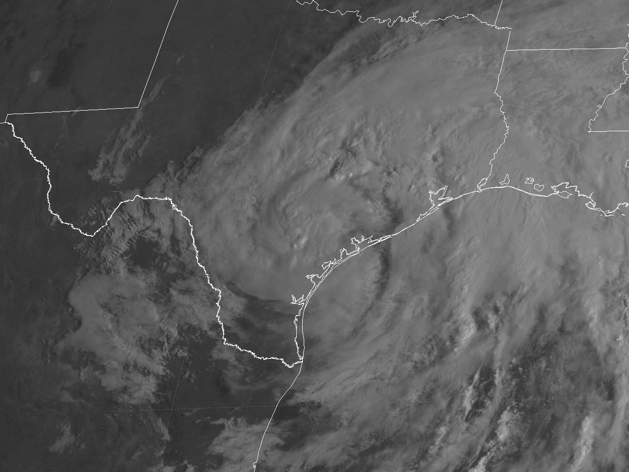
Above: GOES-8 visible satellite image of Tropical Storm Frances just after landfall across the Central Texas coast at 9:02 AM CDT September 11, 1998.
On September 4th, a large broad area of low pressure showed signs of organization across the Western Caribbean Sea and Southern Gulf. This area of low pressure gradually increased in organization, and by the afternoon of September 8th, advisories were initiated on Tropical Depression #6 centered around 220 miles southeast of Corpus Christi, Texas. With a strong mid to upper-level ridge extending across the Central United States, the system drifted erratically southward through the afternoon of September 9th, when it strengthened into Tropical Storm Frances.
Tropical Storm Frances began to move northward the evening of September 9th through September 11th as the mid to upper-level ridge now extended from the Central to Southeast United States. Frances slowly strengthened and grew in size across the Northwest Gulf, with the width of tropical storm force winds over 450 miles by the evening of September 10th when the storm reached its peak wind intensity of 65 mph (55 knots).
Tropical Storm Frances winds weakened somewhat but remained a very large tropical storm as the central pressure continued to fall before making landfall just north of Corpus Christi, Texas around 1:00 AM CDT September 11th with maximum sustained winds of 45 mph (40 knots) and a minimum central pressure of 990 millibars (29.23 inches). After landfall, the center made a small cyclonic loop for 12 hours between Corpus Christi and Victoria, and resumed a northward motion between San Antonio and Houston that afternoon, weakening to a tropical depression by that evening. The northward motion of Frances slowed to a crawl on September 12-13th between College Station and Dallas, with the center finally dissipating across the Dallas & Fort Worth Metroplex the afternoon of September 13th. Click here for an interactive track of Tropical Storm Frances.
WIND & PRESSURE:
Sustained winds of tropical storm force occurred across Southeast Texas mainly along and south of I-10. The highest sustained winds of 49 mph (43 knots) with a peak wind gust of 66 mph (57 knots) were recorded at Sea Rim State Park along coastal Jefferson County Texas at 6:30 AM CDT September 11th. Elsewhere, maximum sustained winds of 20 to 30 mph with peak gusts of 30 to 40 mph were recorded across the remainder of Southeast Texas, Central and Southern Louisiana within the passing rainbands. For complete meteorological statistics, see the Wind and Pressure section.
STORM SURGE:
Due to the very large tropical storm force wind field for several days, significant storm surge flooding and beach erosion occurred across coastal Jefferson County in Southeast Texas, and coastal Cameron Parish in Southwest Louisiana, with highest tides of 5.0 to 5.5 feet MSL during this period. Highway 87 across coastal Jefferson County, and Highway 82 across coastal Cameron Parish were closed off and on from September 10th through the 13th with as much as 3 feet deep in some places. Many homes and businesses in Sabine Pass, Texas has some damage due to flooding. Several camps in Constance Beach, Louisiana were destroyed or heavily damaged due to erosion and high tides. Most roads in Holly Beach, Cameron, Creole, and Grand Chenier had flooding. Officials and residents described the extent of coastal flooding across Coastal Jefferson County and Coastal Cameron Parish as the worst since Hurricane Carla in 1961. For other storm surge and high-water marks, see the Storm Surge section.
RAINFALL:
Due to the very large envelop of moisture and slow movement of Tropical Storm Frances, bands of heavy rainfall continued from September 7th through the 14th, depositing 10 to more than 15 inches of rainfall across Southeast Texas, Central and Southern Louisiana. The highest storm total rainfall across our region was 19.24 inches measured at a cooperative observer in Boyce, Louisiana. Further east, an even higher total of 22.39 inches was measured in Terrytown, Louisiana. For complete rainfall totals reported across our region, see the Rainfall section.
TORNADOES:
Tropical Storm Frances produced a significant tornado outbreak September 11-12th across Central and Southern Louisiana with a total of 10 tornadoes ranging from F0 to F1 in intensity. The two tornadoes in Midland and Basile, Louisiana accounted for seven million in damages, five injuries, and fortunately no fatalities. For complete details on the tornadoes reported across Texas and Louisiana, see the Tornadoes section. For more detailed information on the tornadoes that occurred across Central and Southwest Louisiana, see Tropical Storm Frances Tornado Outbreak: September 11-12, 1998.
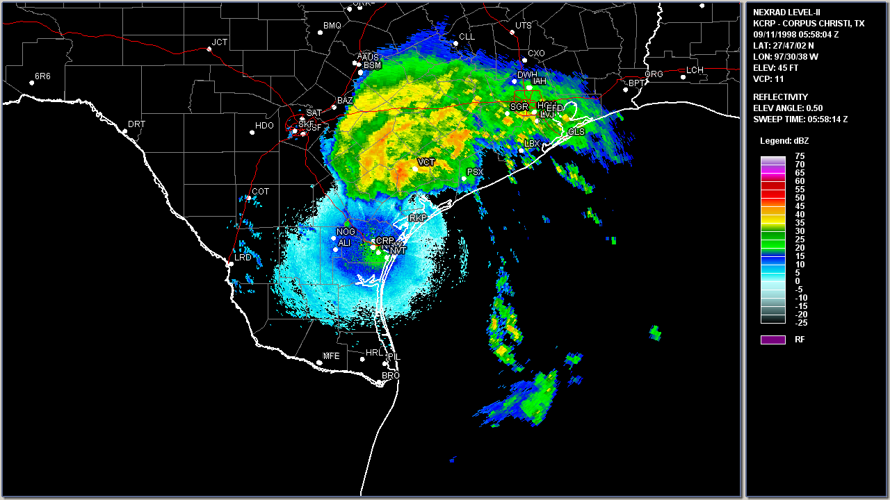
Above: Corpus Christi, TX WSR-88D radar image of Tropical Storm Frances making landfall just north of Corpus Christi, Texas 12:58 AM CDT September 11, 1998.
|

