Lake Charles, LA
Weather Forecast Office
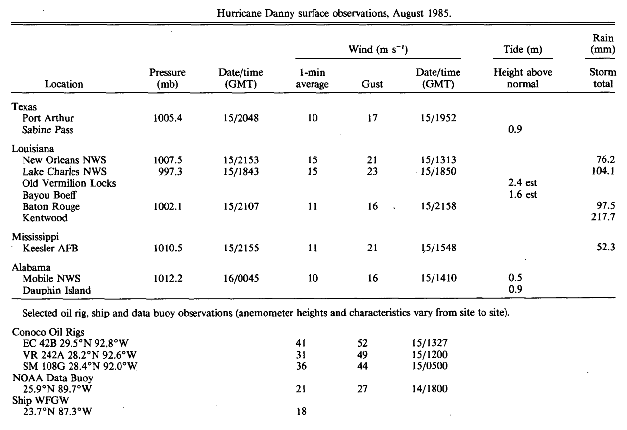
| Hurricane Danny | ||
| August 11-20, 1985 | ||
|
|
||
|
Danny Storm Surge: Measured and High Water Marks |
||||
| Location | Feet (NGVD) | |||
| Matagorda, TX | (E) 2.2 (MSL) | |||
| Freeport, TX | (E) 2.5 (MSL) | |||
| Sabine Pass, TX | 3.0 (MSL) | |||
| Cameron, LA | 3.6 (MSL) | |||
| Grand Chenier, LA | 3.1 | |||
| Schooner Bayou Control Structure, LA | 5.8 | |||
| Freshwater Bayou Lock , LA | (I) 6.7 | |||
| Vermilion Lock (West) , LA | 2.6 | |||
| Vermilion Lock (East), LA | 7.1 | |||
| Old Vermilion Locks, LA | 7.9 (MSL) | |||
| Vermilion River at Bancker, LA | 5.8 | |||
| Lukes Landing, LA | (I) 7.7 | |||
| Calumet, LA | 6.1 | |||
| Atchafalaya Bay, Eugene Island, LA | 6.7 | |||
| Morgan City, Bayou Boeff, LA | 5.3 (MSL) | |||
| Sweet Bay Lake, LA | 5.8 | |||
| Round Bayou at Deer Island, LA | 6.2 | |||
| Bayou Petit Caillou at Cocodrie, LA | 5.3 | |||
| Bayou Lafourche at Leeville, LA | 3.8 | |||
| Grand Isle, LA | 3.8 | |||
| Venice, LA | 3.9 | |||
| Southwest Pass, LA | 4.0 | |||
| Head of Passes, LA | 2.8 | |||
| Port Eads, LA | 3.0 | |||
| Lake Borgne at Rigolets, LA | 4.1 | |||
| West End of Dauphin Island, AL | 3.0 (MSL) | |||
| Mouth of Mobile River, AL | 2.6 (MSL) | |||
| (E)=Estimated (I) =Incomplete |
||||
Forecasts
Marine Forecasts
Local Products
Model Data
Forecaster's Discussion
Fire Weather
Graphical Forecasts
Wet Bulb Globe Temps
Aviation Weather
Activity Planner
Mardi Gras Decision Support
Other Links
National Hurricane Ctr
Storm Prediction Ctr
Weather Prediction Ctr
Other Links
Office History
LCH StoryMap
Hazards
Severe Weather
Tropical Weather
National Outlooks
Local Storm Reports
Tropical Cyclone Reports
Current
Tide Data
Satellite Data
Observations
Hydrology
Jefferson Co. DD6 Network
River/Lake Forecasts
Calcasieu Par. Network
Radar
Shreveport (SHV)
New Orleans (LIX)
Fort Polk (POE)
Houston/Galveston (HGX)
Lake Charles (LCH)
Probabilistic Pages
Probabilistic Rainfall
Probabilistic DSS
Probabilistic Snowfall
US Dept of Commerce
National Oceanic and Atmospheric Administration
National Weather Service
Lake Charles, LA
500 Airport Boulevard
Lake Charles, LA 70607
(337) 477-5285 M-F 8a to 4p only
Comments? Questions? Please Contact Us.

