|
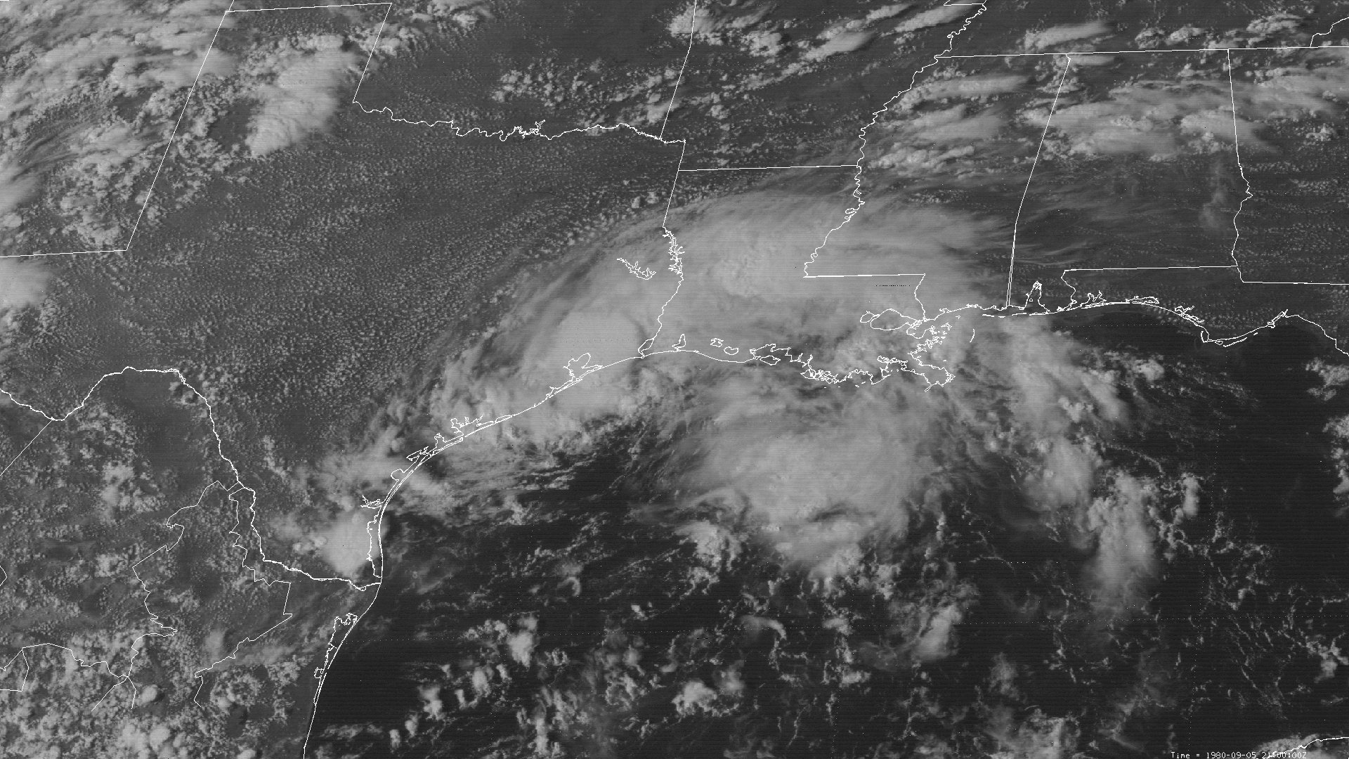
Above: SMS-2 visible satellite image of Tropical Storm Danielle at 4:00 PM CDT September 5, 1980, shortly before landfall across Galveston, TX.
Tropical Storm Danielle partially originated from a tropical wave that emerged off the African Coast on August 22nd and briefly became Tropical Depression #6 on August 25th. The depression traveled west through August 27th and turned to the northwest before degenerating back to a weak tropical wave on August 29th. The wave continued westward and eventually interacted with a mid-tropospheric low over Florida on September 2nd upon entering the Eastern Gulf.
A mid to upper level ridge over the Central and Eastern U.S. which had been a dominating feature for most of the summer steered the disturbance westward. By the afternoon of September 4th, the disturbance gradually organized and became Tropical Depression #9 about 60 miles south southwest of Grand Isle, Louisiana. The depression tracked west northwest and changed little in organization. By late morning on September 5th located 30 miles south of Cameron in Southwest Louisiana, oil rigs confirmed the depression had strengthened into Tropical Storm Danielle with sustained winds of 60 mph (50 knots). Little change in strength occurred as Danielle headed due west, making landfall in Galveston, Texas at 6:30 PM CDT.
Danielle continued to move a little south of due west after landfall, weakening to a depression by daybreak September 6th just north of Victoria, Texas, and dissipated across Central Texas on September 7th. Click here for an interactive track of Tropical Storm Danielle.
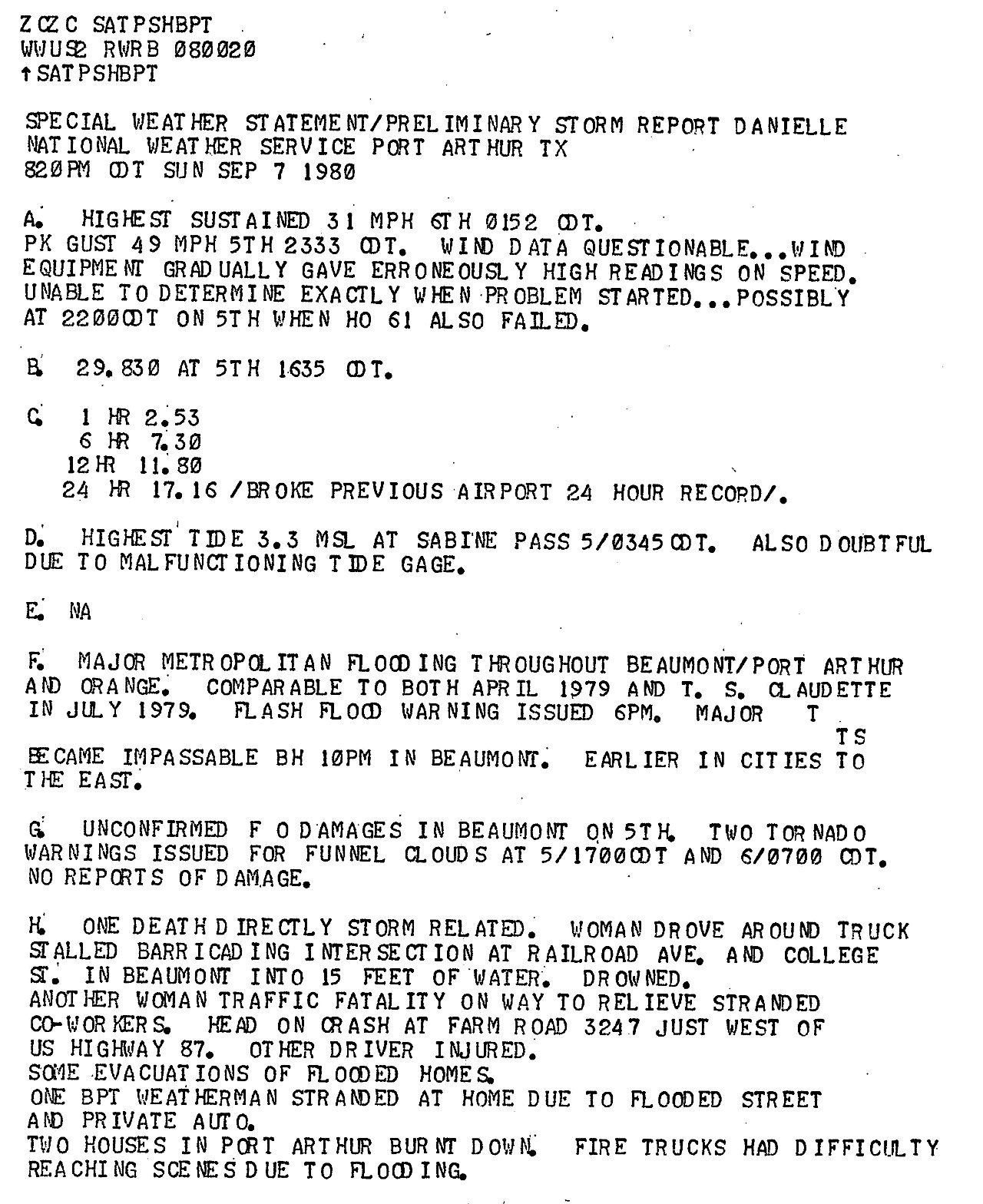
The main impact from Danielle was major flooding across Beaumont, Bridge City, Orange, Vidor, and Port Arthur Texas due to the 12 to 18 inches of rainfall that occurred, most of this in less than 24 hours. Flooding of many streets, homes, and businesses occurred in this area.
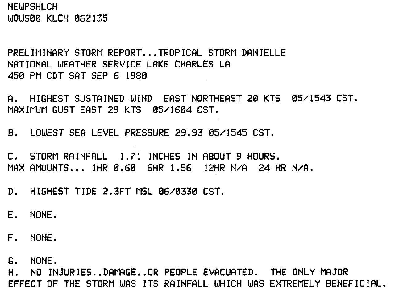
WIND & PRESSURE:
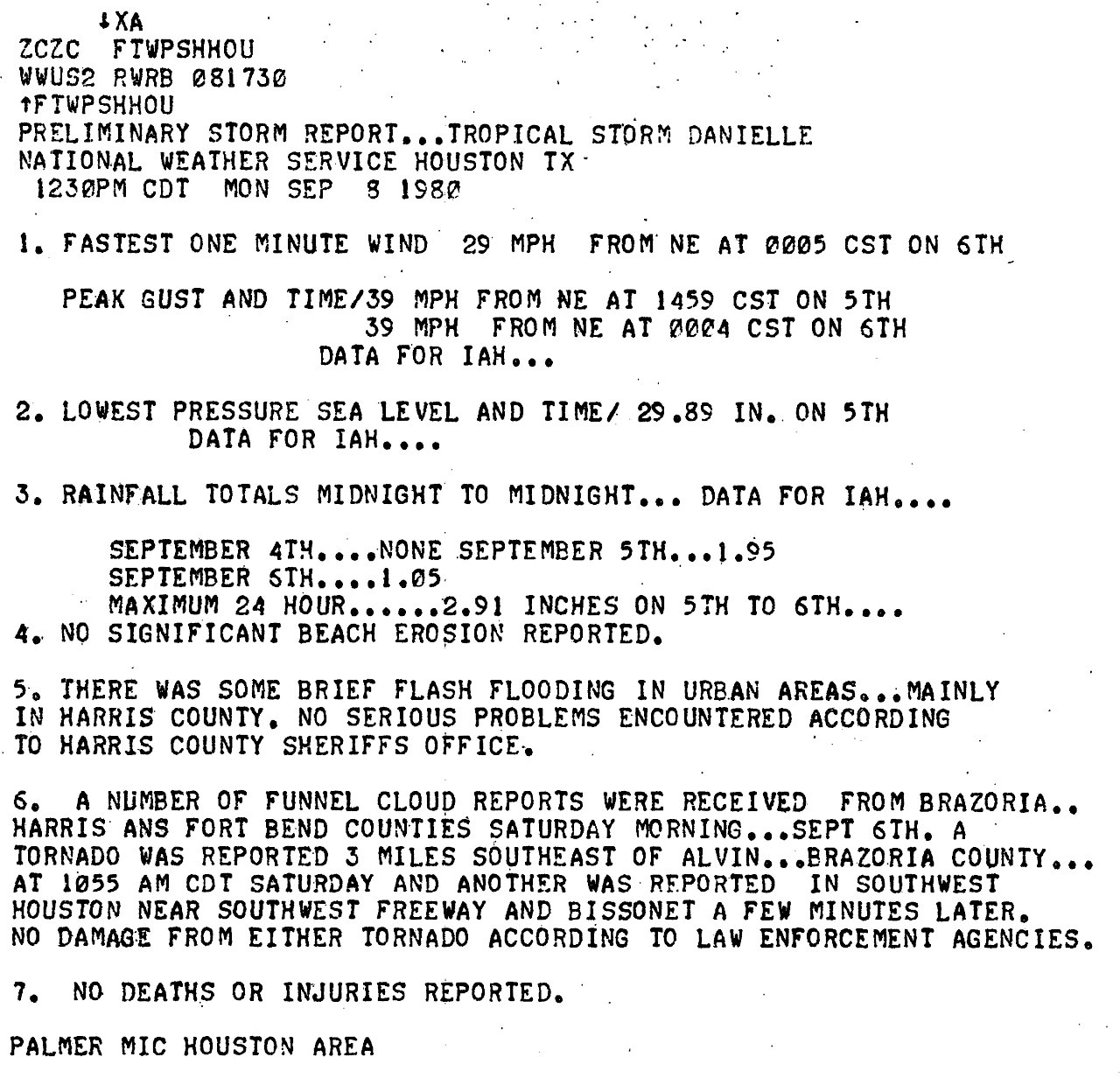
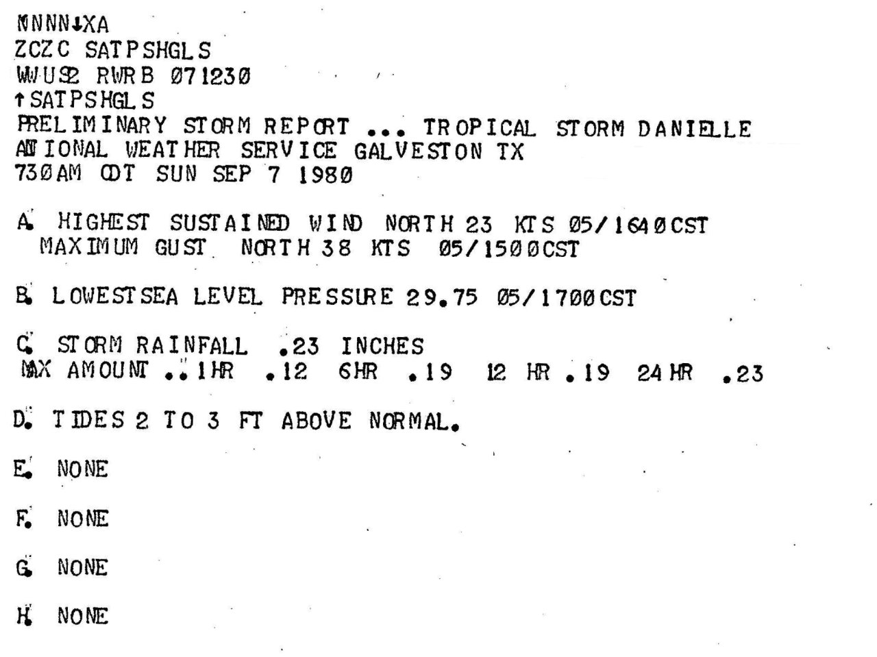
The National Weather Service in Port Arthur, Texas recorded a peak wind gust of 49 mph (43 knots) at 11:33 PM CDT September 5th. Elsewhere across Central and Southern Louisiana, maximum sustained winds of 20 to 25 mph with gust of 30 to 35 mph occurred. For complete meteorological statistics, see the Wind and Pressure section.
STORM SURGE:
Cameron, Louisiana recorded a maximum tide of 2.3 feet MSL, with Sabine Pass, Texas recording a maximum tide of 3.3 feet MSL. Only minor coastal flooding occurred with little beach erosion recorded. For other storm surge and high-water marks, see the Storm Surge section.
RAINFALL:
Storm total rainfall amounts of 12 to 18 inches occurred just north of the track across Southeast Texas along and south of I-10. The highest storm total rainfall of 18.29 inches was recorded at the National Weather Service in Port Arthur (Nederland) Texas, with 13.24 inches reported in Beaumont, Texas. Most of this rainfall occurred from the afternoon of September 5th into the early morning hours of September 6th after landfall. Elsewhere across our region, 2 to 5 inches was recorded across the remainder of Southeast Texas and Southwest Louisiana, with less than 2 inches recorded across the remainder of Central and South-Central Louisiana. For complete rainfall totals reported across our region, see the Rainfall section.
TORNADOES:
Several tornadoes occurred across Southeast Texas. An F1 tornado in Beaumont at 5:45 PM CDT September 5th and an F2 tornado in Nederland at 5:00 AM CDT September 6th caused a little more than a quarter of a million dollars in damage. Fortunately, no deaths or injuries were reported. For complete details on all the tornadoes reported across Texas, see the Tornadoes section.
|

