|
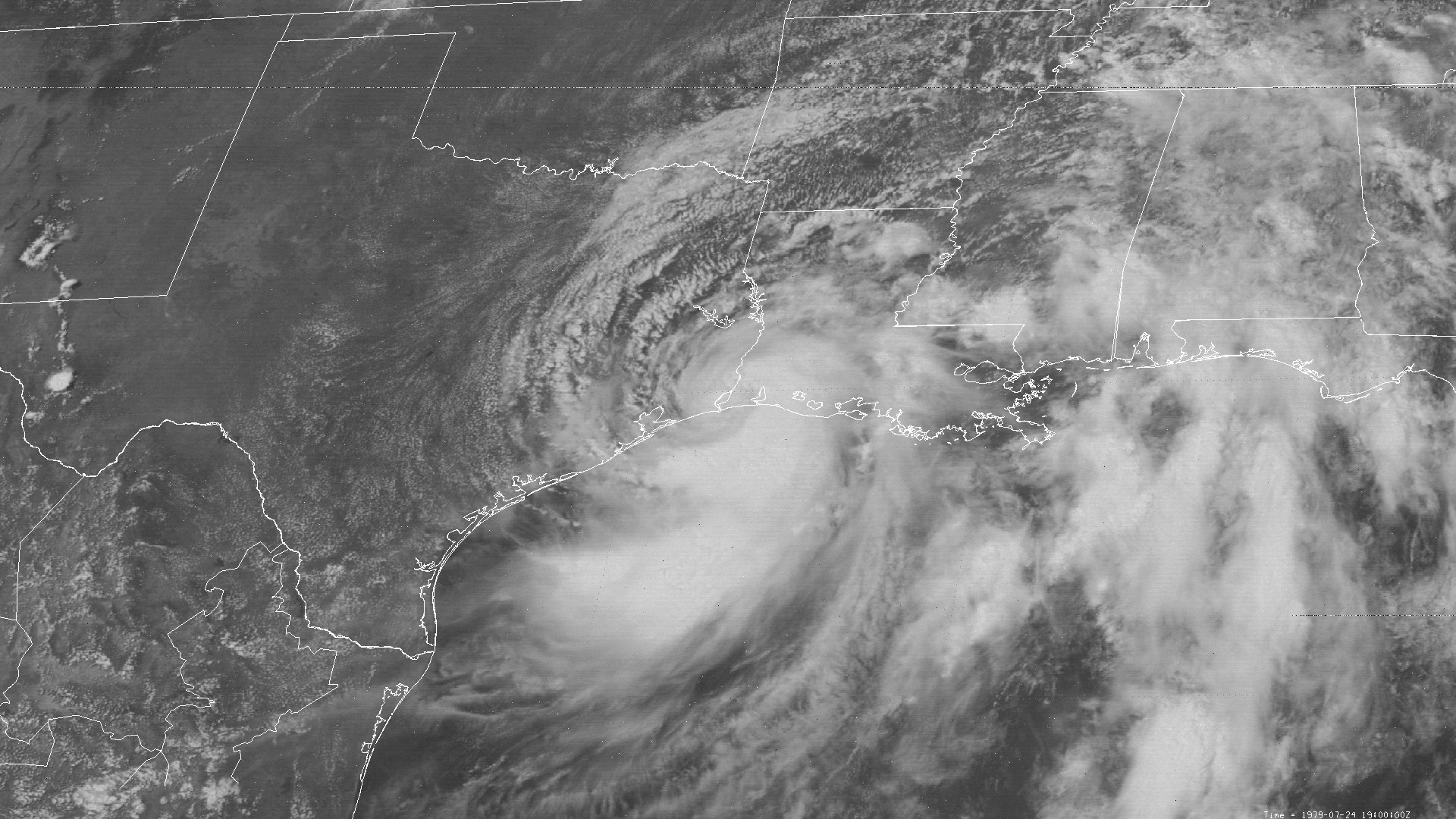
Above: SMS-2 visible satellite image of Tropical Storm Claudette at 2:00 PM CDT July 24, 1979, just after landfall around Sabine Pass, TX.
Tropical Storm Claudette originated from a tropical wave that emerged off the African coast on July 12th. The wave traversed westward across the Tropical Atlantic, gradually becoming better organized, and was designated Tropical Depression #5 after daybreak on July 15th. The depression continued west northwest, and turned westward as it approached the Northern Lesser Antilles. Just after daybreak on July 17th, an Air Force reconnaissance aircraft flight reported sustained surface winds around 50 mph, with the system being upgraded to Tropical Storm Claudette. Strong westerly wind shear weakened the storm back to a depression as it moved over Puerto Rico on July 18th. Tropical Depression Claudette continued westward across the Dominican Republic, Haiti, and just south of Cuba July 18th through July 21st entering the Southeast Gulf later that afternoon. Little change in organization occurred as Claudette continues west northwest across the Central Gulf through the early morning hours of July 23rd.
Just after daybreak on July 23rd, reconnaissance aircraft found that the system had regained tropical storm status with a broad poorly organized circulation centered approximately 200 miles south of the Southwestern Louisiana Coast. At this time, the mid to upper level ridge off the Southeast United States, along with a gradual weakening of the ridge over the Central United States, allowed Claudette to move north northwestward towards the Southwest Louisiana and Southeast Texas coast during the evening hours through the morning of July 24th. Claudette’s center became better defined, with gradual strengthening as it approached land.
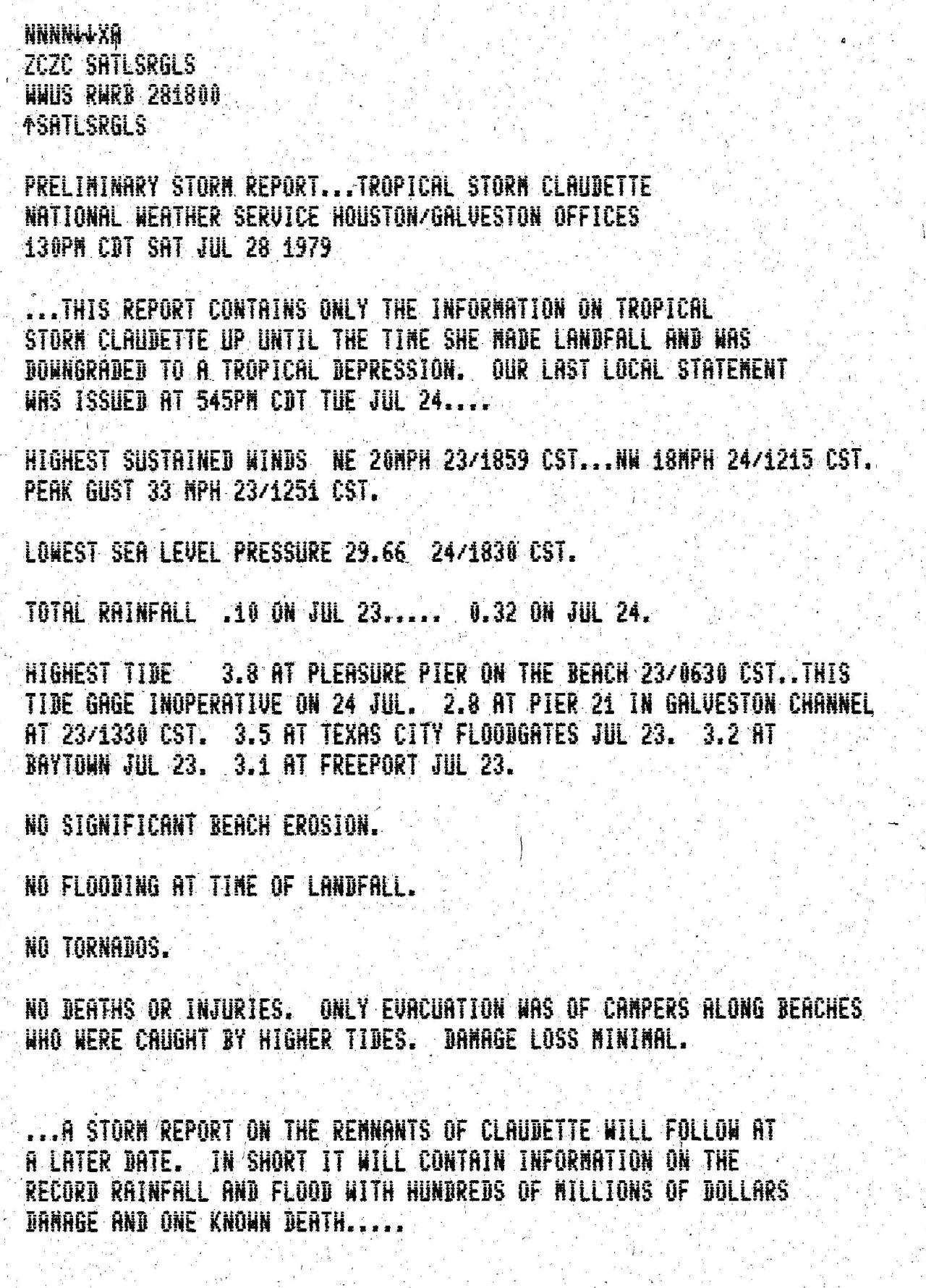
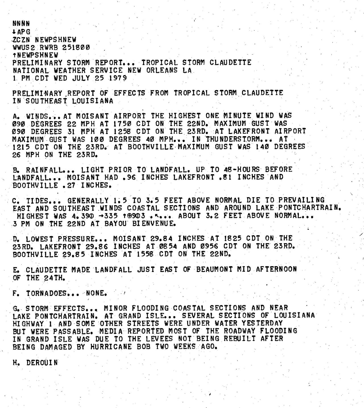
Tropical Storm Claudette made landfall near Sabine Pass, TX around 1 PM CDT July 24th with maximum sustained winds of 50 mph (45 knots). Claudette's minimum central pressure of 997 millibars (29.44 inches) occurred 5 hours after landfall as the center passed over the National Weather Service in Port Arthur, Texas. The mid to upper level pattern became dominated by high pressure ridges over the Southwest and Southeast U.S. This caused the steering currents to essentially collapse in between these two ridges where Claudette was located. This caused Claudette to stall and move erratically later that evening across Southeast Texas, and eventually make a tight clockwise loop just north of the Houston, TX metro area July 25th through July 26th. Due to the proximity near the Gulf, Claudette remained a tropical storm 18 hours after landfall, finally weakening to a tropical depression north of Houston. Due to Claudette stalling over Southeast Texas from July 24th through July 26th, catastrophic and historic rainfall amounts occurred across this area, setting the United States 24-hour rainfall record of 42 inches near Alvin, TX. Further details on storm totals can be found in the Rainfall section.
By July 27th, Tropical Depression Claudette began to lift northward across North Texas and Oklahoma, and eastward across Missouri on July 28th, and dissipated across West Virginia by daybreak on July 29th. Click here for an interactive track of Tropical Storm Claudette.
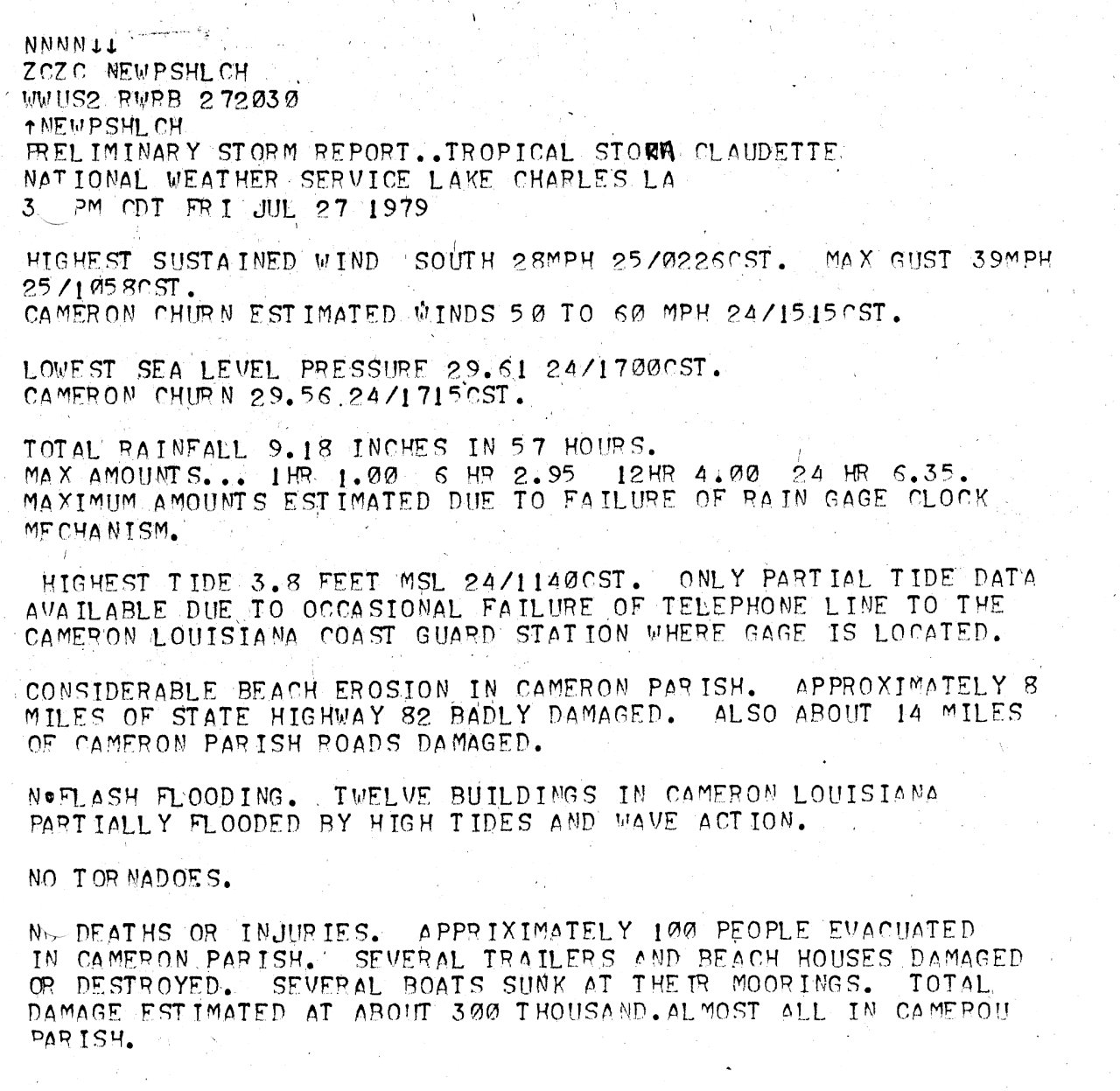
Due to the prolonged onshore flow ahead and after landfall of Claudette, storm surge and wave action caused extensive beach erosion across the Upper Texas and Southwest Louisiana coastlines. In Cameron Parish, about 8 miles of Highway 82 was damaged, as well as several camps in Johnson Bayou.
Tropical Storm Claudette historically high rainfall totals caused catastrophic flooding damage across the southern Houston metro area south to the coast and eastward to the Beaumont & Port Arthur, Texas region. Estimated damage (in 1979 dollars) of $400 million made Claudette the tenth costliest tropical cyclone in the United States at the time.
WIND & PRESSURE:
Claudette produced tropical storm force wind gusts across Southwest Louisiana and Southeast Texas. The National Weather Service Port Arthur, Texas recorded a maximum sustained wind of 53 mph (46 knots) and a peak wind gust of 60 mph (52 knots), along with a minimum sea level pressure of 997.6 millibars (29.46 inches) near the center of Claudette. Freeport, Texas and Cameron, Louisiana had estimated wind gusts up to 60 mph, with a peak gust of 46 mph recorded at Lafayette, Louisiana. It is interesting to note that most locations recorded the highest sustained winds and gusts between daybreak and noon on July 25th, some 18 to 24 hours after landfall. For complete meteorological statistics, see the Wind and Pressure section.
STORM SURGE:
Tides of 3 to 5 feet MSL occurred along the Upper Texas and Louisiana coasts. For other storm surge and high-water marks across our region, see the Storm Surge section.
RAINFALL:
Rainfall of 10 to nearly 20 inches occurred from Western Cameron Parish westward across Jefferson, Orange, and Hardin Counties in Southeast Texas. The highest storm total rainfall across our region was 19.24 inches in Port Arthur, Texas. Further west, 10 inches or greater occurred across the Southern halves of Chambers, Harris, Galveston, Brazoria, and Matagorda Counties. Rainfall of 30 inches or greater occurred across Western Galveston and Coastal Brazoria Counties. The greatest storm total rainfall of 45 inches occurred in Alvin, Texas, with 42 inches occurring in 24 hours, a record for the contiguous United States. For complete rainfall totals reported across our region, see the Rainfall section.
TORNADOES:
No tornadoes were reported in Louisiana or Southeast Texas.
|

