Lake Charles, LA
Weather Forecast Office
| Tropical Storm Debra | ||||||||||||||||||||||||||||||
| August 26-29, 1978 | ||||||||||||||||||||||||||||||
|
|
||||||||||||||||||||||||||||||
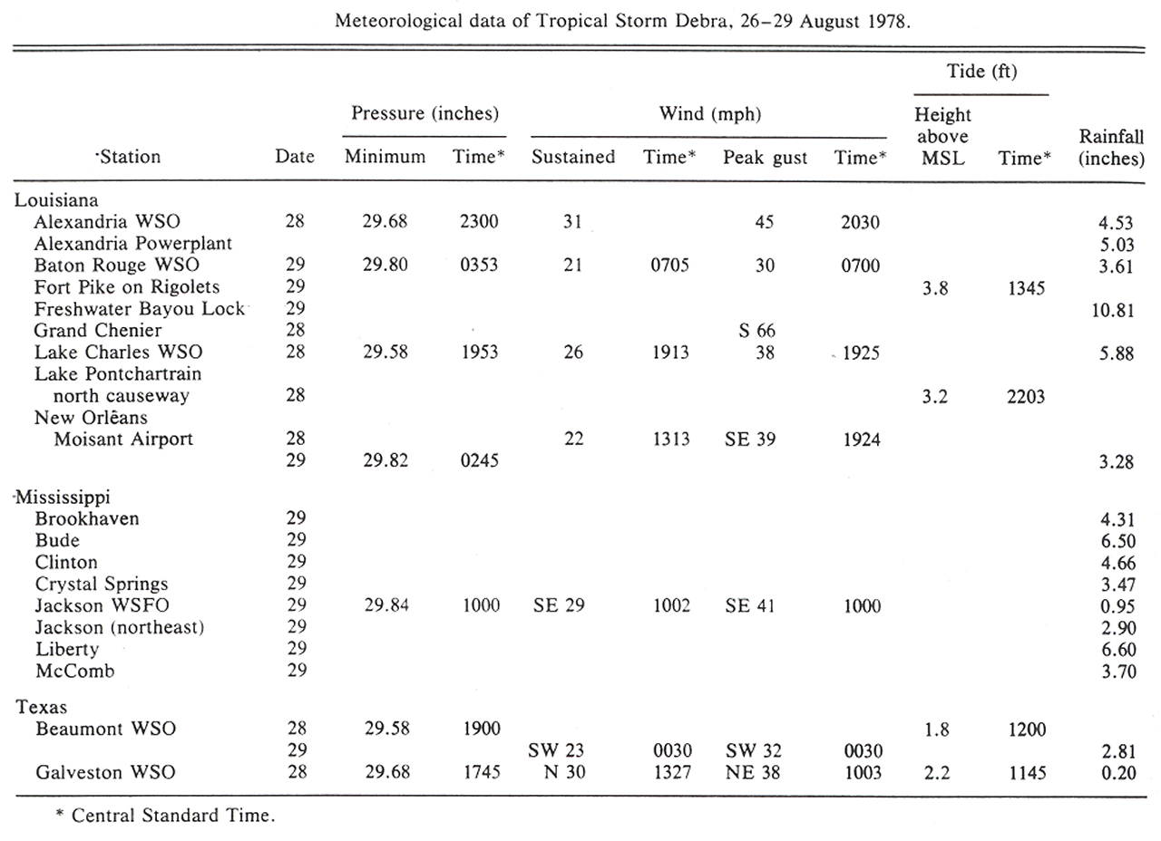
| Post Tropical Cyclone Report Summary from National Weather Service Source: Monthly Weather Review, April 1979 |
||||
 |
||||
|
Hourly Surface Observations for August 28-29, 1978 |
||||
| Lafayette, LA (KLFT-WBAN) | 8/28 | 8/29 | ||
| Lake Charles Regional Airport, LA (KLCH-NWS) | 8/28 | 8/29 | ||
| Port Arthur Southeast Texas Regional Airport, TX (KBPT-NWS) | 8/28 | 8/29 | ||
| Alexandria Esler Field, LA (KESF-WBAN) | 8/28 | 8/29 | ||
| Fort Polk, LA (KPOE-Army) | 8/28 | 8/29 | ||
Forecasts
Aviation Weather
Activity Planner
Mardi Gras Decision Support
Marine Forecasts
Local Products
Model Data
Forecaster's Discussion
Fire Weather
Graphical Forecasts
Wet Bulb Globe Temps
Other Links
National Hurricane Ctr
Storm Prediction Ctr
Weather Prediction Ctr
Other Links
Office History
LCH StoryMap
Hazards
Severe Weather
Tropical Weather
National Outlooks
Local Storm Reports
Tropical Cyclone Reports
Current
Observations
Tide Data
Satellite Data
Hydrology
Calcasieu Par. Network
Jefferson Co. DD6 Network
River/Lake Forecasts
Radar
Shreveport (SHV)
New Orleans (LIX)
Fort Polk (POE)
Houston/Galveston (HGX)
Lake Charles (LCH)
Probabilistic Pages
Probabilistic Snowfall
Probabilistic Rainfall
Probabilistic DSS
US Dept of Commerce
National Oceanic and Atmospheric Administration
National Weather Service
Lake Charles, LA
500 Airport Boulevard
Lake Charles, LA 70607
(337) 477-5285
Comments? Questions? Please Contact Us.

