
Scattered severe thunderstorms capable of large hail in excess of two inches, strong tornadoes, and damaging wind gusts are likely across parts of the Upper Mississippi Valley and Midwest this evening. Heavy to excessive rainfall may bring a flooding threat to portions of the Central Plains to the Midwest through Thursday. The heatwave in the Central U.S. will begin to push South and East Thursday Read More >
Lake Charles, LA
Weather Forecast Office
| Hurricane Carmen | ||
| August 29-September 10, 1974 | ||
|
|
||
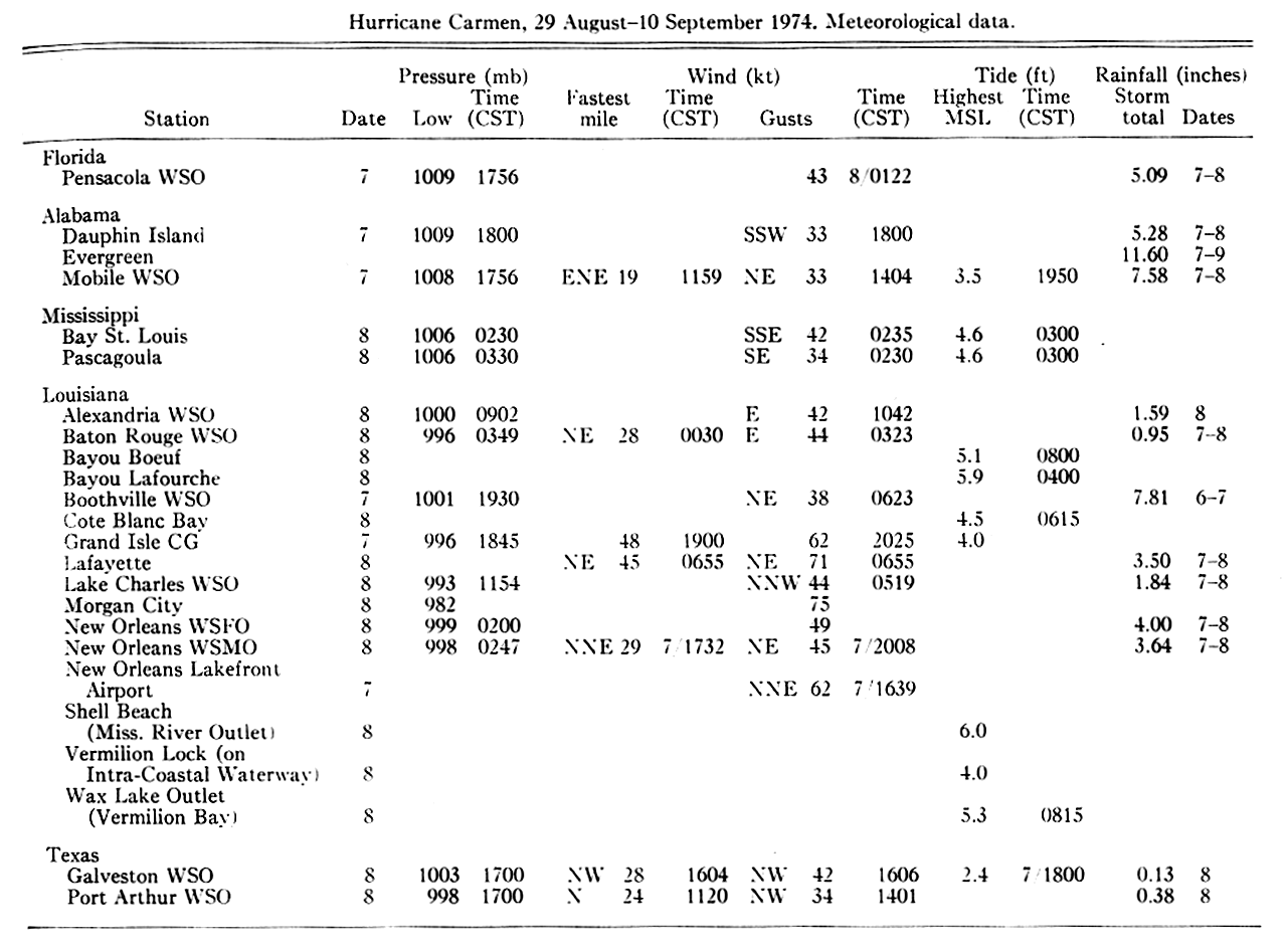
| Post Tropical Cyclone Report Summary from National Weather Service Source: Monthly Weather Review, April 1975 |
||||
 |
||||
|
Hourly Surface Observations for September 7-8, 1974 |
||||
| Lafayette, LA (KLFT-WBAN) | 9/07 | 9/08 | ||
| Lake Charles Regional Airport, LA (KLCH-NWS) | 9/07 | 9/08 | ||
| Port Arthur Southeast Texas Regional Airport, TX (KBPT-NWS) | 9/07 | 9/08 | ||
| Alexandria Esler Field, LA (KESF-WBAN) | 9/07 | 9/08 | ||
| *Fort Polk, LA (KPOE-Army) | 9/08 | |||
Forecasts
Model Data
Forecaster's Discussion
Fire Weather
Graphical Forecasts
Wet Bulb Globe Temps
Aviation Weather
Activity Planner
Mardi Gras Decision Support
Marine Forecasts
Local Products
Other Links
National Hurricane Ctr
Storm Prediction Ctr
Weather Prediction Ctr
Other Links
Office History
LCH StoryMap
Hazards
Severe Weather
Tropical Weather
National Outlooks
Local Storm Reports
Tropical Cyclone Reports
Current
Tide Data
Satellite Data
Observations
Hydrology
River/Lake Forecasts
Calcasieu Par. Network
Jefferson Co. DD6 Network
Radar
Shreveport (SHV)
New Orleans (LIX)
Fort Polk (POE)
Houston/Galveston (HGX)
Lake Charles (LCH)
Probabilistic Pages
Probabilistic DSS
Probabilistic Snowfall
Probabilistic Rainfall
US Dept of Commerce
National Oceanic and Atmospheric Administration
National Weather Service
Lake Charles, LA
500 Airport Boulevard
Lake Charles, LA 70607
(337) 477-5285 M-F 8a to 4p only
Comments? Questions? Please Contact Us.

