|
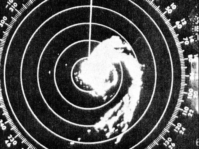
Above: Lake Charles, LA WSR-57 radar image of Hurricane Edith at 10:08 AM CDT on September 16, 1971 shortly after landfall.
Hurricane Edith originated as a tropical wave moving off the African coast on August 31st. By September 5th, the system organized enough to be classified a tropical depression near the Lesser Antilles. By daybreak on September 7th, the system reached tropical storm status, given the name Edith.
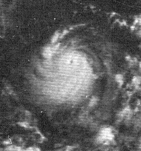
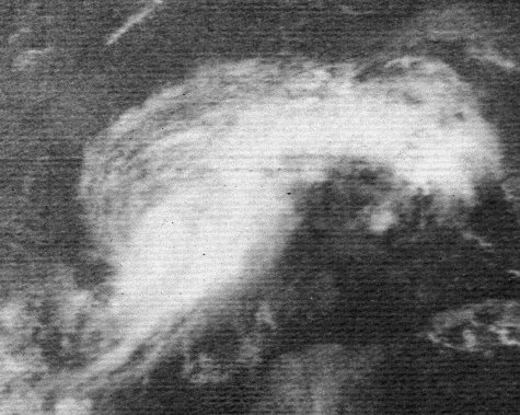
Tropical storm Edith continued westward across the Southern Caribbean Sea and intensified rapidly, reaching hurricane strength early on September 8th. Edith continued to intensify rapidly, reaching category five status by midday on September 9th, some 36 hours later. The explosive strengthening episode was observed by reconnaissance pilots of NOAA’s DC-6 (39 Charlie), noting extreme turbulence. Here is an airborne radar photograph of Hurricane Edith as it approached Capc Gracias, Nicaragua, on September 9, 1971 at 1303Z (9:03 EDT). An ATS-3 visible satellite image on September 9, 1971 at 1339Z (8:39 AM EDT) shows an extremely well-defined hurricane. Edith made landfall across the northeastern coast of Nicaragua at Cabo Gracias a Dios at category five strength of 160 mph.
Hurricane Edith weakened rapidly after landfall, and continued to weaken to tropical storm strength just before the second landfall across the coast of Belize late on September 11th. Edith continued to cross the Yucatan Peninsula, emerging in the Bay of Campeche late on September 12th. Edith continued west-northwest across the Southern Gulf as a moderate tropical storm, briefly stalling just off the coast of Tamaulipas Mexico early on September 14th.
A deepening longwave mid to upper level trough of low pressure approached Edith, and caused the storm to begin moving northeast and intensify once again. Edith regained hurricane strength off the South Texas coast east northeast of Brownsville by midday on September 15th, as shown by the ATS-3 visible satellite image. Edith continued to intensify into the night as it moved northeast. Edith made landfall between Grand Chenier and Rockefeller Wildlife Refuge in Cameron Parish around 8 AM CDT on September 16, 1971 as a category two hurricane with maximum sustained winds around 100 mph (85 knots) and a minimum central pressure around 978 millibars (28.88 inches). The National Weather Service Lake Charles, LA WSR-57 radar shows Hurricane Edith at 10:08 AM CDT on September 16, 1971 shortly after landfall.
After landfall, Edith weakened to a category one by the time it passed over Lafayette, Louisiana around 11 AM CDT. Edith weakened to a strong tropical storm by the time it passed just north of the National Weather Service office in Baton Rouge just after 1 PM CDT. Edith continued weakening as it headed into Southern Mississippi. Click here for an interactive track of Hurricane Edith.
Moderate wind damage along and south of the path of Edith was observed. Numerous trees were uprooted, powerlines and poles were broken or downed, with extensive tree limb breakage. Signs and billboards were toppled, along with damage to roofs, plate glass, mobile homes, barns and lighter structures.
Across coastal Cameron, Vermilion, Iberia, and St. Mary parishes, the 6 to 10 foot storm surge swept some camps off the blocks, as well as depositing a layer of silt and mud. Damage to crops was extensive, especially to sugarcane, soybeans and cotton, as well as fish kills.
WIND & PRESSURE:
The highest sustained wind of 69 mph with a peak gust of 96 mph was recorded at Cameron, Louisiana around 8 AM CDT. With the hurricane making landfall some 30 miles east of Cameron, higher winds were likely across Eastern Cameron and Vermilion parishes, but no observing equipment were available for observations. A peak wind of 69 mph, along with the lowest pressure of 985.7 millibars (29.11 inches), was observed at Lafayette, LA when the eye of Hurricane Edith passed overhead around 11:14 AM CDT. A peak wind of 72 mph was measured at Morgan City, LA around 11:30 AM CDT. At the National Weather Service Lake Charles, LA, a peak wind of 58 mph was recorded around 8:37 AM CDT. For complete meteorological statistics, see the Wind and Pressure section.
STORM SURGE:
Post storm high water mark surveys conducted by the U.S. Army Corp of Engineers revealed the highest storm surge of 9.7 feet above MSL was observed at Cypremort Point, LA between Vermilion and West Cote Blanche Bays. Other readings found are as follows (above MSL): Sabine Pass, 4.0; Cameron, 4.3; Grand Cheniere, 5.9; Freshwater Bayou Lock, 7.4; Schooner Bayou Lock, 4.6; Vermilion Lock, 4.0; Charenton Drainage Canal near Baldwin, 5.2; Calumet, 5.5; Morgan City, 5.8; and Bayou Boeuf Lock, 6.0. Elevation of highwater marks along the Bayou Sale Ridge, which is located near East Cote Blanche Bay, ranged from 5.3 at Ellerslie to 9.3 at the mouth of Bayou Sale. For other storm surge and high-water marks across our region, see the Storm Surge section.
RAINFALL:
Rainfall across the region ranged from 5 to 8 inches along the track of Edith in Southern Louisiana, with a maximum of 8.29 at Lake Arthur. Flooding was common in low lying areas across South Louisiana due to the heavy rainfall and in some cases, the combination of storm surge and heavy rainfall. For complete rainfall totals reported across our region, see the Rainfall section.
TORNADOES:
Several tornadoes were reported across South Central and Southeast Louisiana on September 16th. An F1 tornado occurred around 8:20 AM CDT across Iberia and St. Martin parishes northeast of Loreauville, injuring 6 people. An F3 tornado occurred from 9:07-9:22 CDT across Eastern Baton Rouge, injuring 3 people and causing 2.5 million in damages. An F2 tornado occurred around 10:00 AM CDT across St. Mary parish in the town of Franklin. Across Tangipahoa parish, An F2 tornado occurred around 1 PM CDT near the town of Robert, with an F1 tornado around 1:30 PM just east of Independence. For complete details on all the tornadoes reported, see the Tornadoes section.
|

