Lake Charles, LA
Weather Forecast Office
| Hurricane Celia | ||
| July 31-August 5, 1970 | ||
|
|
||
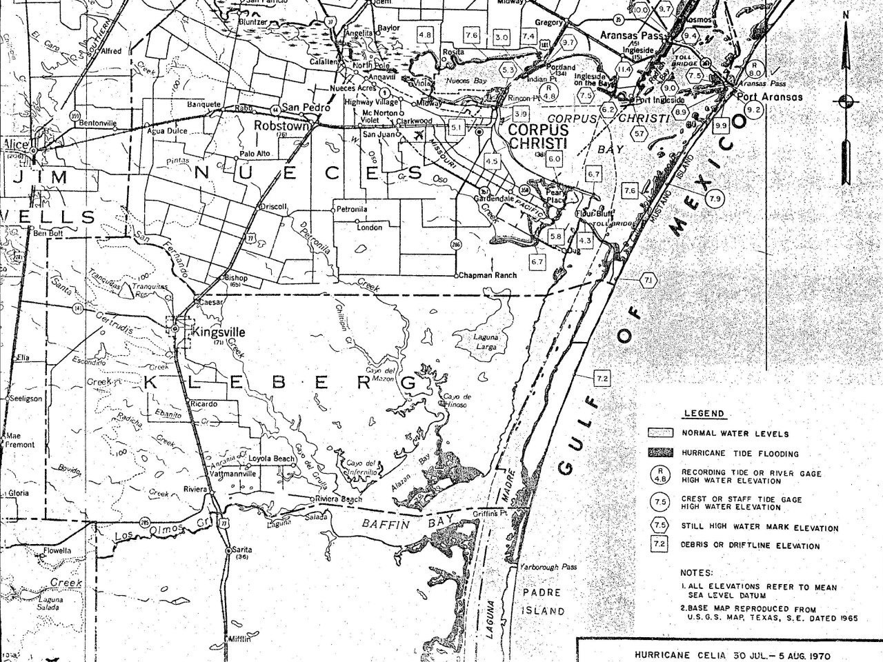
| Celia Storm Surge: Measured and High Water Marks Texas Map Sources: U.S. Army Corp of Engineers & U.S. Weather Bureau Surveys |
||||
 |
||||
| Celia Storm Surge: Measured and High Water Marks Source: Texas and Louisiana U.S. Weather Bureau Post Storm Surveys Source: National Hurricane Center Preliminary Report on Hurricane Celia |
||||
| Location | Feet (MSL) | |||
| Cameron, LA | 2.0 | |||
| Port Arthur, TX | 2.8 | |||
| Sabine Pass, TX | 2.5 | |||
| Galveston Channel, TX | 3.0 | |||
| Galveston Pleasure Pier, TX | 4.0 | |||
| Texas City, TX | 3.5 | |||
| San Leon, TX | 4.0 | |||
| Kemah/Seabrook, TX | 4.7 | |||
| La Porte, TX | 4.8 | |||
| Morgan Point, TX | 5.0 | |||
| Baytown, TX | 5.3 | |||
| Freeport, TX | 4.0 | |||
| Lavac Bay, TX | 5.8 | |||
| Port O'Conner, TX | 3.4 | |||
| Austwell, TX | 3.1 | |||
| Bayside, TX | 4.2 | |||
| Capano Bay, TX | 3.8 | |||
| Rockport, TX | 4.1 | |||
| Port Aransas Beach, TX | 9.2 | |||
| Port Aransas Jetty, TX | 9.0 | |||
| Mustang Island, TX | 7.9 | |||
| Corpus Christi, TX | 4.9 | |||
| Brownsville, TX | 1.5 | |||
Forecasts
Local Products
Model Data
Forecaster's Discussion
Fire Weather
Graphical Forecasts
Wet Bulb Globe Temps
Aviation Weather
Activity Planner
Mardi Gras Decision Support
Marine Forecasts
Other Links
National Hurricane Ctr
Storm Prediction Ctr
Weather Prediction Ctr
Other Links
Office History
LCH StoryMap
Hazards
Severe Weather
Tropical Weather
National Outlooks
Local Storm Reports
Tropical Cyclone Reports
Current
Tide Data
Satellite Data
Observations
Hydrology
Jefferson Co. DD6 Network
River/Lake Forecasts
Calcasieu Par. Network
Radar
Shreveport (SHV)
New Orleans (LIX)
Fort Polk (POE)
Houston/Galveston (HGX)
Lake Charles (LCH)
Probabilistic Pages
Probabilistic Rainfall
Probabilistic DSS
Probabilistic Snowfall
US Dept of Commerce
National Oceanic and Atmospheric Administration
National Weather Service
Lake Charles, LA
500 Airport Boulevard
Lake Charles, LA 70607
(337) 477-5285 M-F 8a to 4p only
Comments? Questions? Please Contact Us.

