|
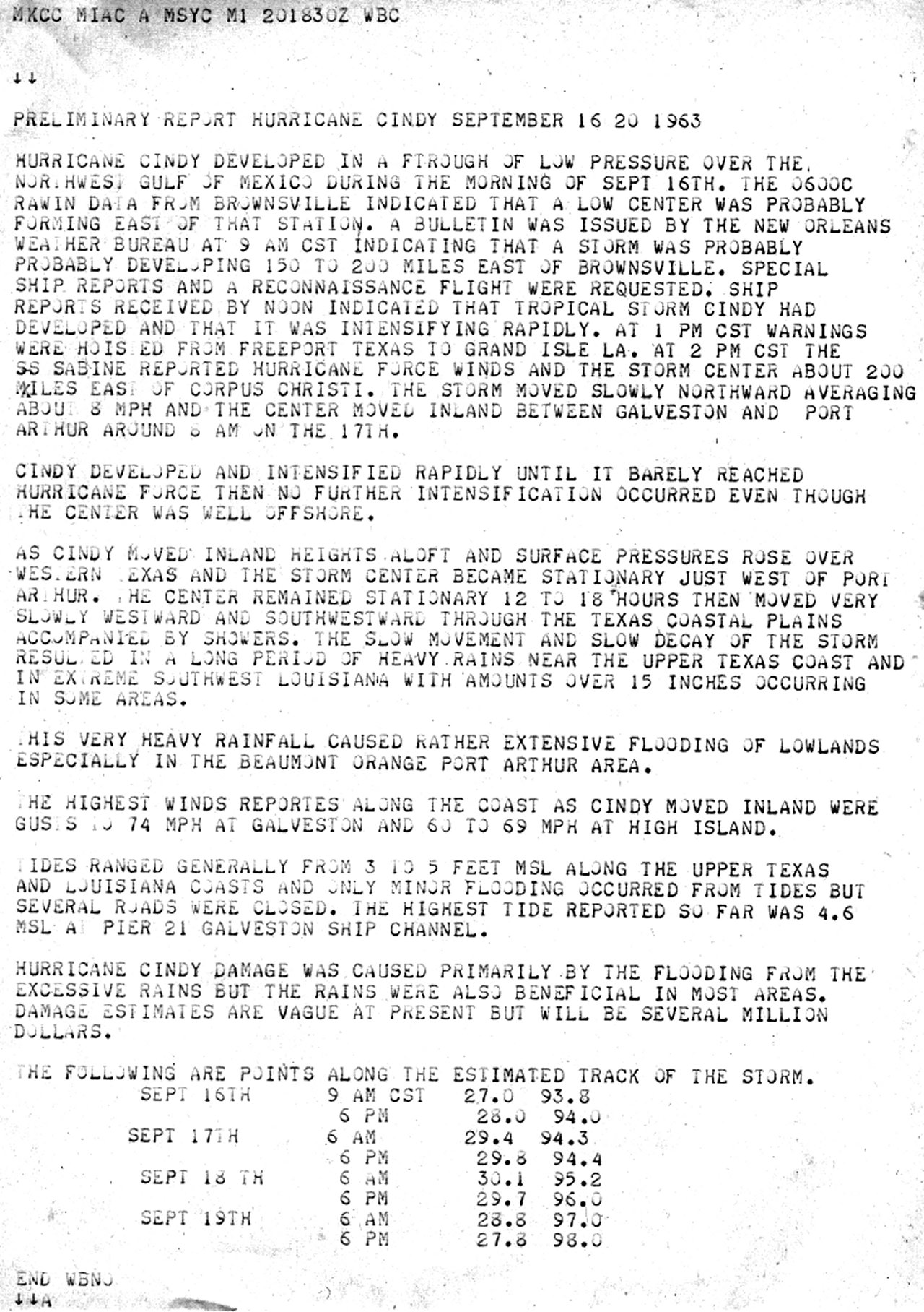
Tropical Storm Cindy developed rather quickly around daybreak on September 16th from an old frontal trough across the Northwest Gulf about 150 miles south of the Upper Texas coast. High pressure at the surface and aloft over the Eastern Gulf allowed the storm to move northward and intensify, reaching a peak intensity of 65 mph (55 knots) later that evening.
Cindy continued northward with little change in strength overnight into the morning hours of September 17th. Cindy made landfall just east of High Island, Texas across Jefferson county around 8 AM CST with maximum sustained winds of 65 mph (55 knots) and a minimum central pressure of 997 millibars (29.44 inches).
At the time of landfall, Cindy’s northward motion slowed down with the system drifting to the northwest as high pressure aloft strengthened over the Central U.S. Cindy weakened to a tropical depression by daybreak on September 18th while centered just north of Houston, Texas. Thereafter, the depression drifted southwestward for the remainder of the 18th into the 19th, finally dissipating across South Texas. Click here for an interactive track of Tropical Storm Cindy.
Storm surge ranged from 3 to 4 feet MSL along the coastline of Cameron Parish and Jefferson County. This, in combination with the wave action, damaged portions of Highway 82 between Holly Beach and Constance Beach in Cameron Parish, and Highway 87 along coastal Jefferson County. With the slow movement after landfall, torrential rainfall occurred over Southeast Texas and extreme Southwest Louisiana, causing widespread major flooding. See the rainfall sections and tables for storm total precipitation. Three deaths and over 12 million dollars (in 1963) was attributed to Cindy.
Cindy was originally designated a minimal hurricane at 75 mph (65 knots) just before and at landfall per the original post storm reports. This storm was investigated by the ongoing Hurricane Re-Analysis Project of the Hurricane Research Division, could not find any observations of sustained hurricane force winds from ships or aircraft reconnaissance data. Thus, Cindy was downgraded to a tropical storm during the period from September 16th to the time of landfall on September 17th.
WIND & PRESSURE:
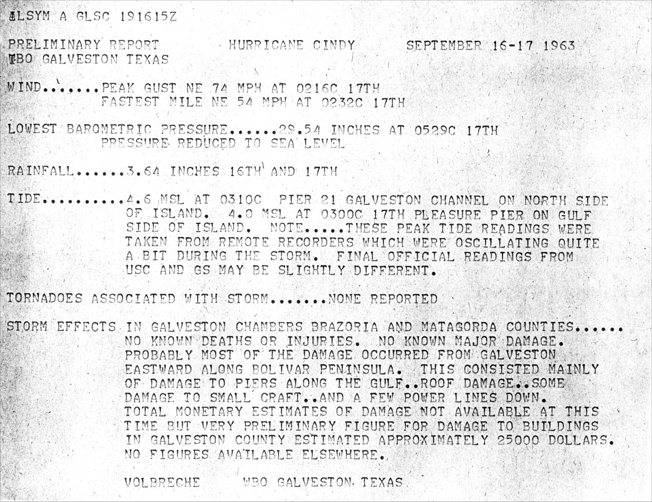
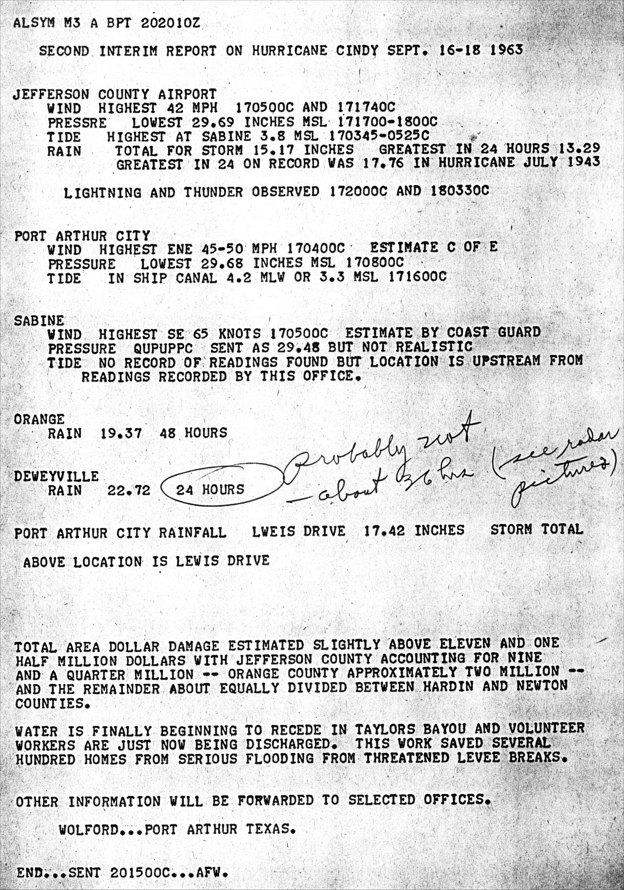
The U.S. Weather Bureau Galveston, TX reported highest sustained winds of 54 mph (47 knots) at 2:16 AM CST, a peak wind gust of 74 mph (64 knots) at 2:32 AM CST, and a minimum central pressure of 1000.3 millibars (29.54 inches) at 5:29 AM CST on September 17th. The U.S. Weather Bureau Port Arthur, TX reported highest sustained winds of 31 mph (27 knots) at 2:00 PM CST, a peak wind gust of 42 mph (37 knots) at 5:00 AM CST, and a minimum central pressure of 1005.4 millibars (29.69 inches) at 5:00 PM CST on September 17th. The U.S. Weather Bureau Lake Charles, LA reported highest sustained winds of 23 mph (20 knots) at 3:20 PM CST, a peak wind gust of 35 mph (30 knots) at 7:30 AM CST, and a minimum central pressure of 1010.8 millibars (29.85 inches) at 6:00 PM CST on September 17th.
STORM SURGE:
The highest storm surge recorded with Cindy was 4.6 feet MSL in Galveston, Texas. Further east, a surge of 3.8 feet MSL was recorded at Sabine Pass, Texas and 3.3 feet MSL at Port Arthur, Texas. In Cameron Parish Louisiana, a surge of 4.0 feet MSL was measured at Holly Beach and Cameron, a surge of 3.8 feet MSL measured in Hackberry, and 2.5 feet MSL at Rockefeller Wildlife Refuge near Grand Chenier. For other storm surge and high-water marks across our region, see the Storm Surge section.
RAINFALL:
Due to the very slow movement after landfall, the highest rainfall amounts occurred across Southeast Texas and extreme Southwest Louisiana ranging from 12 to 23 inches. The highest rainfall totals were 23.50 inches in Deweyville, Texas, 22.80 inches in Orange, Texas, and 18.30 inches in Vinton, Louisiana. This caused widespread major flooding across Beaumont, Port Arthur, and Orange, Texas into western Calcasieu and Cameron Parishes in Southwest Louisiana. Further inland across Southeast Texas, rainfall amounts of 6 to 12 inches were common, as well as portions of Southern Louisiana south of U.S. highway 90. Lesser amounts of 3 to 6 inches were recorded across Central Louisiana. For complete rainfall totals reported across our region, see the Rainfall section.
TORNADOES:
No tornadoes were reported.
|

