|
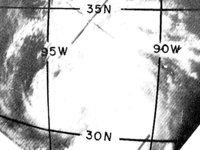
Above: TIROS 5 visible satellite image of Tropical Depression #3 at 10:00 AM CST on August 29, 1962.
A tropical depression formed in the western Gulf in the Bay of Campeche late on August 26th. The system moved northward across the Western Gulf on August 27th and 28th with no significant strengthening. According to surface observations from the Weather Bureau offices in Port Arthur Texas and Lake Charles, Louisiana, the center of the depression is estimated to have crossed the coast early on August 29th between Midnight and 2 AM CST. TIROS-5 captured a visible satellite image around 10 AM CST on August 29th when the depression was centered just inland across Southeast Texas and Southwest Louisiana. The depression continued northward across East Texas just west of the Sabine River, dissipating by August 30th.
Most of the rainfall, and strongest squalls, occurred along and east of the track across Southeast Texas and Southwest Louisiana. During the afternoon and evening of August 28th before landfall, the outer bands, or squalls in this case, produced severe thunderstorm wind gusts, very heavy rainfall including the Louisiana 24 hour rainfall record at Hackberry, and two tornadoes reported in Cameron Parish.
This storm was investigated by the ongoing Hurricane Re-Analysis Project of the Hurricane Research Division, and did not find sufficient evidence for upgrading this tropical depression to a tropical storm.
WIND & PRESSURE:
Highest sustained winds of 20 to 25 mph were reported at the Weather Bureau offices in Port Arthur Texas and Lake Charles, Louisiana. Across Cameron parish, much higher wind gusts were observed with the severe thunderstorms and two tornadoes reported in Cameron, with the courthouse reporting a wind gust to 80 mph. The highest sustained wind recorded was 40 mph (35 knots) on an oil rig off the coast. Since the oil rig was an elevated site, the winds at the surface were likely below tropical storm force. No land-based stations reported tropical storm force winds.
STORM SURGE:
No significant storm surge or higher tides were reported across coastal Jefferson County or Cameron Parish.
RAINFALL:
The highest rainfall amounts occurred across Southwest Louisiana in Cameron and Calcasieu parishes, where 6 to 24 inches of rainfall occurred. The Sabine National Wildlife Refuge in Hackberry, Louisiana recorded 24.40 inches. 22.00 inches of this total was recorded within 24 hours on August 28-29, 1962, which remains Louisiana’s record 24-hour rainfall. Further north across Calcasieu parish, 10 to 14 inches of rainfall occurred across Lake Charles, Louisiana. With these high rainfall totals, severe freshwater flooding occurred from Lake Charles southward to Cameron from August 28th through the 30th. Across Central and West Central Louisiana, rainfall of 3 to 6 inches was recorded. Across South Central Louisiana and Southeast Texas, lesser rainfall amounts of one to three inches occurred. For complete rainfall totals reported across our region, see the Rainfall section.
TORNADOES:
Two tornadoes were reported in Cameron. The first tornado was reported at 9:55 PM CST August 28th and rated an F0. The second tornado was reported at 10:10 PM CST and rated an F1. These tornadoes were responsible for 2 deaths, 30 injuries, and damaged 109 houses and 16 trailers. For complete details on all the tornadoes reported, see the Tornadoes section.
|

