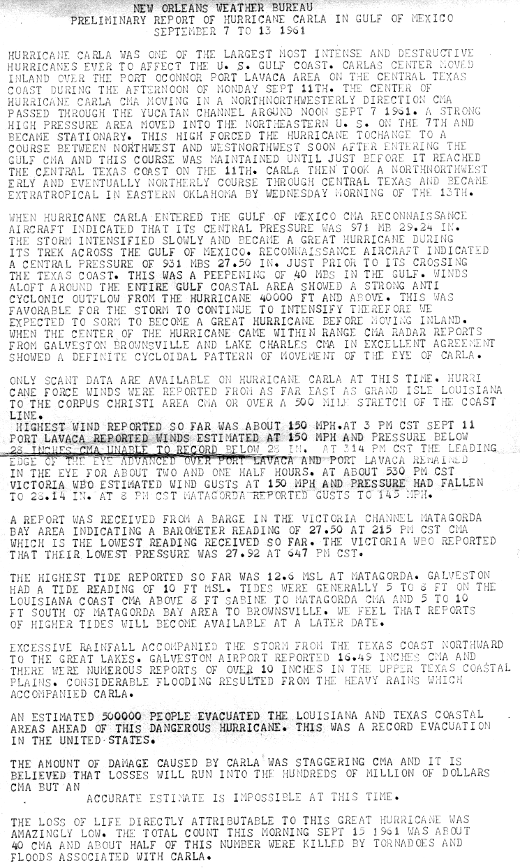
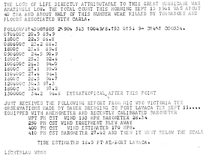
|
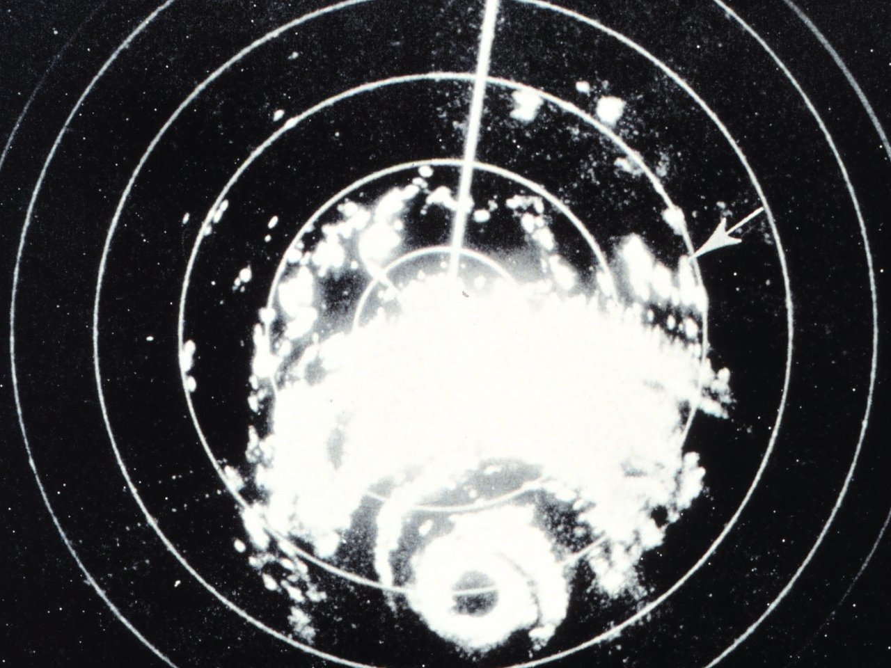
Above: Galveston, TX WSR-57 radar image of Hurricane Carla at 2:50 PM CST on September 10, 1961.
Carla developed in the southwestern Caribbean Sea around daybreak on September 3rd as a tropical depression. It strengthened slowly while heading northwestward, and by daybreak September 5th, the system was upgraded to Tropical Storm Carla. Carla was upgraded to a hurricane early on September 6th, then moved northward toward the Yucatán Channel. Carla moved through the Yucatán Channel during the day on September 7th and entered the Gulf later that afternoon and became a major hurricane by that evening. It was noted by several surface observations and aircraft reconnaissance flights that Carla was becoming an unusually large hurricane, as well as increasing in strength.
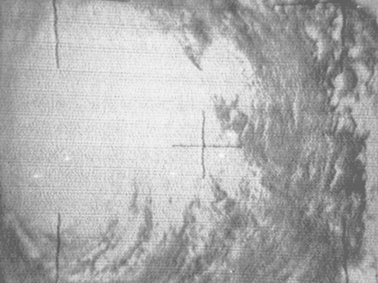
Hurricane Carla continued to intensify and grow in size in the Gulf. The WSR-57 radar in Galveston, TX captured this image while the hurricane was approaching the Central Texas coast at 2:50 PM CST on September 10th. This early TIROS 3 visible satellite photo at 3:22 PM CST September 10th shows the cloud cover covering most of the Gulf.
Carla continued to intensify, and by the early morning hours of September 11th, reached a peak intensity of 145 mph (125 knots) with a minimum central pressure of 927 millibars (27.37 inches). Hurricane Carla made landfall as a category 4 hurricane near Port O'Connor, Texas around 2 PM CST with an intensity of 145 mph (125 knots) with a minimum central pressure of 931 millibars (27.49 inches).
Carla slowly weakened while heading inland across Central Texas, but was still a minimal hurricane southeast of Austin early on September 12th, and a weakening tropical storm by the time it reached Forth Worth, Texas later that evening. Carla transitioned into an extratropical cyclone by daybreak on September 13th, while centered over southern Oklahoma. Rapidly moving northeastward, Carla's remnants reached the Labrador Sea, Canada and dissipated on September 17, 1961. Click here for an interactive track of Hurricane Carla.
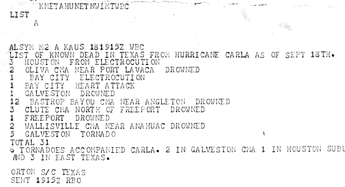
Carla was considered one of the largest major Gulf hurricanes in the 20th century. There were 43 deaths, approximately half attributable to tornadoes and floods accompanying the hurricane and property damage estimated at over $300 million. Loss of life was held to a minimum by prompt evacuations. Over a quarter-million persons were reported evacuated from coastal and low-lying areas.
Carla’s storm surge and wave action caused major damage to the coastal locations of Southeast Texas and Southwest Louisiana. In Jefferson County, Texas, severe beach erosion was observed and Highway 87 along the coast was destroyed. Structures along the beach not elevated high enough were destroyed. Sabine Pass was inundated with storm surge, and 3 to 4 feet of water flooded portions of Port Arthur, TX. Across Cameron Parish, Louisiana, severe beach erosion was observed as well. A row of houses along the beach in Holly Beach were destroyed. At Hackberry, damage to oil storage tanks occurred. Damage was also seen along the Calcasieu Ship Channel northward to Lake Charles in Calcasieu Parish.
WIND & PRESSURE:
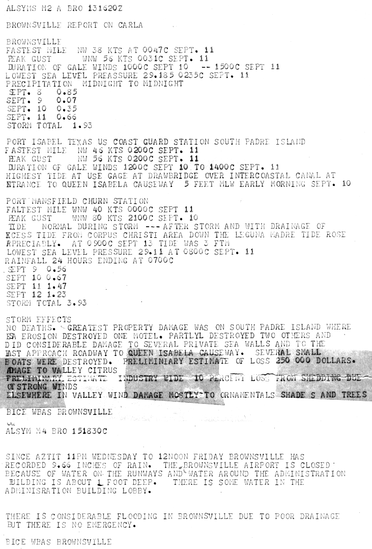
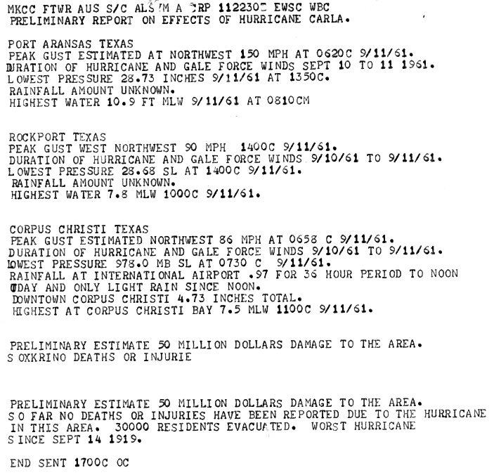
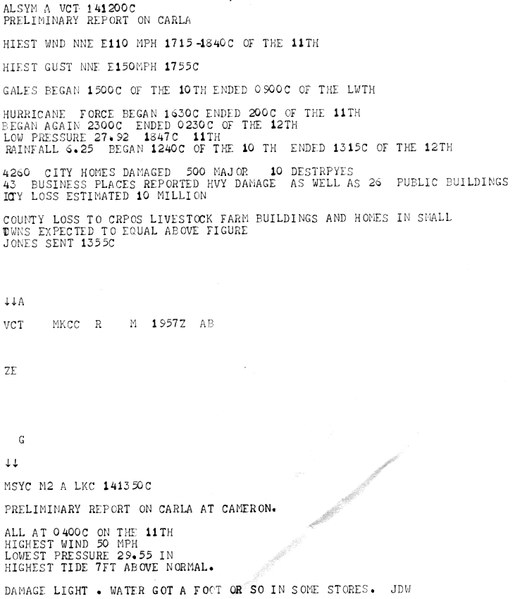
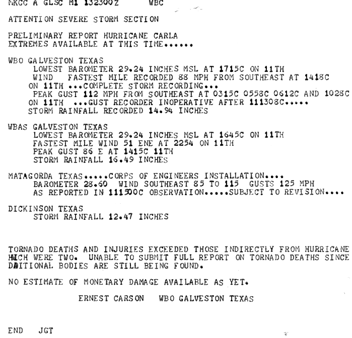
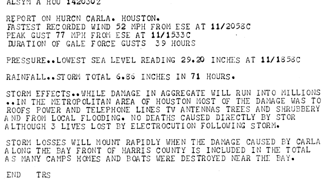
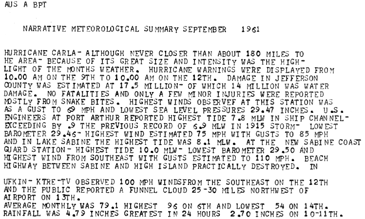
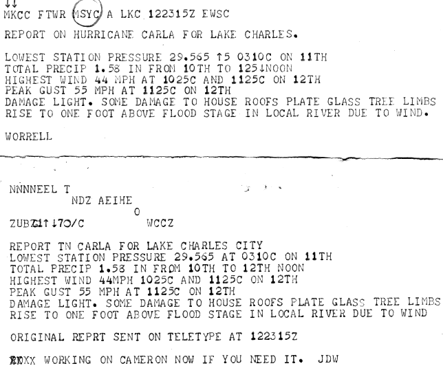
The highest winds associated with Carla were along the Texas coast, where hurricane force wind gusts were observed from Port Mansfield to Galveston. The U.S. Weather Bureau at the Jefferson County Airport reported highest sustained winds of 49 mph (34 knots) at 7:12 AM CST and a peak wind gust of 69 mph (60 knots) at 12:15 AM CST September 11th. The U.S. Weather Bureau at Lake Charles, LA reported highest sustained winds of 44 mph (38 knots) at 10:25 AM CST and a peak wind gust of 55 mph (48 knots) at 11:20 AM CST September 12th. For complete meteorological statistics, see the Wind and Pressure section.
STORM SURGE:
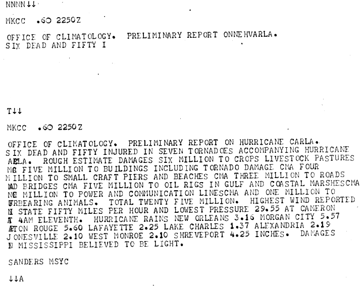
Being a very large hurricane, high storm surge values were observed along the Texas and Louisiana coasts. Post storm surveys by the Texas and Louisiana U.S. Weather Bureau stations and U.S. Army Corp of Engineers show storm surge exceeded 10 feet above MSL along the Texas coast from Sabine to Aransas Pass. The highest tide reported was 18.5 feet at Port Lavaca. Other locations experiencing high tides were Matagorda with 12.6 feet, Aransas Pass 10.9 feet, Galveston 10.0 feet, Sabine Pass 8.8 feet, and Port Arthur 7.8 feet. Along the Louisiana coast, Cameron reached 6.5 feet, Grand Cheniere 7.5 feet, Morgan City 4.5 feet, and Eugene Island 7.1 feet. For other storm surge and high-water marks across our region, see the Storm Surge section.
RAINFALL:
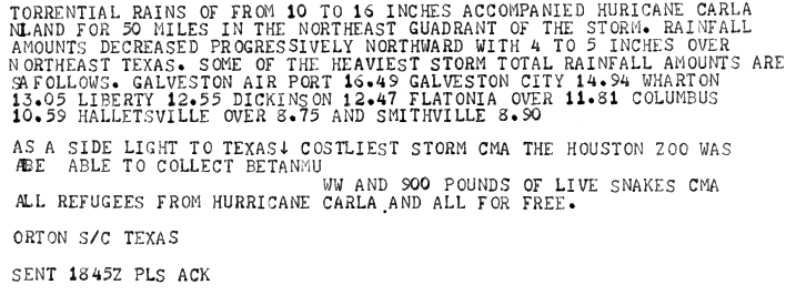
Rainfall of 10 to 15 inches were common across the Central Texas coast between Corpus Christi to Galveston and further inland. Across Southeast Texas, Central and Southern Louisiana, significantly less rainfall occurred, ranging from 1 to 9 inches. For complete rainfall totals reported across our region, see the Rainfall section.
TORNADOES:
One of the largest and deadliest tornado outbreaks occurred within the large circulation of Hurricane Carla. Numerous tornadoes were reported within the rain bands to the north and east of the eye across East Texas and Louisiana from September 10-13th.
Across Louisiana, most of the tornadoes occurred from the afternoon of September 10th into the morning hours of the 12th. The first tornado reported in Kaplan in northern Vermilion parish at 4:50 PM CST September 10th, and was one of two F3 tornadoes reported in Louisiana. This tornado was responsible for one death and 55 injuries, along with 2.5 million in damages. Another F1 tornado was reported near the Intracoastal Waterway in southeast Vermilion parish. An F1 tornado was reported in St. Mary parish near Morgan City around 6:12 PM CST. A stronger F2 tornado was recorded from Morgan City to Patterson around 10:20 PM CST with 16 injuries reported. On September 11th, tornadoes ranging from F0 to F2 were recorded over Southeast Louisiana across Livingston, Tangipahoa, and St. Tammany parishes. The F2 tornado in St. Tammany parish was reported in Slidell with 2 injuries. On September 12th further north across North Louisiana, an F3 tornado was recorded around 1 PM CST in Jonesboro across Jackson parish, killing 5 and injuring 37 others. An F2 tornado was reported at 3 PM CST across Union parish just east of Junction City, injuring 2. An F1 tornado was reported in Bienville parish around 8:30 AM CST on September 13th.
Across Southeast Texas, most of the tornadoes reported ranged from F2 to F4 intensity from the afternoon of September 11th into the morning hours of the 12th. The morning and afternoon leading up to Carla’s landfall on September 11th, an F2 tornado was reported at Bay City in Matagorda county around 11:47 AM CST. An F3 tornado occurred near Jacksonville in Cherokee county around 1:20 PM CST with 3 injuries. Another F3 tornado occurred in Harris county near Channelview in the eastern Houston metro area around 5:50 PM CST, injuring 22 people. Early on September 12th, an F4 tornado occurred in Galveston around 3:15 AM CST, and still stands as the strongest and deadliest tropical cyclone tornado ever recorded in Texas, with 8 deaths and around 200 injuries. Another F3 tornado struck Galveston later that morning around 6 AM CST, but no additional injuries were reported. Another F3 tornado occurred around 7:30 AM CST in Liberty county in the town of Hardin. The next day on September 13th, and F2 tornado occurred at 5:05 PM CST across Panola county near the town the Panola.
For complete details on all the tornadoes reported, see the Tornadoes section.
|

