|
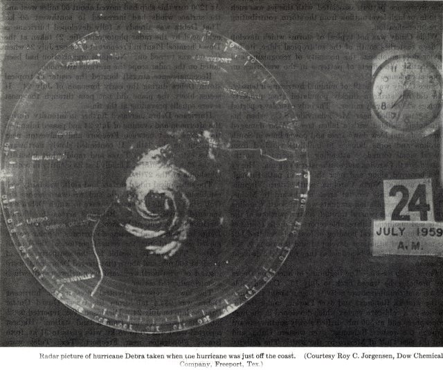
Above: An early radar photo (owned by Dow Chemical Company in Freeport, Texas) at 7:33 AM CST July 24, 1959.
An area of disturbed weather originating over the Bahamas moved across the Gulf July 20th and 21st. The disturbance gradually organized into a tropical depression late on July 22nd about 150 miles south of the Louisiana coast. The depression moved slowly to the west being steered by a mid to upper level ridge to the north. The depression, slow to organized at first, became Tropical Storm Debra the afternoon of July 23rd.
Tropical Storm Debra rapidly intensified overnight, and by daybreak on July 24th, had attained hurricane strength. An early radar photo (owned by Dow Chemical Company in Freeport, Texas) at 7:33 AM CST July 24th showed a well-defined eye and banding radar echoes associated with Hurricane Debra centered just off the upper Texas coast.
Weakening of the mid to upper level ridge allowed Hurricane Debra to move slowly northward, slowly intensifying for the remainder of the day. Hurricane Debra made landfall between Freeport and Galveston, Texas around 11 PM CST July 24th with maximum sustained winds of 85 mph (75 knots) and a minimum central pressure of 980 millibars (28.94 inches). Debra was downgraded to a strong tropical storm by daybreak July 25th as the center was passing over the Houston metropolitan area. Debra further weakened to a tropical depression early on July 25th moving across the remainder of East Texas and Oklahoma before dissipating on July 27th. Click here for an interactive map of Hurricane Debra.
WIND & PRESSURE:
The highest sustained winds across our area of responsibility in Southeast Texas was 45 mph near High Island Texas. A peak sustained wind of 33 mph (gust unknown) was recorded at the Port Arthur Weather Bureau office. Further west near the Brazos Floodgates near Freeport Texas near the eye landfall, sustained winds of 81 mph (70 knots) with gusts of 105 mph (91 knots) was the highest recorded winds. The Weather Bureau Galveston Texas office recorded maximum sustained winds of 57 mph (50 knots) with a peak gust of 85 mph (74 knots). The Weather Bureau Houston Texas office recorded maximum sustained winds of 58 mph (50 knots) with a peak gust of 82 mph (71 knots). Observations obtained from the Preliminary Report on Hurricane Debra, the Hurricane Re-analysis Project (1959) and hourly surface observations from the National Centers for Environmental Information (NECI).
STORM SURGE:
Storm surge of 1 to 2 feet above MSL occurred across coastal Jefferson County, with 1.6 feet MSL measured near High Island. Further west, higher storm surge of 2 to 7 feet MSL occurred across the Bolivar Peninsula and Galveston Bay, with 7.9 feet MSL recorded at Morgan Point, Texas on the northern end of Galveston Bay.
RAINFALL:
Rainfall of 8 to 15 inches was recorded over Southeast Texas and Southwest Louisiana, with 3 to 7 inches falling over the remainder of Central and South-Central Louisiana. The highest rainfall total of 15.89 inches occurred at Orange Texas. Across Calcasieu parish, 14.10 inches was recorded at Vinton, with 10.31 inches recorded at the Weather Bureau Lake Charles office near Chennault. For complete rainfall totals reported across our region, see the Rainfall section.
TORNADOES:
No tornadoes were reported.
Webpage design and content by: Donovan Landreneau
|

