NOAA Weather Radio All-Hazards (NWR), also known as the “Voice of the National Weather Service”, is a nationwide network of radio transmitters which broadcast continuous weather information from a nearby National Weather Service Office. It is one of the best and easiest ways to get weather information for your area. NWR broadcasts National Weather Service watches, warnings, statements, and forecast information 24 hours a day. Along with weather, other information including Hazardous Material Warnings, Civil Emergency Messages, and Amber Alerts can be broadcast over each transmitter. Anyone can purchase a NWR receiver, which come in a variety of styles and prices, and can be found in electronics stores across the country.
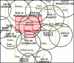
The National Weather Service Forecast Office in North Platte, Nebraska, operates six of the NWR transmitters which serve the residents of North Central, West Central, and Southwest Nebraska. The above image shows the locations of the transmitters which serve residents in this area, including transmitters which are operated by neighboring National Weather Service Forecast Offices. The circles around each transmitter represent the optimal range of reception, which is approximately 40 miles. Reception of the broadcast depends on numerous factors, including the type of receiver used, terrain, weather, and distance from the transmitter.
Below is information about each of the transmitters maintained by the National Weather Service in North Platte. All counties are in Nebraska unless otherwise noted.
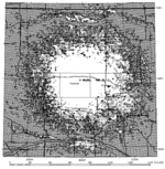
Left image highlights counties covered by each transmitter. Right image shows strength of the signal from each transmitter. White is "Most Reliable", Green is "Possible", Red is "Unlikely". Click on images to enlarge.
WXL 68 – Operates at a frequency of 162.550 megahertz near Sutherland.
Counties covered:
|
| Arthur |
Hayes |
Logan |
| Chase |
Keith |
McPherson |
| Frontier |
Lincoln |
Perkins |
|
 |
 |
WXL 73 – Operates at a frequency of 162.475 megahertz near Bassett.
Counties covered:
|
| Blaine |
Garfield |
Loup |
| Boyd |
Holt |
Rock |
| Brown |
Keya Paha |
Wheeler |
|
 |
 |
WXL 76 – Operates at a frequency of 162.400 megahertz near Merriman.
Counties covered:
|
| Sheridan |
Western Cherry |
| Bennett, SD |
|
 |
 |
WXN 72 – Operates at a frequency of 162.500 megahertz near Merna.
Counties covered:
WXN 82 – Operates at a frequency of 162.450 megahertz near Valentine.
Counties covered:
|
| Eastern Cherry |
| Todd and Tripp, SD |
|
 |
 |
KHA 55 – Operates at a frequency of 162.525 megahertz near Oshkosh.
Counties covered:
|
| Deuel |
Keith |
| Garden |
Perkins |
| Sedgwick, CO |
|
 |
 |
KPS 502 - Operates at a frequency of 162.425 megahertz near Mullen.
Counties covered:
|
| Cherry |
Grant |
| Hooker |
McPherson |
| Thomas |
|
 |
 |
Below is information about transmitters maintained by neighboring offices that cover portions of North Platte Warning Area in Western and North Central Nebraska.
Left image highlights counties covered by each transmitter in the North Platte Warning Area. Right image shows strength of the signal from each transmitter. White is "Most Reliable", Green is "Possible", Red is "Unlikely". Click on images to enlarge.
KXI 20 – Operates at a frequency of 162.525 megahertz near Chadron.
Counties covered:
|
| Box Butte |
Sheridan |
| Dawes |
Sioux |
|
 |
 |
WXL 67 – Operates at a frequency of 162.475 megahertz near Angora.
Counties covered:
|
| Banner |
Garden |
Scotts Bluff |
| Box Butte |
Kimball |
Sheridan |
| Cheyenne |
Morrill |
Sioux |
|
 |
 |
WNG 524 – Operates at a frequency of 162.500 megahertz near Trenton.
Counties covered:
|
| Dundy |
Hitchcock |
| Hayes |
Red Willow |
|
 |
 |
KEC 39 – Operates at a frequency of 162.525 megahertz near Cambridge.
Counties covered:
|
| Frontier |
Furnas |
| Gosper |
Red Willow |
| Decatur and Norton, KS |
|
 |
 |
KWN 62 – Operates at a frequency of 162.525 megahertz near Ord.
Counties covered:
|
| Custer |
Howard |
Valley |
| Garfield |
Loup |
Wheeler |
| Greeley |
Sherman |
|
|
 |
 |
KXI 25 – Operates at a frequency of 162.425 megahertz near Pickstown, South Dakota.
Counties covered:
| Boyd |
Holt |
| Charles Mix, Douglas, and Gregory, SD |
|
 |
 |


