|
Winter Weather Impacts Nebraska the First Week of December |
|
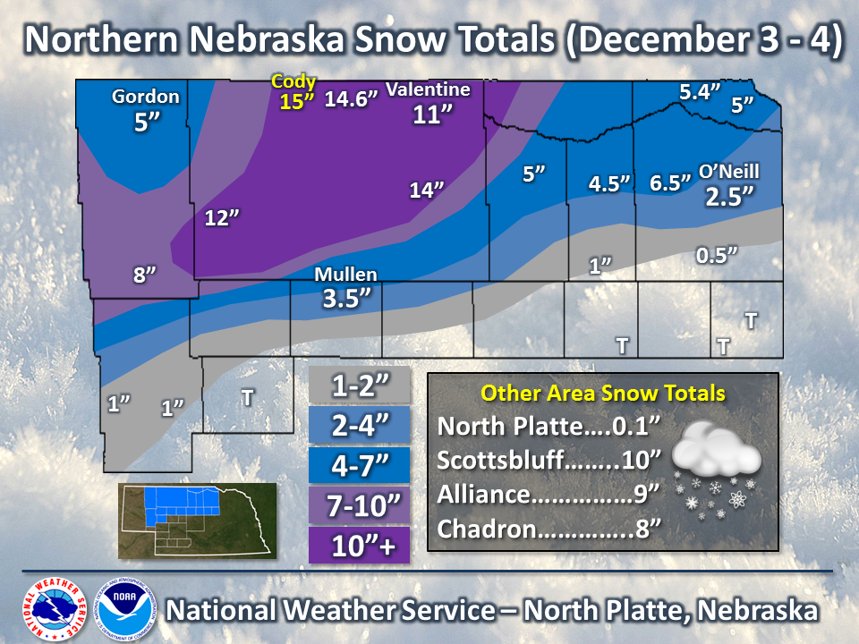
Heavy snow fell over Northern Nebraska December 3rd-4th as a large storm system moved across the country. In addition to the snow, strong winds and bitter cold temperatures impacted Nebraska the first week of the month. The hazardous weather brought the need for Winter Storm Warnings and Advisories, as well as Wind Chill Warnings and Advisories. A persistent band of snow set up across northern Nebraska by late morning on Tuesday, December 3rd, which continued to produce snow over these locations through the morning of the 4th. The snow was heavy at times, falling at rates of an inch per hour, which not only quickly added up the accumulation of snow, but caused visibilities to drop to a half mile or less a times. Where the heaviest snow fell, 10 to 15 inches were reported. See the map below for snow totals, with a listing of reports below the graphic. Winds increased as the snow piled up, and by Wednesday morning, observations of northwest winds at 20 mph gusting to 30 or 35 mph were common. The winds combined with the new snow to cause visibility restrictions through the afternoon on the Wednesday. The winds also created extreme wind chills on Wednesday night and Thursday morning, and then again Thursday night and Friday morning as these winds combined with near or record low temperatures. Readings of -20 to -40 degrees were observed for much of western and north central Nebraska. Listings of the cold temperatures and wind chills can be found below. |
 |
PRELIMINARY LOCAL STORM REPORT...SUMMARY
NATIONAL WEATHER SERVICE NORTH PLATTE NE
1004 AM CST THU DEC 05 2013

..TIME...   ...EVENT...      ...CITY LOCATION...     ...LAT.LON...
..DATE...   ....MAG....      ..COUNTY LOCATION..ST.. ...SOURCE....
            ..REMARKS..

0631 AM     SNOW             BUTTE                   42.91N 98.85W
12/04/2013  M5.4 INCH        BOYD               NE   CO-OP OBSERVER

0722 AM     HEAVY SNOW       20 N ASHBY              42.32N 101.93W
12/04/2013  E12.0 INCH       CHERRY             NE   PUBLIC

0722 AM     SNOW             GORDON                  42.81N 102.20W
12/04/2013  E5.0 INCH        SHERIDAN           NE   BROADCAST MEDIA

0812 AM     HEAVY SNOW       NEWPORT                 42.60N 99.33W
12/04/2013  M6.5 INCH        ROCK               NE   CO-OP OBSERVER

0845 AM     HEAVY SNOW       30 S VALENTINE          42.44N 100.55W
12/04/2013  M14.0 INCH       CHERRY             NE   TRAINED SPOTTER

            SNOW DRIFTS ESTIMATED AT 3 FEET.

0916 AM     SNOW             ONEILL                  42.46N 98.65W
12/04/2013  M2.5 INCH        HOLT               NE   CO-OP OBSERVER

0916 AM     SNOW             AINSWORTH               42.55N 99.86W
12/04/2013  M5.0 INCH        BROWN              NE   CO-OP OBSERVER

1004 AM     SNOW             BASSETT                 42.58N 99.54W
12/04/2013  M4.5 INCH        ROCK               NE   CO-OP OBSERVER

1124 AM     HEAVY SNOW       VALENTINE               42.87N 100.55W
12/04/2013  M11.0 INCH       CHERRY             NE   OFFICIAL NWS OBS

0101 PM     HEAVY SNOW       CODY                    42.94N 101.25W
12/04/2013  M15.0 INCH       CHERRY             NE   PUBLIC

0743 AM     HEAVY SNOW       1 NE KILGORE            42.95N 100.94W
12/05/2013  M14.6 INCH       CHERRY             NE   CO-OP OBSERVER

            STORM TOTAL SNOWFALL.

0743 AM     SNOW             5 SSE SPENCER           42.81N 98.66W
12/05/2013  M5.0 INCH        BOYD               NE   CO-OP OBSERVER

            STORM TOTAL SNOWFALL. OBSERVER REPORTED 2 1/2 FOOT
            DRFITS.

0743 AM     HEAVY SNOW       ELLSWORTH               42.06N 102.29W
12/05/2013  M8.0 INCH        SHERIDAN           NE   CO-OP OBSERVER

            STORM TOTAL SNOWFALL.
|
...COLDEST WIND CHILL REPORTS FROM THURSDAY MORNING... LOCATION TEMP TIME/DATE LAT/LON 1 WNW RUSHVILLE -41 0743 AM 12/05 42.72N/102.48W 6 E GORDON -39 0859 AM 12/05 42.80N/102.08W ELLSWORTH -37 0443 AM 12/05 42.06N/102.28W 3 E OGALLALA -33 0300 AM 12/05 41.13N/101.66W 16 NW CLINTON -32 0743 AM 12/05 42.94N/102.55W 7 NE BROWNLEE -30 0814 AM 12/05 42.37N/100.54W GORDON -28 0349 AM 12/05 42.80N/102.21W 1 S SUTHERLAND -28 0743 AM 12/05 41.14N/101.13W VALENTINE NWR -27 0814 AM 12/05 42.48N/100.52W CRESCENT LAKE NWR -27 0258 AM 12/05 41.76N/102.44W 2 SE LEWELLEN -25 0643 AM 12/05 41.31N/102.13W AINSWORTH AIRPORT -24 0855 AM 12/05 42.58N/99.98W 3 N OVID -24 0200 AM 12/05 41.01N/102.38W THEDFORD AIRPORT -23 0735 AM 12/05 41.96N/100.58W BROKEN BOW AIRPORT -23 0453 AM 12/05 41.43N/99.65W VALENTINE AIRPORT -23 0852 AM 12/05 42.88N/100.55W 2 W HALSEY -22 0723 AM 12/05 41.90N/100.31W ONEILL AIRPORT -21 0635 AM 12/05 42.47N/98.68W 12 W BIG SPRINGS -21 0613 AM 12/05 41.05N/102.30W 1 SE BREWSTER -20 0654 AM 12/05 41.93N/99.86W 2 E NEWPORT -20 0749 AM 12/05 42.59N/99.28W 7 ESE LISCO -20 0700 AM 12/05 41.45N/102.48W 9 WSW CALLAWAY -19 0530 AM 12/05 41.25N/100.08W 29 S MERRIMAN -19 0100 AM 12/05 42.49N/101.71W CHAMBERS -19 0230 AM 12/05 42.20N/98.75W 6 S SPRINGVIEW -18 0650 AM 12/05 42.74N/99.74W NORTH PLATTE AIRPORT -18 0753 AM 12/05 41.13N/100.70W 6 S CHAMPION -17 0300 AM 12/05 40.37N/101.72W IMPERIAL AIRPORT -17 0153 AM 12/05 40.53N/101.63W DUNNING -16 1213 PM 12/05 41.83N/100.10W 14 W SPRINGVIEW -16 0445 AM 12/05 42.78N/100.03W OGALLALA AIRPORT -15 0755 AM 12/05 41.12N/101.77W 2 ENE NORTH PLATTE -15 0440 AM 12/05 41.14N/100.74W OBSERVATIONS ARE COLLECTED FROM A VARIETY OF SOURCES WITH VARYING EQUIPMENT AND EXPOSURE. NOT ALL DATA LISTED ARE CONSIDERED OFFICIAL. |
...LOWEST AIR TEMPERATURES AND WIND CHILLS AROUND WESTERN NEBRASKA FROM FRIDAY MORNING... ...LOCATION... ...LOW TEMPERATURE... GORDON -26 VALENTINE AIRPORT -26 SPRINGVIEW 2NW -22 KILGORE 1NE -20 NEWPORT -20 CHAMBERS -19 BUTTE -16 MULLEN -16 AINSWORTH AIRPORT -14 ONEILL AIRPORT -13 THEDFORD AIRPORT -12 BARTLETT 1S -11 STAPLETON 5W -10 CALLAWAY 8WSW -9 TAYLOR -9 BROKEN BOW AIRPORT -6 EUSTIS -5 NORTH PLATTE AIRPORT -5 HAYES CENTER -4 IMPERIAL -3 MADRID -3 OGALLALA -3 MEDICINE CREEK DAM -1 IMPERIAL AIRPORT 0 KINGSLEY DAM 1 OGALLALA AIRPORT 1 ...LOCATION... ...LOW WIND CHILL... VALENTINE AIRPORT -45 WHITECLAY -44 VALENTINE NWR -37 NEWPORT -35 AINSWORTH AIRPORT -34 SPRINGVIEW 6S -32 ONEILL AIRPORT -30 OGALLALA 3E -29 CHAMBERS -29 GORDON -26 CRESCENT LAKE NWR -25 THEDFORD AIRPORT -25 EWING -23 HALSEY 2W -22 BROKEN BOW AIRPORT -20 CALLAWAY 9WSW -20 CAMBRIDGE 9NW -15 PAXTON 2SW -15 NORTH PLATTE AIRPORT -14 OGALLALA AIRPORT -11 IMPERIAL AIRPORT -10 $$ |

