Dangerous, record-breaking heat will intensify across most of the central and eastern U.S this week. Heat indices will likely exceed 100 degrees. Heat is likely to continue across the eastern U.S. through the Independence Day holiday weekend. Critical fire weather conditions will continue today and likely Tuesday across portions of the Four Corners and northern High Plains. Read More >
This Spring Flood and Water Resource Outlook is for the North Platte Hydrologic Service Area, which covers western and north central Nebraska. The river basins include: the North Platte and South Platte Rivers and the Platte River in western Nebraska, Frenchman Creek and Stinking Water Creek in southwest Nebraska, the Loup and Dismal Rivers in the Sandhills of Nebraska, and portions of the Elkhorn and Niobrara Rivers in north central Nebraska.
To obtain the latest watches, warnings, statements, and advisories, go to the NWS North Platte National Water Prediction Service
A below average flood potential is expected from spring snowmelt. It was a very dry winter through January, followed by 6 to 12 inches off snowfall during the month of February and 6 to 12 inches across north central Nebraska so far in March. Due to recent warm temperatures, all snow cover has melted.
The potential for rainfall induced flash flooding is not quantifiable. This type of flooding is most likely to occur during the later spring and summer months.
As of March 13th, no snow cover existed across western and north central Nebraska. March and April are typically snowy months, so additional snowfall is possible.
The snowpack in the North Platte and South Platte River Basins in Colorado and Wyoming are currently near average, with snow water equivalent ranging near 100 percent of average for the North Platte Basin and South Platte Basin. A below average flood potential is expected from mountain snowmelt runoff.
Normal operations are ongoing at reservoirs along the North Platte River for this time of year. Releases from these dams have been limited through the winter months, with inflows generally coming from melting snow. Because of these operations, reservoir levels have risen through the winter months. The current reservoir storage across Wyoming, as well as Lake McConaughy, are below average for this time of the year.
Soil moisture was much below normal across much of western north central Nebraska. According to the U.S. Drought Monitor, abnormally dry to moderate drought conditions remained across southwest Nebraska, with severe to extreme drought conditions across the remainder of western and north central Nebraska. Soil temperature sensors indicate no frost exists.
| Calculated Soil Moisture Anomaly |
 |
| Modeled Snow Moisture from Climate Prediction Center |
| Latest 1 Day Soil Temperature |
Latest 7 Day Average Soil Temperature |
|
 |
 |
|
| Soil Temperatures Data from University of Nebraska Lincoln Crop Watch | ||
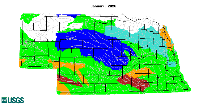
Monthly average streamflow was average to above average across the central and northern Sandhills, including the Niobrara, Elkhorn and Loup River Basins. Average to below average streamflow was indicated across the southeast panhandle and southwest Nebraska, including the Platte River Basin, and Frenchman Creek Basin. Lakes and rivers were ice free.
| Monthly Average Streamflow |
 |
|
Streamflow Mapping provided by the USGS |
Precipitation so far this water year, since October 1, 2024, was much below normal. Precipitation ranged from 1 to 5 inches. These values are from 40 percent to 80 percent of normal across north central and central Nebraska, to 80 to 110 percent of normal across portions of southwest Nebraska.
| Nebraska Percent of Normal Precipitation since October 1 |
Nebraska Precipitation since October 1 |
 |
 |
| Precipitation Maps from the High Plains Climate Center | |
Water temperatures in the tropical Pacific Ocean remain slightly below average, with weak La Nina conditions. The outlook indicates a 66 percent chance that neutral conditions may develop March through May. For the late winter and spring months, this weather pattern will typically favor near average temperatures with near to slightly below average precipitation across the Central Plains.
According to the Climate Prediction Center, as of March 13th, the latest 8 to 14 day outlook calls for above average temperatures with near average precipitation.
| 8 - 14 Day Temperature Outlook | 8 - 14 day Precipitation Outlook |
 |
 |
The latest 30 day outlook for March calls for near average temperatures and precipitation.
| Temperature Outlook | Precipitation Outlook |
 |
 |
According to the Climate Prediction Center, the latest 90 day outlook for March, April, and May indicates near average temperatures with near to below average precipitation going into this spring.
| Three Month Temperature Outlook | Three Month Precipitation Outlook |
 |
 |
More Outlooks are available at the Climate Prediction Center Temperature and Precipitation Outlooks webpage
If you have any questions or comments about this spring flood and water resource outlook please contact,
Kenneth Roberg
North Platte HSA Focal Point
National Weather Service
5250 East Lee Bird Drive
North Platte, NE 6910
Telephone 308-532-4936
E-mail kenneth.roberg@noaa.gov