National Weather Service United States Department of Commerce

Heat Continues for the East and South-Central U.S.; Strong to Severe Storms Across the Mid-Atlantic and Northeast

The extremely dangerous heat wave continues across the East Coast and much of the South-Central U.S. today. Record high temperatures are expected for some areas especially across the Mid-Atlantic where extreme heat risk conditions reside. There is a Slight Risk (level 2 of 5) of severe thunderstorms today for the northern Mid-Atlantic into portions of southern New England. Read More >


Valentine Independence Day Climatology


Independence Day occurs on the Fourth of July every year, often celebrated by many people gathering to watch firework displays. Weather plays a big part to the enjoyment of a firework display, in dry conditions the fireworks could start fires and in rainy conditions the fireworks will not work. The National Weather Service in North Platte, as for many years, will be monitoring the weather and advising Western and North Central Nebraska the potential dangers of firework displays. Fireworks have been around for centuries but the first Weather observations to be taken on the Fourth of July at Valentine was in 1889. This study compares the weather reported on July 4 over recorded history.


INDEPENDENCE DAY IN VALENTINE
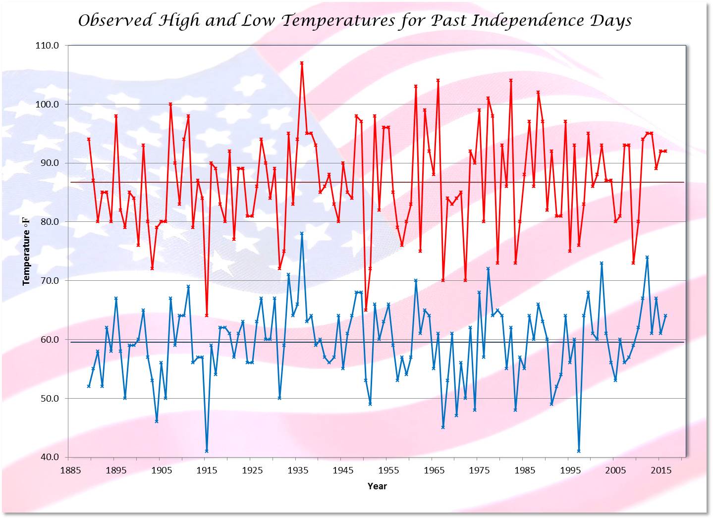
PERIOD OF RECORD 128 YEARS: 1889-2016

TEMPERATURE DATA

Highest 107 degrees (1936)
Lowest 41 degrees (2 times)
(1915 & 1997)
Lowest Maximum 64 degrees (1915)
Highest Minimum 78 degrees (1936)
Average High 86.7 degrees
Average Low 59.5 degrees
30 Year Normal High 88 degrees
30 Year Normal Low 59 degrees
Average Temperature Range 27.2 degrees
Largest Range
between High and Low
43 degrees (2 times)
High 104, Low 61 (1966)
High 92, Low 49 (1991)
Smallest Range
between High and Low
8 degrees
High 73, Low 65 (1979)


High Temperature by 10 Degree Ranges

60s 70s 80s 90s 100s
2 19 58 42 7
1.6% 14.8% 45.3% 32.8% 5.5%


Low Temperature by 10 Degree Ranges
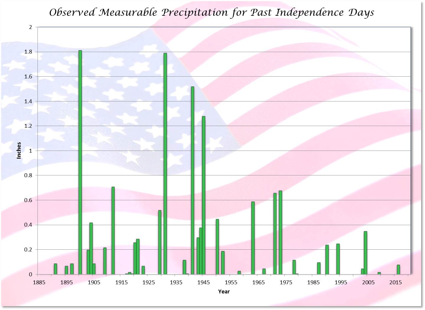
40s 50s 60s 70s
9 51 62 6
7.0% 39.8% 48.4% 4.7%


PRECIPITATION DATA

Maximum Precipitation 1.81 inches (1900)
Number of Times Precipitation 53 Occurrences or 41.4%
Number of Times
Measurable Precipitation
(more than a Trace)
39 Occurrences or 30.5%
Number of Times No Precipitation 75 Occurrences or 58.6%


DAILY WEATHER SUMMARIES PAST 5 INDEPENDENCE DAYS

Date High Low Precip Remarks
2012 95 74 0.00  Mostly sunny
2013 95 61 T  Partly cloudy, late afternoon thundershower
2014 89 67 0.00  Mostly sunny, breezy afternoon (peak gust
 32 mph)
2015 92 61 0.00  Mostly sunny
2016 92 64 0.08  Mostly sunny, early morning thundershower


YEAR BY YEAR WEATHER FOR PAST INDEPENDENCE DAYS
CLICK ON GRAPH FOR LARGER IMAGE

Temperatures - High & Low with Averages

Precipitation

ALSO VISIT NORTH PLATTE INDEPENDENCE DAY CLIMATOLOGY

For more holiday climate studies see the main menu
Holiday Climate Studies for North Platte and Valentine


  Page composition by
Matthew Masek
  Update includes 2016