Overview
|
Severe thunderstorms developed along the Kansas and Nebraska border near highway 83 early in the afternoon of Thursday May 12, 2022. The storms quickly intensified and developed into a line that moved rapidly northward through eastern Nebraska, northwestern Iowa, eastern South Dakota, and into central Minnesota. Wind speeds of 80 to 100 mph brought significant straight line wind damage throughout eastern Nebraska. |
 Severe Wind, Hail and Tornado Reports |
Wind:
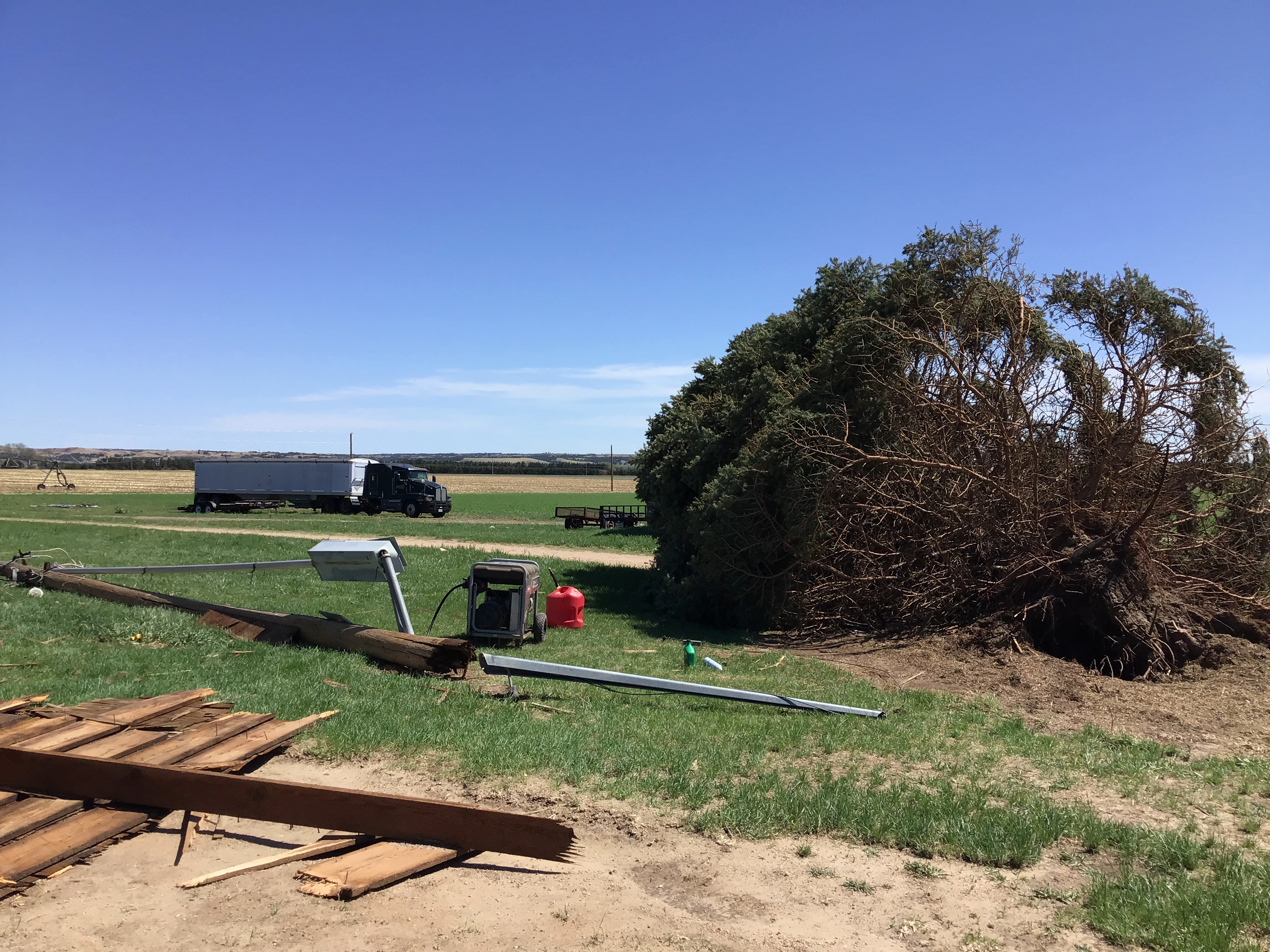
A line of severe thunderstorms with destructive straight line winds of 80 to 100 mph impacted portions of Custer, Garfield, Wheeler, Holt, and Boyd counties. Widespread tree damage was observed along with damage to buildings. The city of Burwell was especially impacted on it's southeast side where numerous buildings were damaged. Below are selected photos from the damage survey conducted on Friday, May 13, 2022. The result of the survey is preliminary as the National Weather Service continues to investigate further reports. If you have storm footage or further damage reports from this event, please relay your report to the National Weather Service in North Platte.
Selected Photos From Burwell and Near Ericson
 |
 |
 |
 |
| Irrigation pivot blown down by straight line thunderstorm winds near Burwell, NE | Roof blown off an out building by straight line thunderstorms winds near Burwell, NE | Damage to the grandstand at Garfield county fairgrounds from straight line thunderstorm winds (1) | Damage to the grandstand at Garfield county fairgrounds from straight line thunderstorm winds (2) |
 |
 |
 |
 |
| Pole driven into a house by straight line thunderstorm winds near Burwell, NE | Tree and power pole blown down by straight line thunderstorm winds near Burwell, NE | Out building blown down by straight line thunderstorm winds near Burwell, NE | A line of power poles blown down by straight line thunderstorm winds between Burwell, NE and Ericson, NE |
Storm Reports
PRELIMINARY LOCAL STORM REPORT...SUMMARY
NATIONAL WEATHER SERVICE NORTH PLATTE NE
558 PM CDT THU MAY 12 2022

..TIME...   ...EVENT...      ...CITY LOCATION...     ...LAT.LON...
..DATE...   ....MAG....      ..COUNTY LOCATION..ST.. ...SOURCE....
            ..REMARKS..

0226 PM     TSTM WND GST     9 SSW MASON CITY        41.10N 99.38W
05/12/2022  E60.00 MPH       CUSTER             NE   PUBLIC

            REPORT VIA SOCIAL MEDIA, WINDS AT LEAST 60 MPH WIND.

0228 PM     HAIL             1 S ANSLEY              41.27N 99.38W
05/12/2022  M1.50 INCH       CUSTER             NE   PUBLIC

0253 PM     TSTM WND GST     2 S BURWELL             41.75N 99.13W
05/12/2022  E70.00 MPH       GARFIELD           NE   EMERGENCY MNGR

0255 PM     TSTM WND DMG     BURWELL                 41.78N 99.13W
05/12/2022                   GARFIELD           NE   CO-OP OBSERVER

            WEST SIDE OF TOWN THERE WAS A HORSE BARN 15 BY 15 FOOT
            THAT WAS BLOWN OFF. THERE WERE 25 TREES UPROOTED. ROOF
            BLOWN OFF THE GRAND STAND AT THE FAIRGROUNDS.

0305 PM     TSTM WND GST     16 NNE BURWELL          41.99N 99.02W
05/12/2022  E60.00 MPH       GARFIELD           NE   PUBLIC

            ESTIMATED 60 MPH WIND GUST WITH 12 INCH DIAMETER TREE
            DOWN.

0305 PM     HAIL             16 NNE BURWELL          41.99N 99.02W
05/12/2022  E1.00 INCH       GARFIELD           NE   PUBLIC

0315 PM     TSTM WND GST     5 W NAPER               42.96N 99.20W
05/12/2022  E60.00 MPH       BOYD               NE   PUBLIC

            ESTIMATED 60 MPH WINDS WITH HALF INCH HAIL.

0329 PM     TSTM WND GST     EWING                   42.26N 98.34W
05/12/2022  M88.00 MPH       HOLT               NE   MESONET

            MEASURED 88 MPH WIND GUST

0330 PM     TSTM WND DMG     12 E ONEILL             42.46N 98.41W
05/12/2022                   HOLT               NE   EMERGENCY MNGR

            *** 1 INJ *** DELAYED REPORT OF A SEMI TRUCK ROLLED OVER
            BY THUNDERSTORM WINDS. MOTOR VEHICLE INJURY OCCURRED.

0420 PM     DUST STORM       3 E SUTHERLAND          41.16N 101.07W
05/12/2022                   LINCOLN            NE   EMERGENCY MNGR

            MULTI VEHICLE ACCIDENT ON HWY 30 NEAR MILE MARKER 160 DUE
            TO ZERO VISIBILITY IN BLOWING DUST

0435 PM     NON-TSTM WND GST 4 E NORTH PLATTE        41.13N 100.69W
05/12/2022  M69.00 MPH       LINCOLN            NE   ASOS

0441 PM     NON-TSTM WND GST 4 W NORTH PLATTE        41.13N 100.85W
05/12/2022  M70.00 MPH       LINCOLN            NE   ASOS

0444 PM     NON-TSTM WND GST 6 SW ARNOLD             41.36N 100.27W
05/12/2022  E75.00 MPH       LINCOLN            NE   PUBLIC

            ESTIMATED 75 MPH WINDS.

0528 PM     NON-TSTM WND GST VALENTINE               42.87N 100.55W
05/12/2022  M60.00 MPH       CHERRY             NE   ASOS
 |
Media use of NWS Web News Stories is encouraged! Please acknowledge the NWS as the source of any news information accessed from this site. |
|

