| 2014 TOP 5 WEATHER EVENTS FOR WESTERN AND NORTH CENTRAL NEBRASKA |
|||||||||||||||||||||||||||||||||||||||||||||||||||||||
| Severe thunderstorms with tornadoes, large hail and damaging winds were sandwiched in between late spring and early fall snows across Western and North Central Nebraska. In addition, unseasonably cold temperatures occurred in November with numerous record lows observed across the area. Abundant rainfall occurred during spring, which erased drought conditions which had been in place since the early summer of 2012. The wet spring was followed by one of the driest July's on record with several stations recording well below normal precipitation. Moisture returned in August with near normal precipitation continuing into the fall months. The following are the top 5 weather events across Western and North Central Nebraska for 2014, as determined by the staff at the National Weather Service Office in North Platte. |
|||||||||||||||||||||||||||||||||||||||||||||||||||||||
|
An isolated thunderstorm developed during the late afternoon hours on July 9th in northern Lincoln County. The thunderstorm quickly became severe as it moved over North Platte. Hail from golf ball up to baseball size was reported in the city of North Platte with numerous reports of damage to roofs and vehicles. Due to the extensive number of insurance claims, mobile insurance units were setup in the city. The severe thunderstorm continued to track south through the Lake Maloney State Recreational Area dropping hail up to baseball size and causing damage to residential property. The storm continued to track south through the town of Wellfleet, again producing hail up to baseball size. 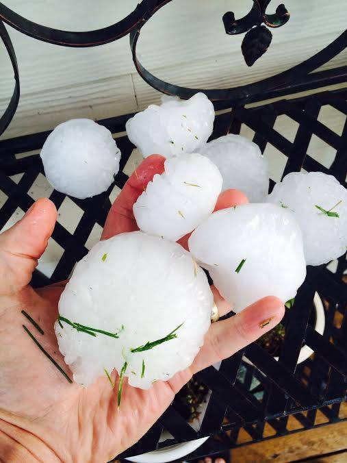 Image of Hail Stones, photo credit Ryan Knutsvig
|
|||||||||||||||||||||||||||||||||||||||||||||||||||||||
|
After well above precipitation in June across Western and North Central Nebraska, well below normal precipitation occurred in July across the region. For North Platte, 8.75 inches of rain fell in June. This led to the 2nd wettest June on record for North Platte dating back to 1875. July recorded a meager 0.14 inches of rain at Lee Bird Field, making it the driest July on record. At Valentine, precipitation for June totaled 8.63 inches making it the wettest June on record dating back to 1889. The wet June was followed by a dry July which saw a meager 0.58 inches of rainfall at Miller Field. The 0.58 inch total for July 2014 will go down as the 9th driest on record for Valentine. For Imperial, June precipitation totaled 7.93 inches which was the 5th wettest June on record dating back to 1893. July had 1.50 inches of rain at Imperial which was the 22nd driest July on record. June precipitation for Broken Bow tallied 7.27 inches making it the 11th wettest on record. Precipitation for July was 1.70 inches, and was the 30th driest on record for Broken Bow. A summary of precipitation and monthly ranks for selected cooperative stations for June and July is given below. Stations were selected if they either had their top 10 wettest June’s on record or their 10 driest July’s on record.
|
|||||||||||||||||||||||||||||||||||||||||||||||||||||||
|
On Monday June 16th a strong storm system was taking shape in the Pacific Northwest. Well ahead of this system, a warm and humid atmosphere was in place across much of central and eastern Nebraska thanks to strong southerly winds bringing moisture originating from the Gulf of America. By Monday afternoon, one piece of the storm system out west was approaching the plains from the southwest. Plenty of sunshine through the afternoon, combined with the plentiful moisture, allowed a very unstable airmass to develop across much of the area. As a boundary separating dry air further west from the more moist air further east surged into North Central Nebraska, isolated strong to severe thunderstorms developed over Northern Custer and Southern Loup counties by late afternoon. One of these thunderstorms, a specific type of thunderstorm called a supercell, intensified rapidly and moved across highway 183 between Sargent and Taylor and produced a brief tornado north of Sargent in open country. The storm continued to intensify and moved along highway 91 between Taylor and Burwell, and eventually produced several tornadoes as it approached and moved past the town of Burwell. One of the tornadoes, reported as a large wedge tornado by storm chasers, just missed the town of Burwell and produced up to EF-2 damage from 1 mile north of Burwell to 10 miles east-northeast of the town. In this area, tree trunks were snapped, power poles were destroyed, and a number of outbuildings damaged or destroyed as well. Thankfully no injuries were reported with any of the tornadoes. By late evening, six separate tornado touchdowns were reported along a path 23 miles long from northeast Custer County to southeastern Garfield County. The EF-2 damage produced by the strongest tornadoes correlated to wind speeds up to 130 mph.
|
|||||||||||||||||||||||||||||||||||||||||||||||||||||||
|
A strong low pressure system moved across the area during the second week of May. Snow in May does happen across Western and North Central Nebraska; however it is rare to occur after the first week of the month. The last time widespread snow was observed was in 2008 but this was on the second of the month. This year, snow was reported on the 12th of May.
Four months later, in September, a rare strong cold front brought arctic air to the region. During the evening hours of the 12th as the precipitation was ending a brief changeover to snow occurred across the southern sandhills and portions of southwest Nebraska. Not all areas recorded snow, however those that did, recorded the earliest snowfall on record. This broke the previous earliest snowfall of September 12, which was set in 1989. |
|||||||||||||||||||||||||||||||||||||||||||||||||||||||
|
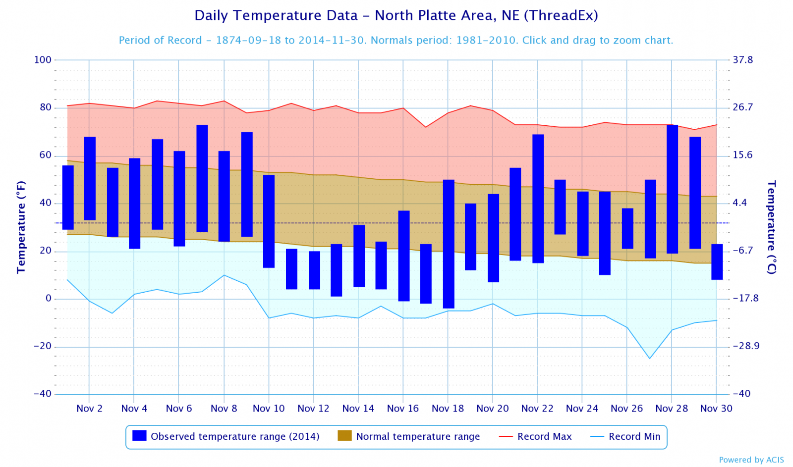
November 2014 across Nebraska was colder than normal thanks to a strong cold snap that impacted the area from the 10th through the 17th. After temperatures in the 60s and 70s the first week of the month, a strong arctic cold front moved across the state dropping temperatures significantly. This airmass remained in place for more than a week, which led to most of Western and North Central Nebraska observing temperatures that failed to rise above freezing for 7 consecutive days. Highs through this period were generally in the 20s, while lows dropped into the single digits above zero to low teens below zero. Normal highs and lows for this period were around 50 and the low 20s respectively. There were instances where daily highs were colder than the normal low temperature. Cooler than normal temperatures persisted through the 21st of the month. At Valentine, three record low temperatures were broken during this cold snap. These record lows were the following:
Because of the persistent cold temperatures, abundant ice was able to form on area rivers which in turn caused ice jams to develop in some locations. The ice jamming was most notable along the North Platte River near Lewellen, the South Platte River at North Platte, and the North Loup River near Taylor. These ice jams caused high river levels, but only minor low land flooding was observed.
|
 |
Page composition by Matt Masek, Chris Buttler, Jessica Brooks, John Stoppkotte & Kenny Roberg |
 |