While the frequency of extreme winter weather events is relatively small in the ArkLaMiss region, we do see our fair share of winter events every year. Winter weather can cause significant property damage, injury, and even death. With the start of each new season, preparation is the key to lessening the dangers and hazards associated with winter weather.
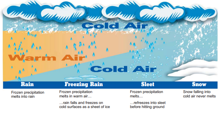
What are the differences between freezing rain, sleet, and snow???
The challenges of winter weather forecasting go beyond predicting when it will snow or how much snow will fall. At times, determining the type of precipitation is an even bigger forecast challenge, especially in the South where warmer air can reside further up in the atmosphere! Precipitation type with winter weather is largely related to the temperature profile in the atmosphere (basically between the ground and ~ 20K feet up). Typically, it gets colder as you go up in elevation but sometimes there can be a “warm layer” of air that gets wedged between the ground and the clouds. This will have an effect on the melting/freezing processes of precipitation. Refer to the graphic below that explains how you can get freezing rain versus sleet versus snow or just all rain.
What is Wind Chill?
Wind chill is the the air temperature the skin feels when it is exposed to the wind. The wind chill temperature is always lower than the actual air temperature. The wind chill is dependant on air temperature and wind speeds with the colder the air temperature and the higher the wind speed, the colder the wind chill. Exposure to very low wind chills will allow for frostbite to take effect in a much shorter amount of time than higher wind chills.

Local Winter Weather Products and Criteria
| Product | Criteria |
| Winter Storm Watch | At least a 50% chance for snow accumulations of 2"+ within 12 hours OR ice/freezing rain accumulations of 1/4"+ during a 12-24 hour period OR sleet accumulations of 1/2"+ in a 12-24 hour period OR situations in which criteria may not be met but impacts may still be significant. in the next 12 to 36 hours. |
| Winter Weather Advisory | Snow, sleet, and/or freezing rain events that are of significance to the public but do not constitute a serious enough threat to life and property to warrant a warning. |
| Wind Chill Advisory | Wind chill temperatures between -10°F and 9°F with wind speeds greater than or equal to 10 mph. |
| Winter Storm Warning | 80% confidence within the next 24 hours for snow accumulations of 2"+ within 12 hours OR ice/freezing rain accumulations of 1/4"+ during a 12-24 hour period OR sleet accumulations of 1/2"+ in a 12-24 hour period OR situations in which criteria may not be met but impacts may still be significant. |
| Ice Storm Warning | 80% confidence within the next 24 hours for ice/freezing rain accumulations of 1/4"+ during a 12-24 hour period AND/OR sleet accumulations of 1/2"+ in a 12-24 hour period with very little or no snow accumulation. |
| Wind Chill Warning | Wind chill temperatures below -10°F with wind speeds greater than or equal to 10 mph. |
| Freeze Warning | Temperatures at or below 32°F for at least 1 to 2 hours during a climatalogically significant time of the year (first freeze of the fall, a freeze soon after vegetation has budded/bloomed in the spring, a freeze during the growing season) |
|
Winter Weather Safety Tips
|


 Vehicle Preparedness and Safety
 Dressing for the Weather
 Preparing Your Home