NWS Jackson Hazardous Weather Outlook/Threat-Based Graphics
The Hazardous Weather Outlook (HWO) is designed to be a "heads up" to expected hazardous weather and its potential impact for the seven-day outlook period. It provides a first stop for users to find information on the potential for hazardous weather including timing, location, and impact. In conjunction with a text Hazardous Weather Outlook product, NWS Jackson produces coinciding images to provide a graphical depiction of threats, timing, and impacts. The text Hazardous Weather Outlook product is routinely issued twice a day - once during the early morning and again during the afternoon, and it is updated as needed. The issuance of the threat based graphics is contingent upon the existence of hazards in the upcoming forecast. Hazardous weather is defined as a meteorological or hydrologic event which has a significant chance of creating a harmful impact on people, property, or the economy.
The following hazards are included in the NWS Jackson HWO/graphics system:
Hazardous Weather Outlook Text Format
Bullets listed at beginning of each HWO segment provide readers with a quick assessment of the “what” and “when” in the Day 1 period. For example:
.DAY ONE...TONIGHT AND THURSDAY

FLOODING
THREAT…Extreme
TIMING…Tonight

SEVERE THUNDERSTORMS
THREAT…Enhanced
TIMING…Late Tonight and Thursday Morning

FOG
THREAT…Limited
TIMING…3 AM to 10 AM
Information for the Days 2-7 period will be more general and will not require bullets, but threat legend information will be given. Threat levels for hazards expected over the next seven days are defined at the bottom of the HWO text product. For example:
…THREAT LEGENDS…

*FOG*
Extreme...Widespread fog with near zero visibilities
Significant...Fog with visibilities less than or equal to ¼ mile likely
Elevated...Fog with visibilities less than or equal to 1/4 mile possible
Limited...Patchy areas of fog with visibilities less than or equal to 1/4 mile

*FLOODING*
Extreme…Confident in significant flooding
Significant…Significant flooding possible
Elevated…Confident in flooding
Limited…Flooding possible
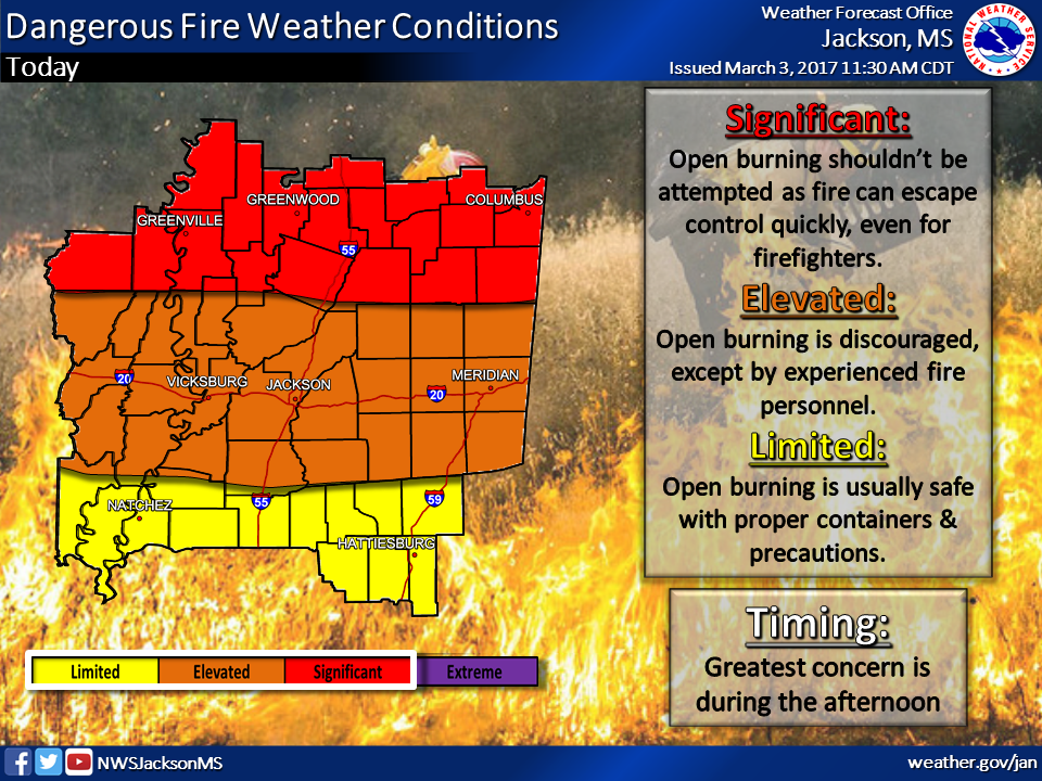
Threat-Based Graphic Example
Hazard Category Definitions
With the exception of severe thunderstorms and tornadoes (which use the Storm Prediction Center scale), the color scale, categories, and definitions are based on feedback from our partners (including media, emergency managers, and social scientists). The threat levels (extreme, significant, elevated, and limited) are designated based on forecast confidence and potential impact.
|
Severe Thunderstorms/Tornadoes
|
|
|
Hazard Level
|
Description
|
|
High
|
Significant severe expected
|
|
Moderate
|
Severe storms expected; Significant severe possible
|
|
Enhanced
|
Severe storms expected
|
|
Slight
|
Severe storms possible
|
|
Marginal
|
Isolated severe storms possible
|
|
Excessive Heat
|
|
|
Hazard Level
|
Description
|
|
Extreme
|
Maximum heat index greater than 110°F for 3+ days and/or high temperature greater than 107°F
|
|
Significant
|
Maximum heat index greater than 110°F and/or high temperature greater than 105°F
|
|
Elevated
|
Maximum heat index 106°F to 110°F and/or high temperature greater than 103°F
|
|
Limited
|
Maximum heat index near 105°F and/or high temperature greater than or equal to 100°F
|
|
Fire Danger
|
|
|
Hazard Level
|
Description
|
|
Extreme
|
Conditions well in excess of Red Flag Warning criteria with strong wind gusts greater than 40 mph. Fires will spread very quickly and wildfires are common. Fire control is very difficult, even for experienced firefighters.
|
|
Significant
|
Conditions meet minimum Red Flag Warnings criteria. Open burning should not be attempted as fires can quickly escape and become very difficult to control, even for experienced firefighters.
|
|
Elevated
|
Any open burning is discouraged due to increased wind, lower humidity, and recent dry conditions, except by fire personnel. Fires escape control more easily and containment is difficult for fire personnel.
|
|
Limited
|
Extra caution is advised with open burning. Heed local burn bans when in effect.
|
|
Flooding
|
|
|
Hazard Level
|
Description
|
|
Extreme
|
Confident in significant flooding
|
|
Significant
|
Confident in flooding, Significant flooding possible
|
|
Elevated
|
Confident in flooding
|
|
Limited
|
Flooding possible
|
|
Fog
|
|
|
Hazard Level
|
Description
|
|
Extreme
|
Widespread fog with near zero visibilities
|
|
Significant
|
Fog with visibilities less than or equal to 1/4 mile likely
|
|
Elevated
|
Fog with visibilities less than or equal to 1/4 mile possible
|
|
Limited
|
Patchy areas of fog with visibilities less than or equal to 1/4 mile
|
|
Frost/Freeze
|
|
|
Hazard Level
|
Description
|
|
Extreme
|
Hard freeze (less than or equal to 28°F) during the growing season with catastrophic damage to unprotected vegetation
|
|
Significant
|
Freeze expected (less than or equal to 32°F for 3 hours or more during the growing season with significant damage to unprotected vegetation
|
|
Elevated
|
Frost expected during the growing season with damage to unprotected vegetation. This may include temperatures less than 32°F for 1-2 hours
|
|
Limited
|
Patchy frost during the growing season with minor damage to unprotected vegetation
|
|
Hard Freeze
|
|
|
Hazard Level
|
Description
|
|
Extreme
|
Likely lows below 10°F and highs below 32°F
|
|
Significant
|
Likely lows below 15°F and highs below 32°F
|
|
Elevated
|
Likely lows below 20°F and highs near or below 32°F
|
|
Limited
|
Possible lows below 20°F and highs near or below 32°F
|
|
Ice Accumulation
|
|
|
Hazard Level
|
Description
|
|
Extreme
|
Roads impassable and widespread power outages likely
|
|
Significant
|
Dangerous travel conditions and numerous power outages possible
|
|
Elevated
|
Difficult travel conditions and sporadic power outages possible
|
|
Limited
|
Light icing of bridges and overpasses
|
|
Snow Accumulation
|
|
|
Hazard Level
|
Description
|
|
Extreme
|
Roads impassable and widespread power outages likely
|
|
Significant
|
Dangerous travel conditions and numerous power outages possible
|
|
Elevated
|
Difficult travel conditions and sporadic power outages possible
|
|
Limited
|
Bridges may be snow-covered
|
|
Gradient/Non-Thunderstorm Winds
|
|
|
Hazard Level
|
Description
|
|
Extreme
|
Sustained winds 50 mph or greater or wind gusts 65 mph or greater
|
|
Significant
|
Sustained winds 40-49 mph or wind gusts 58-64 mph
|
|
Elevated
|
Sustained winds 30-39 mph or wind gusts 45-57 mph
|
|
Limited
|
Sustained winds 20-29 mph or wind gusts 30 to 44 mph
|
|
Wind Chill Danger
|
|
|
Hazard Level
|
Description
|
|
Extreme
|
Wind chills lower than -14°F
|
|
Significant
|
Wind chills from -5°F to -14°F
|
|
Elevated
|
Wind chills from -5°F to 5°F
|
|
Limited
|
Wind chills from 5°F to 9°F
|
|
Tropical - Flooding Rain Threat
|
|
|
Hazard Level
|
Description
|
|
Extreme
|
Potential for devastating to catastrophic damage from flooding
|
|
High
|
Potential for extensive damage from flooding
|
|
Moderate
|
Potential for significant damage from flooding
|
|
Elevated
|
Potential for flash flooding resulting in limited damage from flooding
|
|
Tropical - Tornado Threat
|
|
|
Hazard Level
|
Description
|
|
Extreme
|
Potential for historic tornado outbreak capable of producing devastating to catastrophic damage
|
|
High
|
Potential for outbreak of tornadoes (several strong) capable of producing extensive damage
|
|
Moderate
|
Potential for scattered tornadoes (a few strong) capable of producing significant damage
|
|
Elevated
|
Potential for isolated tornadoes capable of producing limited to locally significant damage
|
|
Tropical - Wind Threat
|
|
|
Hazard Level
|
Description
|
|
Extreme
|
Potential for winds equal to or greater than 111 mph
|
|
High
|
Potential for winds equal to or greater than 74 mph and less than 111 mph
|
|
Moderate
|
Potential for winds equal to or greater than 58 mph and less than 74 mph
|
|
Elevated
|
Potential for winds equal to or greater than 39 mph and less than 58 mph
|
Feedback
Your comments and suggestions for continued improvements to this product are welcome and can be sent to sr-jan.webmaster@noaa.gov

