February 11-20, 2021 Arctic Cold and Winter Weather Sequence
An unusually long and extreme duration of winter weather and cold sieged the Deep South, from February 11-20, 2021. During this time, multiple rounds of winter weather precipitation impacted the region, including two significant winter storms. Records for cold temperatures were also set for both duration and intensity.
This event was born from a large and persistent arctic air mass that surged south and locked in over most of the northern and central portion of the nation during the first two weeks in February. While it took some time for the arctic air to reach our area, the associated arctic cold front eventually reached the ArkLaMissDelta region during the early morning hours of Thursday, February 11th. Precipitation initially started as rain, as the temperature profile was above freezing. However, low-level cold air advection allowed the air to become marginally cold enough for freezing rain with temperatures right at or just below freezing. Given these marginal temperatures, freezing rain mainly accumulated on elevated objects including trees and powerlines, but it did not immediately freeze to the roads. The ice accumulation in the trees added up to about a quarter inch (minimum threshold for ice storm) in Bolivar and northern Sunflower counties in Mississippi. In these areas, some power outages occurred, in addition to a few travel issues and accidents as ice eventually managed to accumulate on bridges and roads after a few hours of continuous freezing rain.
February 11th Ice Accumulation Map

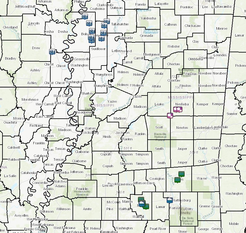
February 11, 2021 Storm Reports
By Thursday and into Friday (2/11 - 2/12), the colder air continued to surge farther southeast into the NWS Jackson forecast area. Initially, the shallow cold air drained most effectively through the flatter and lower elevation Delta region, but it eventually became deep enough to move into most of the region by the weekend. By Saturday (2/13) morning, the freezing line had pushed through much of the area. At the same time, persistent southwest flow aloft allowed warm, moist air to produce precipitation that fell into the shallow sub-freezing air as either sleet or freezing rain resulting in ice accumulation. Light freezing rain and sleet continued for locations mainly along and northwest of a Brookhaven to Forest to Macon, Mississippi line over the weekend, especially on Sunday (2/14). Hazardous travel conditions and numerous accidents were reported well before the more impactful winter storm looming on Monday. The intensity of the cold was also an increasing concern over southeastern Arkansas, northeastern Louisiana, and western and north central Mississippi where temperatures had fallen well into the 20s, and even upper teens in the upper Delta region by Sunday evening. Some locations in these areas had already been below freezing continuously since Thursday morning.
Monday’s (2/15) winter storm wasted little time getting underway as a strong upper level trough crossed the southern tier of the nation and interacted with the arctic frontal boundary. Significant amounts of freezing rain, sleet, and snow moved in before daybreak for locations along and west of the Mississippi River. By mid morning, widespread winter precipitation, accompanied by thunder at times, occurred over most of the NWS Jackson forecast area as arctic air continued surging southeast. At one point, the Jackson area observed heavy thundersleet with temperatures around 19 F, and there were even reports of small hail associated with a squall line passage! As a result of the cold air that arrived well ahead of the system, precipitation accumulated efficiently and immediately caused severe impacts to travel. In addition, power outages occurred where freezing rain was the more dominant precipitation type. The transition line from freezing rain to sleet was especially critical Monday morning, and this mostly set up to the southeast of the Natchez Trace Corridor. In a swath from around Brookhaven to Forest and Newton and northward to Philadelphia to the Golden Triangle region, the ice storm threshold (.25 inch+) was met with numerous power outages being reported. This was an especially dangerous situation given that the coldest air continued surging in as the precipitation ended and would persist for the remainder of the week. Farther east, the precipitation was initially in the form of rain with temperatures just above freezing, but even in the I-59 corridor, freezing rain was eventually reported with light ice accumulation amounts in the trees and power lines. Farther to the west, the precipitation was mostly sleet, with up to three inches accumulating from the Natchez to Jackson to Starkville areas and points west, while a greater amount of snow fell in the Delta region. In these areas, extremely hazardous travel impacts were the main concern, and the persistent cold air meant that roadways would remain treacherous for a long duration.
February 14th-16th Sleet and Snow Accumulation Map

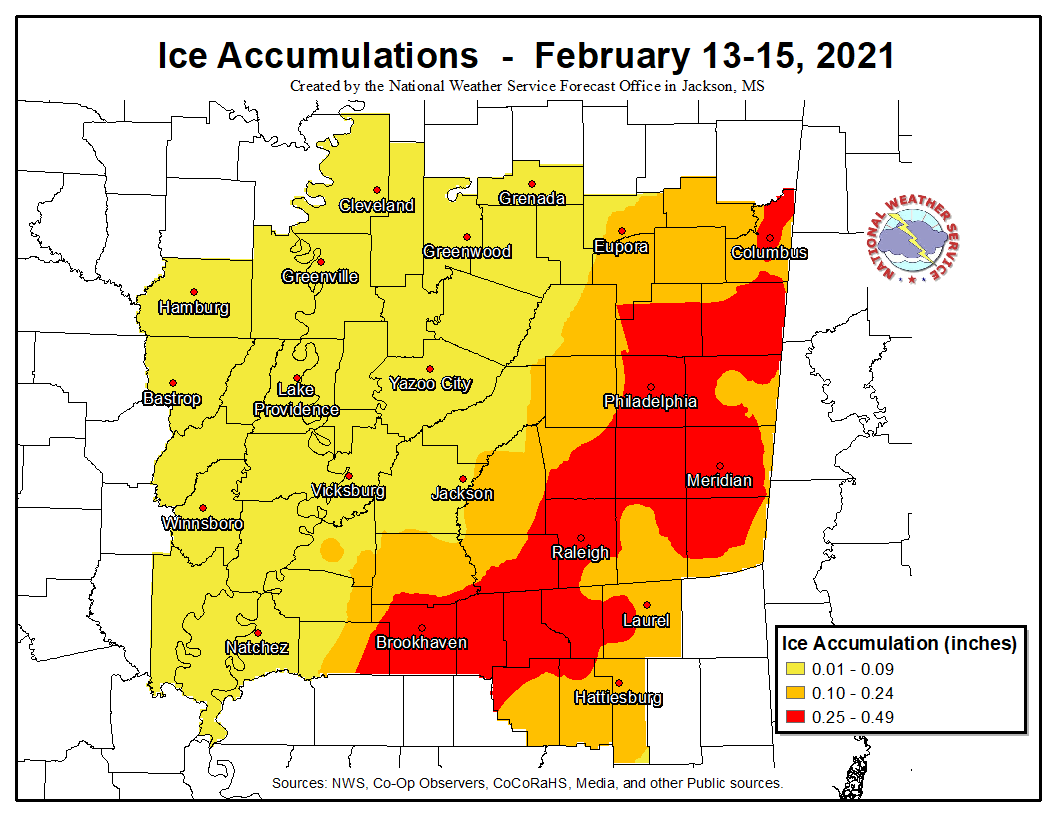
February 13th-16th Ice Accumulation Map
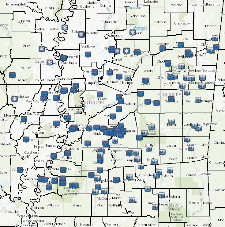
February 13-15, 2021 Storm Reports
The coldest air during the winter weather siege took hold Tuesday (2/16) as the heart of the arctic air mass was at its closest proximity. Light snow managed to fall over much of the area Tuesday, some of which led to modest accumulations across parts of northeast Mississippi. However, for the most part, this was not nearly as impactful as the precipitation from prior days. Many daily record low and low maximum temperatures were observed Monday and again Tuesday. High temperatures were near or below freezing Tuesday afternoon, in spite of full sun in some locations. In addition, gusty winds heightened the effects and impacts of the cold with wind chill readings as low as -10 F in the ArkLaMiss Delta region, and near 0 F elsewhere. While the potential for hypothermia and frostbite was significant to extreme, one of the greatest impacts of the cold was to the water systems across much of the region. In many communities, water mains froze, and the city of Jackson’s water system was decimated by the long duration of cold. While normally the winter weather and cold that occurred to this point were enough to qualify as a brutal situation for the ArkLaMiss region, there was still much more to come thanks to the persistent arctic air mass and another weather system that was fast approaching by Tuesday night.
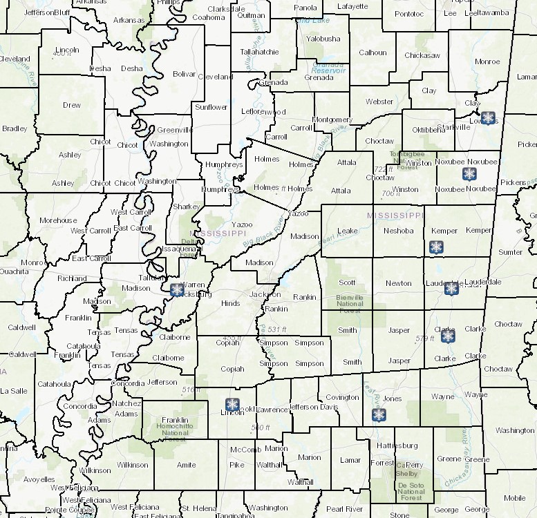
February 16, 2021 Storm Reports
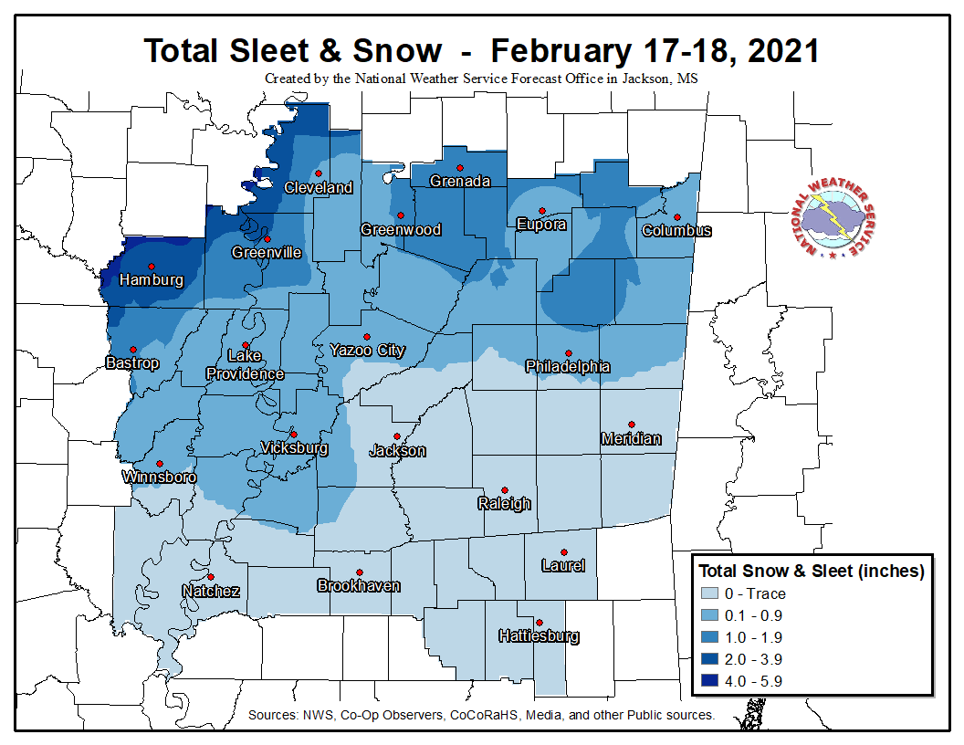
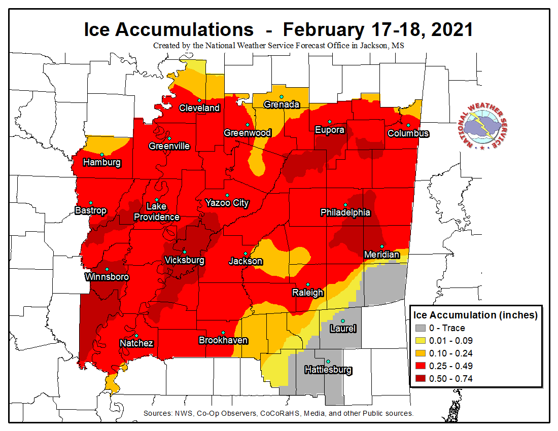
The second significant winter storm took shape and moved into western portions of the region by late Tuesday night and Wednesday (2/17) morning. Snow began to accumulate in southeast Arkansas, extreme northeast Louisiana, and upper portions of the Mississippi Delta region by daybreak Wednesday. However, the primary concern for this system was the expectation for heavy amounts of freezing rain, as much warmer air above the ground began to surge northward ahead of the approaching strong shortwave trough. With the dense, shallow arctic air remaining locked in over much of the region, freezing rain began falling before noon in much of northeastern Louisiana and southwestern Mississippi, spreading quickly northeast into central Mississippi by early afternoon. Farther north, the precipitation was mostly a mix of snow and sleet. By late afternoon, with the loss of any existing heat from the sun, freezing rain spread into much of east central Mississippi, where heavy freezing rain quickly accumulated on trees and powerlines. This resulted in power outages and travel issues as trees and powerlines fell across roads. Some people even reported dodging falling trees in desperate attempts to get home. Heavy freezing rain persisted, with trees and limbs constantly snapping through the night. The cumulative weight of snow, ice and rain caused the collapse of several home and business structures. By the time freezing rain ended, up to one inch of ice had accumulated on trees and powerlines in an area from southern portions of Northeast Louisiana to southwestern and central Mississippi, resulting in widespread severe tree damage and power outages lasting for up to two weeks.
February 17th-18th Sleet and Snow Accumulation Map
February 17th-18th Ice Accumulation Map
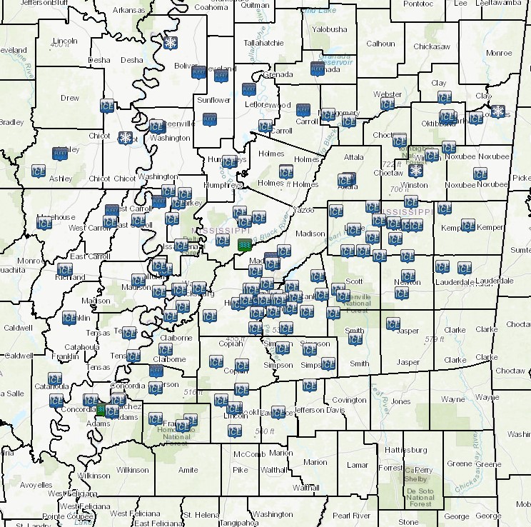
February 17-18, 2021 Storm Reports
Colder air surged back in behind the departing system Thursday (2/18) with freezing drizzle falling over the northwestern half of the NWS Jackson forecast area, further exacerbating or renewing travel impacts in this area. Additional record lows were set Thursday night with temperatures remaining below freezing for over a week by Friday (2/19) morning in portions of the upper Delta region. Although the sun would come out in full force for much of the area Friday, the cold air continued and much of the ice and snow remained until Saturday (2/20) morning. Further travel complications developed when some thawing took place Friday, which led to slushy roads refreezing Friday night. Finally, the cold air pulled out in earnest Saturday with temperatures climbing to well above freezing at all locations, and this allowed most of the snow and ice in unshaded areas to finally melt. A record long duration of measurable snow was set at the Jackson Medgar Wiley Evers International Airport Saturday (2/20) morning.
This stretch of extreme winter weather and cold will long be remembered for its relentless grip on our region.

