February 23, 2019 Tornadoes
Tornado Damage Map

Local Storm Reports
Click on the map for additional details.


Click on the location in the table for additional maps and details
| Location | Start/ End Time |
Event Type | Fatalities/ Injuries |
Path Length | Path Width |
| Lowndes County 2 SSW Artesia to 2 S Artesia |
4:53 PM - 4:55 PM |
EF-0 Tornado 85 mph |
none | 0.5 miles | 150 yards |
| Lowndes County 2 SW Columbus to 2 ESE Steens |
5:15 PM - 5:31 PM |
EF-3 Tornado 137 mph |
1 Fatality, 19 Injuries | 10 miles | 1/4 mile |
Click on map above to see entire damage point notation and damage pictures at select points.
|
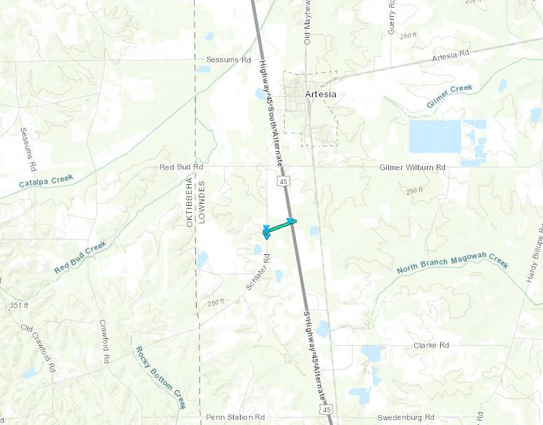
Track Summary A brief EF0 tornado developed during the evening of February 23rd along Shlater Road west of US 45, where it uprooted and snapped several softwood trees. It quickly moved northeast and crossed US 45 where it snapped softwood trees along the both sides of US 45, and caused roof loss to a mobile home and tin shed along the west side of US 45. In addition, the tin from the storage shed was lofted to the east side of US 45. Additional snapped softwood trees occurred just east of US 45 before the tornado finally lifted. |
|
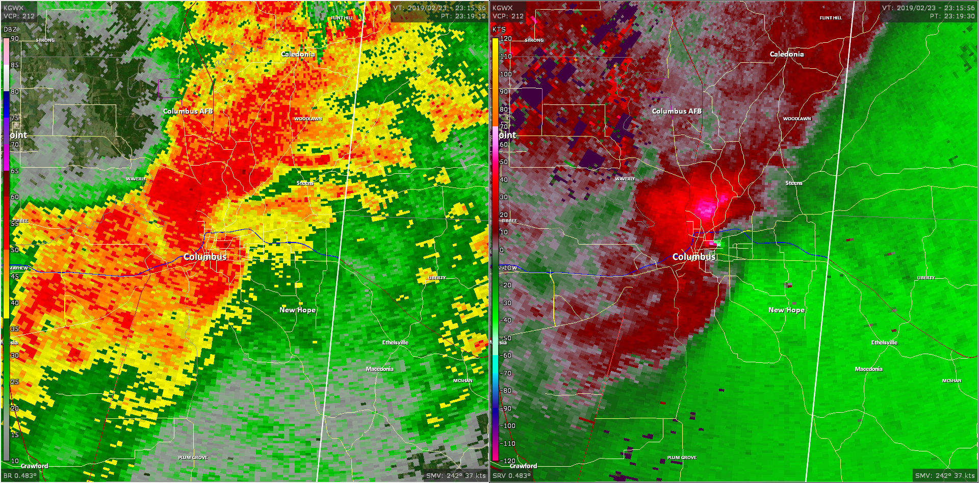
Radar Imagery
These images from the Columbus AFB Doppler radar show the storm at 4:53 pm as the tornado approached Alt US 45 south of Artesia. The image on the left shows 0.5° base reflectivity data, and the image on the right shows 0.5° storm relative velocity data. Click on the thumbnail below for a higher resolution image.
Click on map above to see entire damage point notation and damage pictures at select points.
|
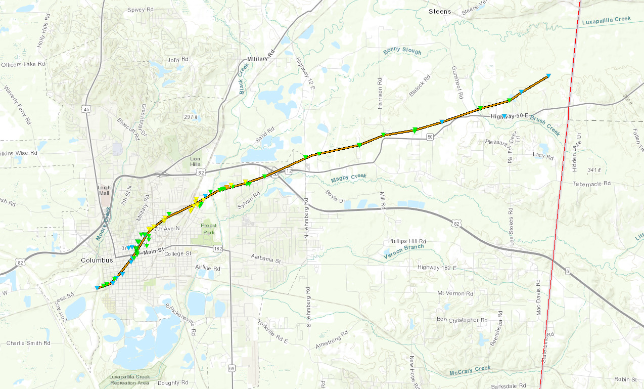
Track Summary The tornado developed along the southwest edge of Columbus, MS near 1st Street, noted by broken small hardwood tree limbs and uprooted hardwood trees, which fell atop a Voting Precinct single-story building. Minor roof damage to a nearby two story home also occurred. As the tornado tracked northeast across the eastern side of downtown Columbus, MS, it became evident that the storm had grown in strength a bit as streets became littered with uprooted and snapped hardwood and softwood trees, many of which had fallen on homes, causing significant roof damage. As the tornado moved along 9th street and College Street, damage was noted on top of a cell tower, where portions of the metal structure was evidently bent. By the time the tornado reached 12th Street and 4th Avenue, more extensive damage was noted by way of a brick fence along a single family home getting almost completely destroyed and additional snapped and uprooted hardwood trees. Wooden power lines were snapped near or at its base at 12th Street and 4th Avenue, where portions of the roof was lost at the nearby Canterbury Townhouses. Littered downed and snapped trees falling on top of homes persisted along the northeast side of downtown Columbus, and southward facing homes along Railroad Street had windows that were blown out. As the tornado continued along its northeast path, it intersected the Hunt Intermediate School along 10th Avenue and 20th Street resulting in significant damage to the roof, and blown out windows along the second floor. Across the street, the Park and Rec Center and Activities Center composed of metal and tin were blown in/collapsed on its entry side. Damage continued along Tuscaloosa Road by way of fence damage along the outskirts of a Loves Truck Stop and snapped softwood and hardwood trees behind the Loves Truck Stop. The First Pentecostal Church along Tuscaloosa Road had half of its tin roof blown off, and thus resulted in damage done to the inside of its worship area. At the intersection of Tuscaloosa Road and Conway Road, several manufactured buildings had most of their exterior walls and roofs caved in. The one fatality occurred at the intersection of Tuscaloosa Road and Gardner Street, where a structurally sound brick building collapsed and the majority of the exterior walls were destroyed. This tornado began to weaken as it neared the Alabama state line, as several softwood medium size tree limbs and softwood trees were snapped north of Highway 50. This tornado lifted just as it neared the Alabama state line. |
|
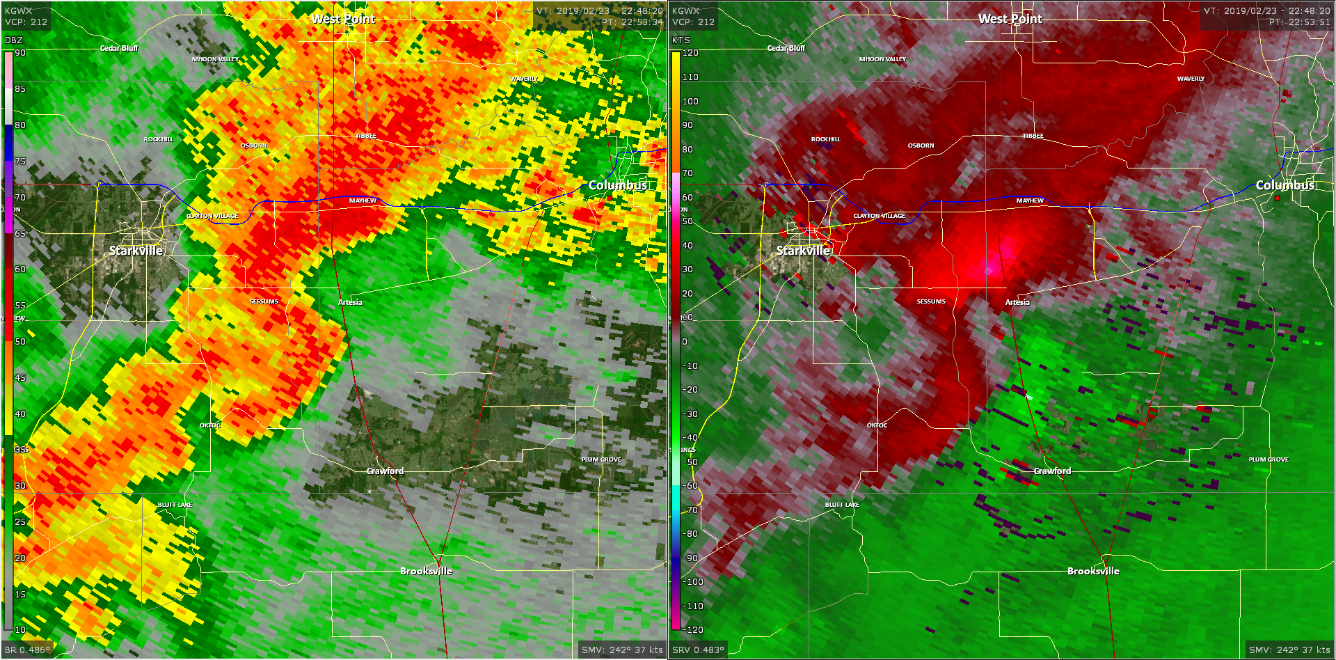
Radar Imagery
These images from the Columbus AFB Doppler radar show the storm at 5:19 pm as the tornado became most intense on the east side of Columbus. The image on the left shows 0.5° base reflectivity data, and the image on the right shows 0.5° storm relative velocity data. Click on the thumbnail below for a higher resolution image.