April 6, 2018 Severe Weather Event
Event Summary
By the early morning hours of April 6th, a strong warm front was moving onto the Gulf Coast near Louisiana and Texas. The ArkLaMiss was under a surface high building off to the east, with dewpoints in the upper 40s. As a strong low pressure developed over the southern Plains and northern Texas, the warm front lifted to the northeast by the mid-afternoon over the I-20 corridor. In response, much higher dewpoints in the mid-upper 60s moved into the area, bringing much richer moisture over most of the region. Due to the strong cold front and unstable environment, widespread thunderstorms began to develop over the northwestern portions of the Delta by mid-afternoon. These storms north of the warm front continued to train through most of the afternoon to evening, while south of the warm front supercell thunderstorms began to develop. These supercell thunderstorms moved through northeast Louisiana and central-southern Mississippi, leading to a few tornadoes touching down. In addition, as a cold front moved into ArkLaMiss Delta and southeast, a strong squall line began to move to the southeast. Along and south of the squall line, the environment was very favorable for severe weather. In total, 10 tornadoes touched down across the ArkLaMiss region, with some of the strongest having high end EF1 damage. Additionally, high moisture, a stalled frontal boundary draped west to east, and training thunderstorms with high rates of rain led to nearly 2-5 inches of rainfall. Most of this rainfall occurred across the middle Pearl River & Big Black River basins, leading to sharp rises in the rivers. This squall line moved to the south and all of the severe weather exited the region by a little after midnight on April 7th.
Tornado Damage Map

Local Storm Reports
Click on the map for additional details.


Click on the location in the table for additional maps and details below.
| Location | Start/ End Time |
Event Type | Fatalities/ Injuries |
Path Length | Path Width |
| Madison Parish 8 WNW Tallulah to 7 WNW Tallulah |
6:05 PM - 6:07 PM |
EF-0 Tornado 70 mph |
none | 0.91 miles | 25 yards |
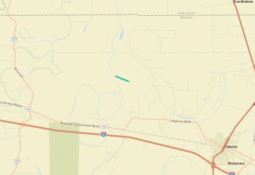
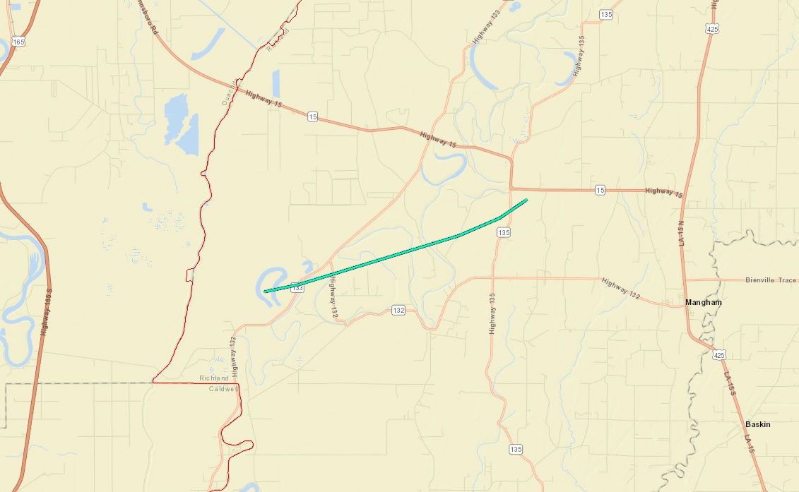
| Richland Parish 10 SSE Richwood to 5 NW Mangham |
6:40 PM - 6:53 PM |
EF-0 Tornado 75 mph |
none | 7.92 miles | 50 yards |
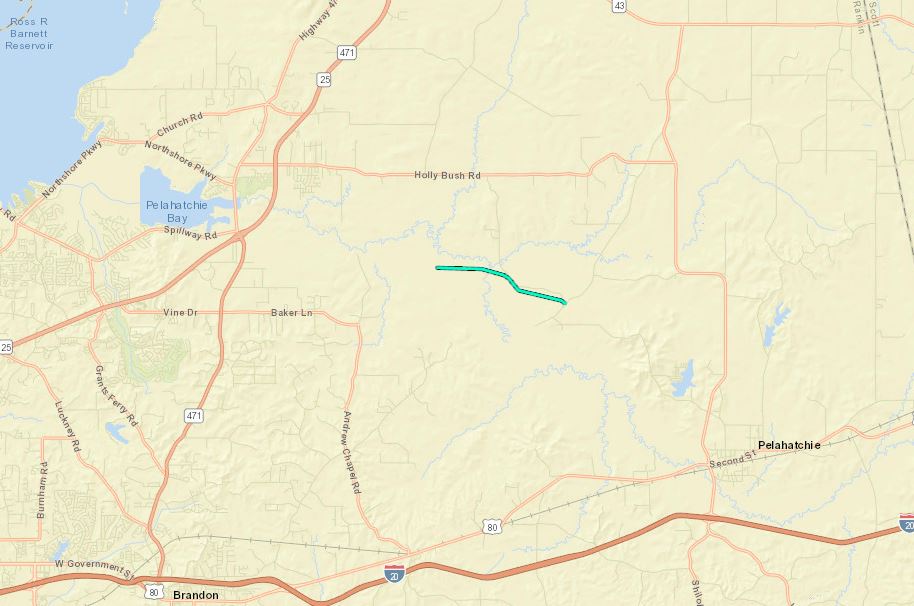
| Rankin County 6 WNW Pelahatchie to 4 NW Pelahatchie |
8:03 PM - 8:08 PM |
EF-0 Tornado 75 mph |
none | 2.75 miles | 25 yards |
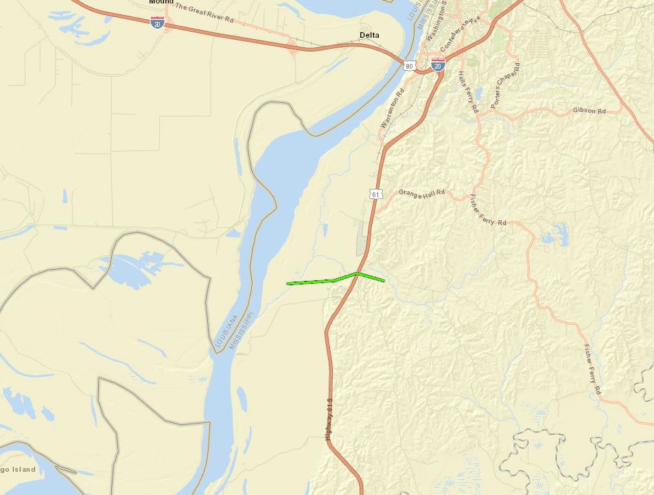
| Warren County 7 SSW Delta to 7 S Delta |
8:12 PM - 8:22 PM |
EF-1 Tornado 90 mph |
none | 2.89 miles | 75 yards |
| Claiborne County 9 SE Port Gibson to 10 SE Port Gibson |
9:27 PM - 9:29 PM |
EF-1 Tornado 90 mph |
none | 1.17 miles | 360 yards |
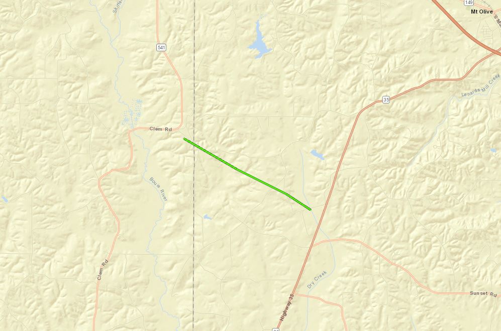
| Claiborne County 12 SE Port Gibson to 16 ESE Port Gibson |
9:32 PM - 9:40 PM |
EF-1 Tornado 110 mph |
none | 6.15 miles | 1/2 mile |
| Copiah County 17 WSW Hazlehurst to 16 WSW Hazlehurst |
9:46 PM - 9:49 PM |
EF-1 Tornado 100 mph |
none | 2.37 miles | 700 yards |
| Jefferson Davis County 3 ENE New Hebron to 7 E New Hebron |
11:01 PM - 11:09 PM |
EF-1 Tornado 95 mph |
none | 4.67 miles | 350 yards |
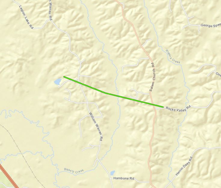
| Jefferson Davis and Covington counties 6 WSW Mount Olive to 5 SW Mount Olive |
11:18 PM - 11:23 PM |
EF-1 Tornado 105 mph |
none | 2.91 miles | 1/4 mile |
| Covington County 5 NNW Collins to 4 N Collins |
11:33 PM - 11:37 PM |
EF-1 Tornado 90 mph |
none | 1.75 miles | 125 yards |
Click on map above to see entire damage point notation and damage pictures at select points.
|
Track Summary Video shared via social media showed a brief tornado occurring over open agricultural fields in northern Madison Parish west of Bear Lake. Official NWS survey team was unable to find any damage associated with this tornado and concluded that the tornado formed and dissipated over open fields. |
|
Radar Imagery
These images from the Monroe, LA Doppler radar show the storm at 6:04 pm. The image on the left shows 0.5° base reflectivity data, and the image on the right shows 0.5° storm relative velocity data. Click on the thumbnail below for a higher resolution image.

Click on map above to see entire damage point notation and damage pictures at select points.
|
Track Summary This weak tornado began just east of Bayou Lafourche before crossing Hwy 133 where numerous large tree limbs were broken. The tornado then crossed Hwy 132 and traveled through mainly rural areas of open agricultural fields and stands of trees where the tornado reached peak intensity of 75 mph snapping a few small pine trees. The tornado crossed Hwy 135 just south of Alto downing a few more large tree limbs before dissipating over a wooded area. |
|
Radar Imagery
These images from the Monroe, LA Doppler radar show the storm at 6:45 pm. The image on the left shows 0.5° base reflectivity data, and the image on the right shows 0.5° storm relative velocity data. Click on the thumbnail below for a higher resolution image.

Click on map above to see entire damage point notation and damage pictures at select points.
|
Track Summary The tornado began in a wooded area along Pelahatchie Creek, then tracked east southeastward near Haynes Chapel Road, ending near Lake Rd. A few trees were uprooted and several large branches were snapped along the path. Powerlines were downed along Haynes Chapel Rd. |
|
Radar Imagery
These images from the Brandon, MS Doppler radar show the storm at 8:03 pm as the tornado touched down. The image on the left shows 0.5° base reflectivity data, and the image on the right shows 0.5° storm relative velocity data. Click on the thumbnail below for a higher resolution image.

Click on map above to see entire damage point notation and damage pictures at select points.
|
Track Summary This tornado began just west of the Mississippi River over a heavily wooded area before moving over Glass Road where numerous large branches and a few small trees were snapped. The tornado reached peak intensity right as it crossed Hwy 61 where multiple hardwood trees were snapped. The tornado dissipated over a wooded area just east of Hwy 61. |
|
Radar Imagery
These images from the Brandon, MS Doppler radar show the storm at 8:19 pm as the tornado reached peak intensity. The image on the left shows 0.5° base reflectivity data, and the image on the right shows 0.5° storm relative velocity data. Click on the thumbnail below for a higher resolution image.

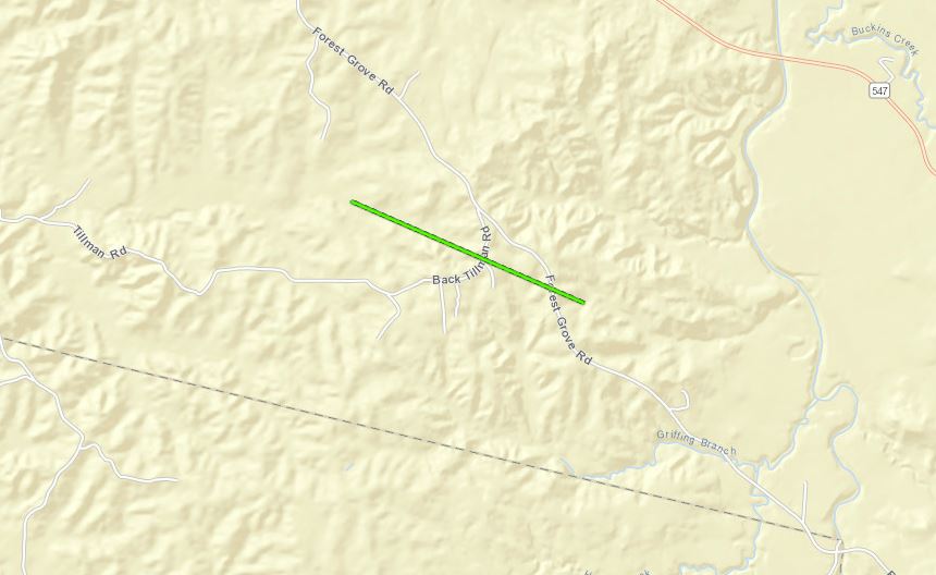
Claiborne County EF-1 #1 Tornado
Click on map above to see entire damage point notation and damage pictures at select points.
|
Track Summary This tornado touched down in a wooded area around a mile west of Tillman Road and Forest Grove Road. It caused some tree damage in the outer fringes of the circulation as it first crossed Pattison Tillman Road and northern Forrest Grove Road but most of the actual tornadic circulation touched down near the intersection of Tillman Road and Forest Grove Road. There were widespread trees and large limbs either snapped or uprooted. The tornado continued to the east-southeast before crossing Forest Grove Road. There it continued into the woods and creek basin, where the survey team was unable to reach. The circulation weakened and the tornado likely lifted as it moved in this area. |
|
Radar Imagery
These images from the Brandon, MS Doppler radar show the storm at 9:28 pm. The image on the left shows 0.5° base reflectivity data, and the image on the right shows 0.5° storm relative velocity data. Click on the thumbnail below for a higher resolution image.

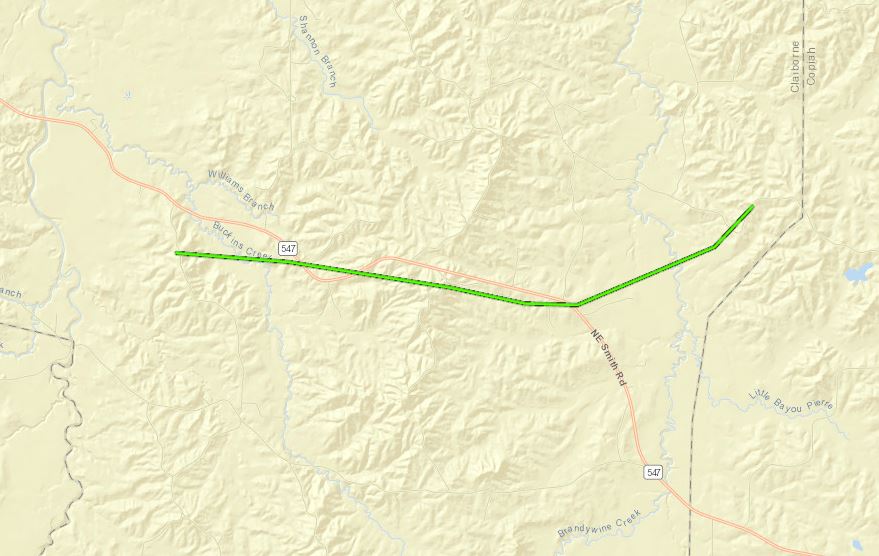
Claiborne County EF-1 #2 Tornado
Click on map above to see entire damage point notation and damage pictures at select points.
|
Track Summary The tornado touched down to the northwest of Buckins Creek basin and moved more east, beginning on Moss Down Lane. It continued along around a 3-4 mile portion of Highway 547. This tornado began to widen and caused widespread tree damage all along the path, especially along Highway 547. Hundreds of trees were snapped and uprooted and many powerlines were broken or snapped near Mt. Pleasant Road, Coleman Road and Northeast Smith Road. In addition, some homes had trees fall on them or had tin peeled back off the roof. One 18 wheeler tractor trailer was overturned as well. The tornado was the widest at this point along Highway 547 and damage reached high end EF1 levels. It continued past NE Smith Road into another creek basin, causing more widespread tree damage. It continued to Henneberry Road before lifting. |
|
Radar Imagery
These images from the Brandon, MS Doppler radar show the storm at 9:35 pm. The image on the left shows 0.5° base reflectivity data, and the image on the right shows 0.5° storm relative velocity data. Click on the thumbnail below for a higher resolution image.

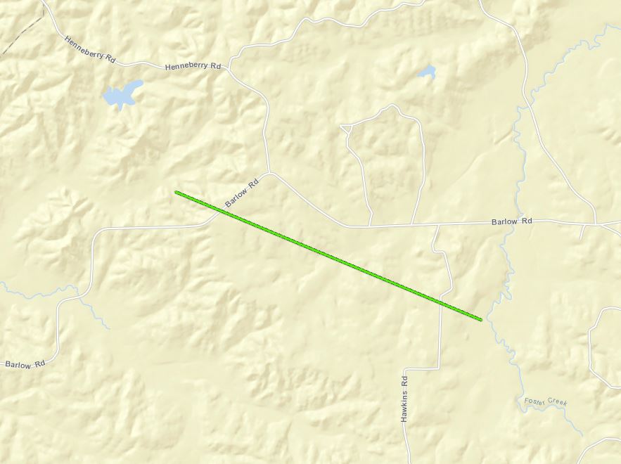
Copiah County/Barlow EF-1 Tornado
Click on map above to see entire damage point notation and damage pictures at select points.
|
Track Summary The tornado touched down along and just west of Barlow Road. It continued near the intersection of Barlow and Henneberry Road before crossing Hawkins Road. Many large limbs and trees were snapped and uprooted along the path. It continued east-southeast before crossing Hawkins Road. Here, soon after crossing into another creek basin, the tornado weakened and lifted. |
|
Radar Imagery
These images from the Brandon, MS Doppler radar show the storm at 9:47 pm. The image on the left shows 0.5° base reflectivity data, and the image on the right shows 0.5° storm relative velocity data. Click on the thumbnail below for a higher resolution image.

Click on map above to see entire damage point notation and damage pictures at select points.
|
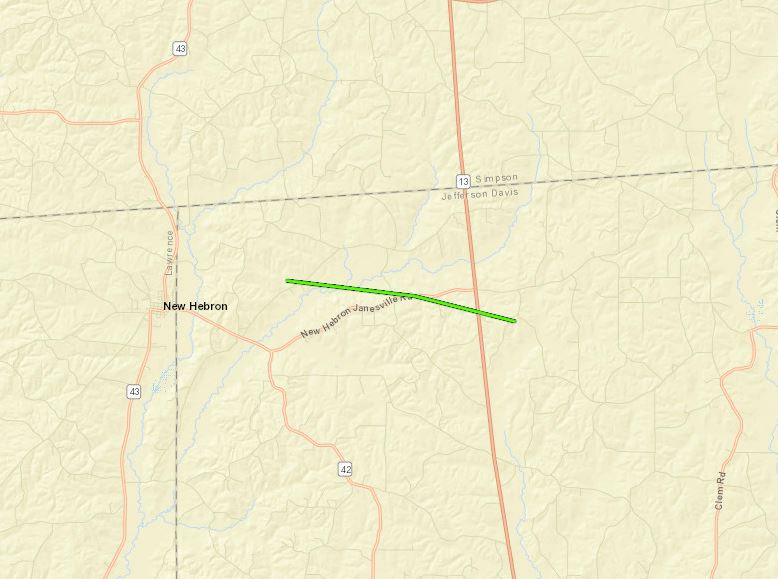
Track Summary This tornado touched down just east-northeast of New Hebron, along Old Hebron Gwinville Road. Some trees were snapped and uprooted in this area. It continued east-southeast towards Silver Swamp Road and New Hebron Janesville Road. More trees and limbs were snapped or uprooted in this area, especially along New Hebron Janesville Road. The tornado continued across Highway 13 and Dale Road, where a few large trees were uprooted in the fields and woods nearby. The tornado lifted soon after before crossing Sugar Ridge Road. |
|
Radar Imagery
These images from the Brandon, MS Doppler radar show the storm at 11:08 pm. The image on the left shows 0.5° base reflectivity data, and the image on the right shows 0.5° storm relative velocity data. Click on the thumbnail below for a higher resolution image.

Jefferson Davis/Covington EF-1 Tornado
Click on map above to see entire damage point notation and damage pictures at select points.
|
Track Summary This tornado touched down near the Jefferson Davis-Covington County line along Lucas Hollow Road. It continued southeast, crossing the Covington County Line. Some large limbs and trees were snapped and uprooted at this location. It then crossed Lucas Hollow Road again before crossing Leonard Road. A tornado debris signature was indicated on radar in these locations. The tornado uprooted and snapped many trees in this region. It also overturned a small tractor trailer on Oakvale Road and caused some minor shingle damage to a home. After crossing Oakvale Road twice, the tornado lifted soon after before crossing Highway 35. |
|
Radar Imagery
These images from the Brandon, MS Doppler radar show the storm at 11:18 pm. The image on the left shows 0.5° base reflectivity data, and the image on the right shows 0.5° storm relative velocity data. Click on the thumbnail below for a higher resolution image.

Click on map above to see entire damage point notation and damage pictures at select points.
|
Track Summary This tornado touched down southeast of Mount Olive just to the west of Linda Sanford Lane, near the intersection of William Warren Road. Some trees were snapped and uprooted just west and along William Warren Road. It then continued east-southeast before crossing Salem Church Road. Some large limbs were snapped in this area. It then crossed Rocky Valley Road, where some limbs were snapped and a few pine trees were uprooted. Also some minor shingle damage occurred to the home. The tornado became weaker and lifted soon after crossing the road. |
|
Radar Imagery
These images from the Brandon, MS Doppler radar show the storm at 11:35 pm. The image on the left shows 0.5° base reflectivity data, and the image on the right shows 0.5° storm relative velocity data. Click on the thumbnail below for a higher resolution image.


