Event Summary
Accumulating snow impacted the ArkLaMiss on January 16, 2018 with accumulations ranging from ½ - 3 inches across much of the area. The synoptic setup was atypical compared to more traditional Deep South snowfalls. During the early morning hours on the 15th (~24 hours prior to the onset of snow), a strong arctic cold front was quickly moving through the Central Plains towards the Deep South with an impressive 1050mb surface high pressure ushering in a brutally cold arctic airmass behind the frontal passage. Further aloft in the atmosphere, a closed cold core upper-level low was located over the Upper Midwest with a positively tilted trough axis extending to the west/southwest through the Northern Plains. A 120 kt jet streak diving into the base of the trough helped the trough dig further south and west over the Texas/Oklahoma panhandles as the closed low transitioned into an open wave. By sunrise on the 16th, the trough axis was oriented from Lake Michigan southwest through the Southern Plains with a strengthening upper-level jet stretched from northern Arkansas through Maine. This orientation allowed flow to become more backed out of the southwest which resulted in sufficient moisture return over the ArkLaMiss. At the same time, the arctic cold front had raced well ahead of the upper-level forcing with temperatures plummeting well below freezing. This set the stage for the moist southwest flow aloft to overrun the cold arctic air and produce an anafrontal band of snow as right entrance region jet dynamics overspread the area.
Snow began falling in the Delta around 4am and slowly spread south and east. A swath of 1-3” of snow occurred along and northwest of a line from Tensas Parish to Grenada where the best moisture and forcing where juxtaposed. The band of snow became more broken as the better forcing pulled away to the northeast with lighter amounts of ½ - 2” along a line from Natchez through the Jackson metro to Columbus. However, the band of snow filled back in and dropped another 1-3” along and southeast of a line from Brookhaven to southern Lauderdale County as a subtle wave/vorticity maximum helped increase forcing over the area. This snowfall occurred after sunset and quickly accumulated on roads causing extremely dangerous driving conditions during the evening and overnight hours with numerous vehicle accidents reported. Another atypical aspect of this snow event was that the snow itself was very dry and powdery as it fell with temperatures well into the 20s. Most Deep South snows are typically heavy and wet with snow-to-liquid ratios of 10:1 or less. However, this even was unique in that the 0.8” of snow measured at the NWS Jackson office resulted in only 0.04” of liquid equivalent thus resulting in a relatively rare snow-to-liquid ratio of 20:1.
Snowfall Totals

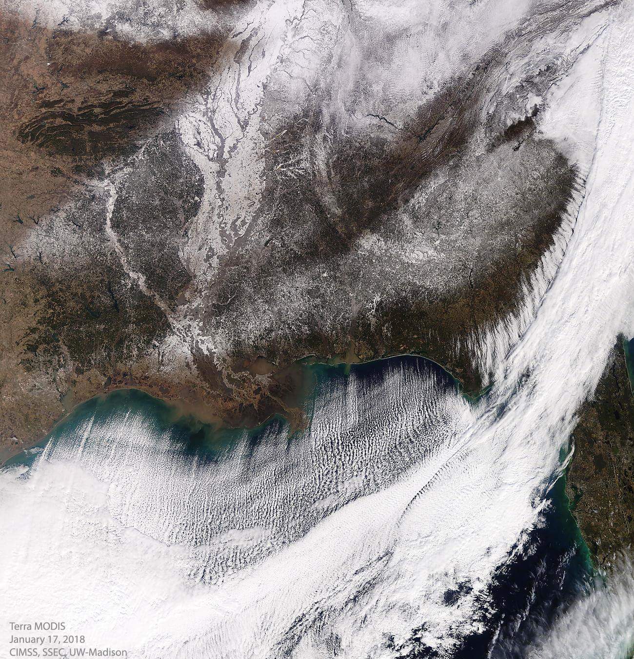
MODIS Satellite Imagery
_____________________________________________________________________________________________________________
Preliminary Snowfall Totals
Location                     Amount

...ARKANSAS...

...Ashley County...
Wilmot                       2.0 in
Crossett                     1.8 in

...Chicot County...
Dermott                      2.3 in
4 NE Dermott                 2.0 in
Lake Village                 2.0 in
Eudora                       1.5 in


...LOUISIANA...

...Catahoula Parish...
Jonesville                   1.0 in
Harrisonburg                 0.5 in

...Concordia Parish...
Vidalia                      0.5 in
Red River Lock               0.1 in

...East Carroll Parish...
Lake Providence              2.0 in
Transylvania                 1.5 in
Lake Providence (COOP)       1.2 in

...Franklin Parish...
8 SW Delhi                   3.1 in
Baskin                       2.0 in
Winnsboro                    2.0 in

...Madison Parish...
Tallulah                     1.5 in

...Morehouse Parish...
2 W Bastrop                  2.2 in
Oak Ridge                    1.0 in

...Richland Parish...
Start                        3.0 in

...Tensas Parish...
St Joseph                    1.5 in

...West Carroll Parish...
Kilbourne                    2.5 in
Oak Grove                    2.5 in
Oak Grove (COOP)             2.0 in


...MISSISSIPPI...

...Adams County...
9 ESE Natchez                1.5 in
Natchez                      0.5 in
4 NE Natchez                 0.5 in

...Attala County...
Kosciusko                    1.0 in
Kosciusko (COOP)             0.8 in
Ethel                        0.8 in
12 SSE Ethel                 0.8 in
6 ESE Kosciusko              0.5 in

...Bolivar County...
Cleveland (Delta State)      2.5 in
Cleveland (COOP)             2.0 in
Shaw                         2.0 in

...Carroll County...
8 ESE Greenwood              0.8 in
5 WNW Vaiden                 0.5 in

...Clay County...
West Point                   0.5 in
4 N West Point               0.4 in

...Choctaw County...
French Camp                  1.8 in
Ackerman                     1.0 in

...Claiborne County...
Port Gibson                  0.5 in

...Clarke County...
Shubuta                      1.5 in
Quitman                      1.3 in
Archusa Creek WP             1.2 in

...Copiah County...
8 WSW Hazlehurst             0.7 in

...Covington County...
Collins                      1.8 in
Seminary                     1.5 in
Dry Creek WP                 0.8 in

...Forrest County...
4 SSW Hattiesburg            1.8 in
Hattiesburg                  1.5 in
Carnes                       1.5 in

...Franklin County...
Bude                         1.2 in
Meadville                    1.0 in

...Grenada County...
Gore Springs                 2.5 in
Holcomb                      2.0 in
Grenada                      1.0 in

...Hinds County...
6 NE Jackson                 1.0 in
Clinton                      0.9 in
2 N Clinton                  0.9 in
6 NW Terry                   0.6 in
NE Jackson                   0.5 in

...Holmes County...
Lexington                    1.5 in

...Humphreys County...
Belzoni                      1.0 in

...Issaquena County...
Mayersville                  2.0 in

...Jasper County...
Heidelberg                   1.8 in
Bay Springs                  1.0 in

...Jefferson County...
Union Church                 1.3 in
Fayette                      0.5 in

...Jefferson Davis County...
Prentiss                     2.0 in

...Jones County...
3 W Laurel                   1.8 in
Eastabuchie                  1.6 in
Laurel                       1.0 in
Ellisville                   0.8 in

...Kemper County...
10 N Collinsville            1.0 in
5 NE Scooba                  0.4 in

...Lamar County...
Oloh                         2.3 in
Sumrall                      2.0 in
Oak Grove                    1.8 in
Purvis                       1.8 in
7 SSE Sumrall                1.8 in
8 WSW Hattiesburg            1.8 in
Sumrall (COOP)               1.3 in

...Lauderdale County...
6 NNW Collinsville           0.8 in
5 SW Collinsville            0.5 in
Meridian                     0.3 in
7 SE Collinsville            0.3 in
4 NNE Collinsville           0.3 in
5 E Collinsville             0.3 in

...Lawrence County...
Monticello                   2.0 in

...Leake County...
Carthage                     1.0 in
Rosebud                      0.7 in
Walnut Grove                 0.5 in

...Leflore County...
7 NNE Schlater               2.5 in
Itta Bena                    2.0 in

...Lincoln County...
Brookhaven                   1.0 in

...Lowndes County...
New Hope                     1.0 in
Columbus AFB                 0.5 in
Columbus                     0.3 in

...Madison County...
7 NW Madison                 1.0 in
Madison                      1.0 in
2 S Flora                    0.9 mi
4 N Canton                   0.6 in

...Marion County...
Columbia                     1.4 in

...Montgomery County...
Winona                       2.0 in
Kilmichael                   0.5 in

...Neshoba County...
Arlington                    0.8 in
Philadelphia                 0.5 in
5 E Philadelphia             0.5 in
4 ENE Union                  0.5 in

...Newton County...
Union                        1.5 in

...Noxubee County...
Brooksville                  0.5 in

...Oktibbeha County...
Mississippi State University 0.5 in
5 S Starkville               0.4 in

...Rankin County...
8 NNE Brandon                1.5 in
4 NW Puckett                 1.2 in
Star                         1.0 in
6 ESE Madison                1.0 in
JAN Airport                  0.8 in
2 W Pearl                    0.8 in
Richland                     0.7 in
3 NNE Brandon                0.6 in
Brandon                      0.5 in

...Scott County...
Forest                       1.0 in

...Simpson County...
5 N New Hebron               1.5 in
5 SSW Puckett                1.0 in
Magee                        0.5 in
Mendenhall                   0.5 in

...Smith County...
3 SW Mize                    0.5 in

...Sunflower County...
Drew                         2.0 in
Inverness                    1.5 in
Moorhead                     1.5 in
Indianola                    0.6 in

...Warren County...
3 ENE Vicksburg              1.5 in
12 S Vicksburg               0.5 in

...Washington County...
Chatham                      2.0 in
Greenville                   1.5 in

...Webster County...
Eupora                       1.5 in
6 SW Eupora                  1.5 in

...Winston County...
Louisville                   1.0 in
Noxapater                    0.8 in
Nanih Waiya                  0.5 in

...Yazoo County...
Benton                       1.8 in
Yazoo City                   1.5 in
Eden                         1.5 in
Tinsley                      1.5 in


Observations are collected from a variety of sources with varying
equipment and exposures. We thank all volunteer weather observers
for their dedication. Not all data listed are considered official.

