
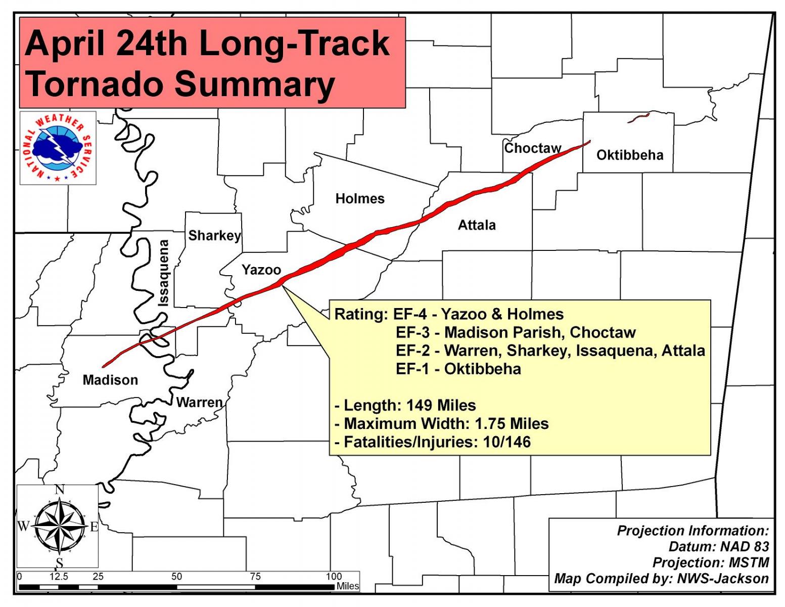
Violent and Deadly Long Track Tornado Plows From Tallulah Louisiana Across Yazoo City to Northeast Mississippi

|
Rating:
(Click for EF Scale) |
EF-4
|
|
Estimated Maximum Wind:
|
170 mph
|
|
Casualties:
|
10 Total Fatalities with Dozens of Injuries
|
|
Damage Path Length:
|
149 miles
|
|
Maximum Path Width:
|
1.75 miles
|
|
Approximate Start Point/Time:
|
5 miles W of Tallulah, LA 32.408N, 91.283W
|
|
Approximate End Point/Time:
|
5.5 miles N of Sturgis, MS 33.430N, 89.054W
|
Preliminary ground surveys along the entire path of the primary supercell thunderstorm that tracked from west of Tallulah, Louisiana to Yazoo City to northeast of West Point on Saturday April 24 have been completed. The conclusion, based on all surveys, is that a single, continuous path of tornadic damage was produced from west of Tallulah, Louisiana to the extreme western part of Oktibbeha County in northeast Mississippi. The tornado appeared to dissipate at this point but the storm produced two additional tornadoes in the NWS Jackson service area: an EF-1 in northern Oktibbeha County and an EF-2 in northeast Clay County.
The main long track tornado was strong almost from its initial stage of development in northeast Louisiana. EF-2 and EF-3 damage was common all along the tornado’s path into central Mississippi with areas of EF-4 damage observed in both Yazoo and Holmes counties. After crossing Interstate 55, the tornado weakened with EF-1 and occasional EF-2 damage being commom as the tornado moved across Attala County. The tornado reintensified as it moved into Choctaw County, with at least high end EF-3 damage occurring northwest of the Weir community. The tornado remained strong before rapidly weakening and then dissipating just after moving into Oktibbeha County.
Path Summary
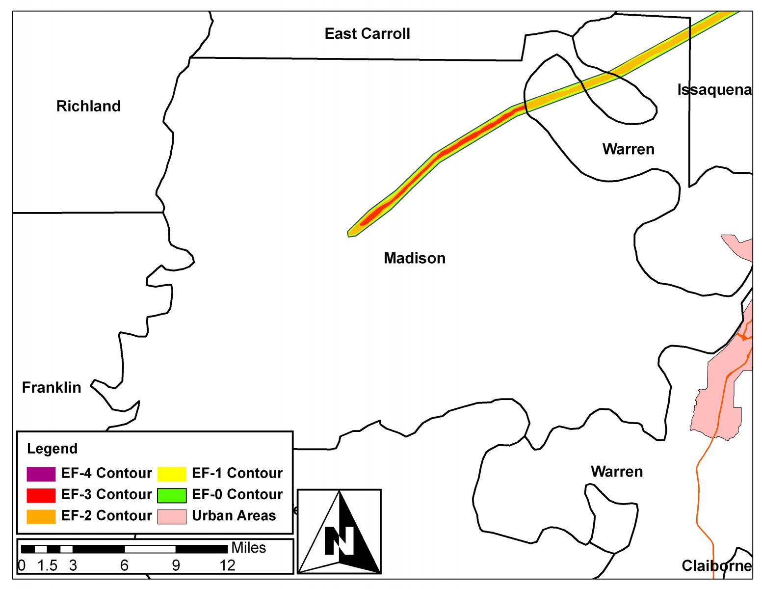
The tornado became strong almost immediately, bending and destroying several high tension power poles west of Tallulah. The tornado then crossed Interstate 20, blowing an 18 wheeler off the road. As the tornado passed northwest and north of Tallulah, it heavily damaged or destroyed a number of homes. Before crossing the Mississippi River, it caused near total destruction of a chemical plant near the Omega community. It crossed the Mississippi River, and damaged or destroyed numerous homes on the north side of Eagle Lake. The tornado then moved across the Delta National Forest in Issaquena and Sharkey Counties, causing major tree damage. The tornado again caused significant home damage northwest of Satartia, and again as it crossed Highway 3 near the Crupp community. The tornado then moved through rural area southwest of Yazoo City, causing major damage or destruction of a number of homes, as well as intense tree damage. As the tornado approached the intersection of US Highway 49 and Highway 16 on the south side of Yazoo City, it reached its widest point and maximum intensity. Several buildings, including a church and several businesses, were totally destroyed. The tornado continued moving through residential areas on the southeast side of Yazoo City, heavily damaging or destroying numerous homes. The tornado continued northeast through rural eastern Yazoo and southern Holmes counties, causing intense tree damage and damaging or destroying a number of rural residences. As the tornado moved by the Franklin community in rural Holmes county, it again reached EF-4 intensity as it completely destroyed two brick homes and heavily damaged or destroyed a number of other homes. The tornado then crossed Interstate 55, causing significant tree damage and blowing a number of vehicles off the road. As the tornado approached the area just south of Durant and crossed US Highway 51, it narrowed and reached one of its weakest points. However, shortly thereafter it reintensified somewhat and began causing significant tree damage in rural western Attala County. The tornado continued across northern Attala County, causing tree damage and heavily damaging a number of rural residences, including in the community of Hesterville. The tornado intensified further as it crossed the Natchez Trace Parkway, and approached EF-4 intensity as it passed northwest of Weir. Numerous homes were heavily damaged or destroyed in this area. The tornado maintained strong intensity as it crossed the remainder of Choctaw County, including damaging a number of homes as it cross state Highways 415, 9 and 15. The tornado rapidly narrowed and weakened as it crossed into Oktibbeha county, and dissipated north of the town of Sturgis.
Track Maps
  |
  |
   |
  |

