Jackson, Mississippi
Weather Forecast Office
The spring of 2007 seems to have started a bit early with the region seeing its first severe weather outbreak. A large and powerful storm system took shape as a deep surface low tracked across Kansas and into portions of Iowa on Feb 24th. This strong area of low pressure was driven by a powerful upper level trough which supported very strong winds through the entire atmosphere. These winds were felt at the surface to some degree as a large area across the Lower Mississippi River Valley saw sustained winds between 25-35 mph with gusts between 40-50 mph. Below are some measured winds across the service area which occured in advance of the severe weather:
|
Station
|
ID
|
Sustained wind (mph)
|
Peak wind (mph)
|
| Jackon International Airport | JAN |
31
|
43
|
| Key Field - Meridian Airport | MEI |
31
|
40
|
| Vicksburg - Tallulah Regional Airport | TVR |
38
|
44
|
| Greenville Airport | GLH |
38
|
47
|
| Greenwood - Leflore Airport | GWO |
41
|
52
|
| Hattiesburg Chain Municipal | HBG |
28
|
35
|
| Natchez - Adams County Airport | HEZ |
31
|
43
|
| Hawkins Field - Jackson | HKS |
36
|
45
|
Those gradient winds, in advance of the severe weather, were strong enough to down some trees and power lines across the region. Those damage reports were more scattered in nature.
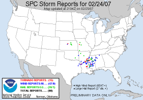
Those strong winds from the deepening surface low helped to draw northward moisture and instability. The strong winds allowed for the environment to become highly sheared. Basically, there were increasing winds with height and a change in the wind direction as well. This particular combination of instability and high shear was quite rare. However, this set the stage for a severe weather outbreak which included damaging winds, large hail and tornadoes. Below is a regional view of the severe weather reports from Feb 24th.
Select links below to view details about specific storms. Each location will contain damage photos from area storm surveys and radar images matching the event.
Catahoula - Concordia Tornado (EF-2)
Rankin County Tornado (EF-1)
Newton County Tornado (EF-1)
Sunflower County Tornado (EF-1)
US Dept of Commerce
National Oceanic and Atmospheric Administration
National Weather Service
Jackson, Mississippi
234 Weather Service Dr.
Flowood, MS 39232
601-936-2189
Comments? Questions? Please Contact Us.
Thank you for visiting a National Oceanic and Atmospheric Administration (NOAA) website. The link you have selected will take you to a non-U.S. Government website for additional information.
NOAA is not responsible for the content of any linked website not operated by NOAA. This link is provided solely for your information and convenience, and does not imply any endorsement by NOAA or the U.S. Department of Commerce of the linked website or any information, products, or services contained therein.
You will be redirected to:


