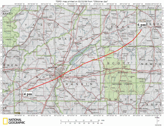
The tornado initially developed near the old Adams community, several miles south southwest of Raymond in Hinds County, at about 4 pm on March 3rd. It moved east northeast, moving across the rural areas along Dry Grove Road, Midway Road and Springridge Road. Along with heavily damaging homes and farms, the tornado also destroyed at least one large radio/TV antenna tower structure in this area. The tornado then moved into the Jackson city limits, destroying the Candlestick Park shopping center and a number of homes and businesses in this same area, which is along Cooper Road near Cany Creek. Pictures from the Candlestick Park area show businesses and homes leveled to the ground, and eyewitnesses reported cars thrown more than a half of a mile and pavement scoured off of the ground. All of this is indicative of violent (F4 or F5) tornado damage. After moving through this area, the tornado passed across the Pearl River into Rankin County. Nineteen people were killed in Hinds County, most at Candlestick Park or nearby.
|
|
Once in Rankin County, the tornado mainly passed through what was then a very rural area. The tornado did cause very heavy damage to an industrial area near Flowood, in the Flowood Drive area. How the tornado evolved from here is unclear. Media depictions and official reports indicate a track similar to the one shown above. However, eyewitness accounts our office has recently received from people who lived in Rankin County at the time of the Candlestick Park tornado, indicate damage north of this track in Rankin County. This includes areas north of the current route of Highway 25, including areas near Fannin and Sand Hill. This would mean that the Candlestick Park “tornado” might actually be two tornadoes produced by the same supercell thunderstorm in a cyclic manner, as shown in the graphic below.
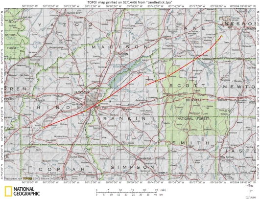 |
In any event, whether caused by the same tornado or a new tornado which formed in east central Rankin County, much of the most intense damage in Rankin County occurred in the areas south and southwest of the Leesburg community in northeastern Rankin County. Six people were killed in these areas. The tornado then moved into Scott County, where some of the worst devastation appears to have taken place. The destruction was particularly catastrophic in the area north of Branch and near Forkville in northwest Scott county. Pictures and video from this area show houses destroyed to the foundation, large swaths of trees totally annihilated, and chicken houses obliterated. Eyewitnesses again reported road pavement scoured out by the force of the tornado. The tornado continued east-northeast, with additional heavy damage near the Midway community in north-central Scott county. Before moving out of Scott County, the tornado would kill 26 people in this county alone.
After causing the destruction in Scott County, the tornado moved into Leake County, crossing the county line along Highway 35 south of Walnut Grove. The tornado moved closer to due northeast through southeastern Leake County. Six people were killed in the area between the Madden and Salem communities as more than 40 homes and buildings were totally destroyed. Significant tornado damage continued into southwest Neshoba County, where nearly a dozen homes were heavily damaged or destroyed, and the historic Carolina church, which was more than 100 years old, was completely leveled to the ground. One person was killed near the Dowdville community.
Reports indicate that the tornado weakened and may not have had a continuous path after this point, although official records do indicate a single track through the remainder of Neshoba County, and into Kemper and Noxubee counties. The tornado did produce an additional path of F2 damage in Pickens and Tuscaloosa counties in Alabama, and one person was killed in Pickens County. The official track for the tornado shows a continuous, 202.5 mile track from Hinds County, Mississippi to Tuscaloosa County, Alabama. The tornado dissipated about 745 pm near Tuscaloosa.
If the Tornado Happened Today
While the information currently available makes it impossible to plot the tornado’s path with precise certainty, it seems clear that if this same tornado happened today, damage would have been much greater. As was mentioned above, the tornado moved through what was in 1966 a rural area of Rankin County. While the exact path down to the tenths of a mile is not certain, it seems very clear that the tornado moved near what is now Highway 25 (Lakeland Drive). Homes and businesses in the area around River Oaks, the north side of Jackson International Airport, Laurel Wood, and Castlewoods, lie in or near where the tornado moved through. Additionally, the area around Candlestick Park in south Jackson is more heavily populated today than it was 40 years ago.
Furthermore, the time of day during which this tornado occurred would be particularly dangerous. The tornado was moving through the Jackson metropolitan area between 430 pm and 5 pm, during the afternoon rush hour time period. In 1966, the interstate system was in the process of being constructed, but today the tornado would have been moving near the “Stack” area just south of downtown Jackson where Interstates 20 and 55 converge. The tornado would have also been passing near the heavily trafficked areas along Highway 80, Flowood Drive, and Lakeland Drive in Flowood. Numerous casualties may very well have occurred to people in vehicles in all of these areas.
Clearly, a violent tornado moving along this same path would be even more catastrophic today than it was in 1966. While advanced meteorological technology and science, as well as improved communications, would hopefully yield more precise warning information to the public today, the increase in population and infrastructure along the path might result in as many, or even more, casualties today than in 1966.