Jackson, Mississippi
Weather Forecast Office
The first sounding is a view of the atmospheric conditions at 12z (6am) across Central MS. Of note, you can see that the warm front was located south of Jackson at this time shown by the "cool" inverted temperatures profile in the lowest few thousand feet. The sounding shows high moisture below 850mb with a large amount of dry air above that. This dry layer is also providing steep lapse rates over the region with a decent "cap" in place. These steep lapse rates, combined with the high low-level moisture, provided substantial instability (~1554 j/kg of MUcape) above the frontal boundary. As the warm front lifts north, the warm surface temperatures will result in this instability becoming rooted at the surface and will set the stage for a "potentially" active day. Click on thumbnails for a larger image.
 |
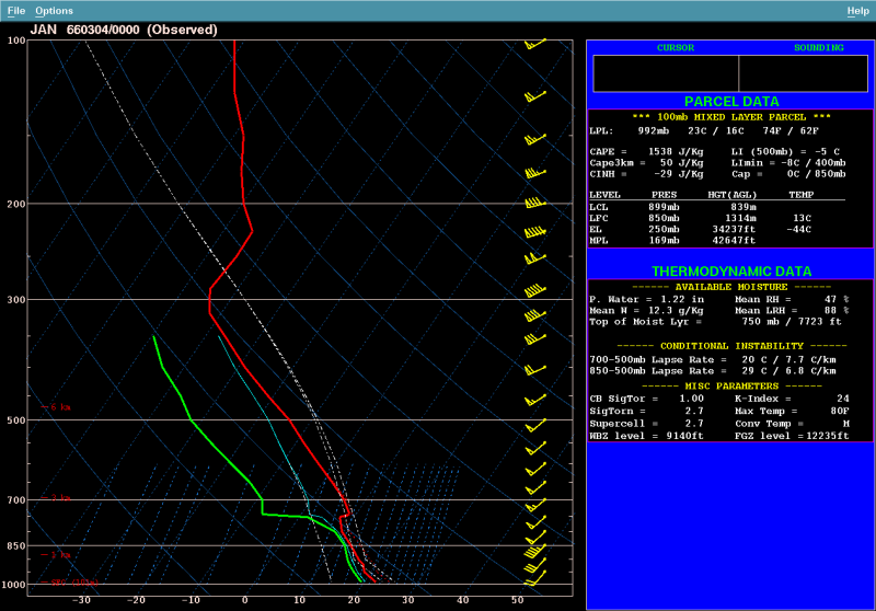
The next sounding was observed at 00z (6pm), shortly after the tornado moved through the Jackson Metro and while it was still on the ground. This sounding was slightly modified to represent the surface conditions just before the tornado occurred. As you can see, moisture has increased in the low-levels and gotten deeper. The "cap" is still in place, but weaker, and is likely contributing to the limited amount of storms and supporting "explosive" type development. The lapse rates remain quite steep and continue to support high levels of instability (~1538 j/kg of MLcape or ~2300 j/kg of SBcape). The wind fields are quite strong resulting is high levels of shear. This 00z depiction of the winds is likely not representative due to the fact that this data was obtained after the storm passed. The winds shown below are unidirectional (from the same direction) which actually verifies the previously talked about wind shift feature or trough passage. Just ahead of the storm, winds were likely more from the south in the first 1-2 thousand feet and then more SW, similar to what is shown on the below sounding.
 |
US Dept of Commerce
National Oceanic and Atmospheric Administration
National Weather Service
Jackson, Mississippi
234 Weather Service Dr.
Flowood, MS 39232
601-936-2189
Comments? Questions? Please Contact Us.

