November 2001 Storm of the Month
A pair of Supercell Thunderstorms, both producing F4 Tornadoes, occurred on Saturday the 24th. One storm tracked for 32 miles across the Delta region in Washington and Bolivar counties. From a radar imagery standpoint...our Storm of the Month for November occurred only 14 miles northwest of the radar. This storm became very impressive as a Tornadic Vortex Signature Mesocyclone was detected for a time early that morning over southern Madison County which also happened to be the holiday Thanksgiving weekend. This storm became the first F4 Tornado to strike within 40nm of the 88D Radar since installation back in early 1993.
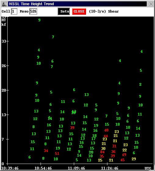
This Classic Supercell formed ahead of a weakening squall line before sunrise. The storm had peak VILs of 62 kg/m*m before 5 am while a tilted strong Mesocyclone Core can be seen about 20 minutes later in the Reflectivity Cross Section which appeared to also have a double BWER structure. The Mesocyclone peaked at a Rank 8 with a MSI of 8445 at 523 am as you can see from the Mesocyclone Table. The corresponding MSI trend table shows the cycling up of the rotation with the missing plots on the time trend of 7790 at 517 am and the 8445 at 523 am. The MSI of 8445 is, by far, the highest ever recorded by the KJAN 88D and is a value rarely seen anywhere in the nation.
Hail the size of baseballs in northern Hinds county preceded the development of the F4 Tornado that struck the Fairfield subdivision in west Madison killing 2 people and injuring nearly 2 dozen. At least 47 houses were destroyed.
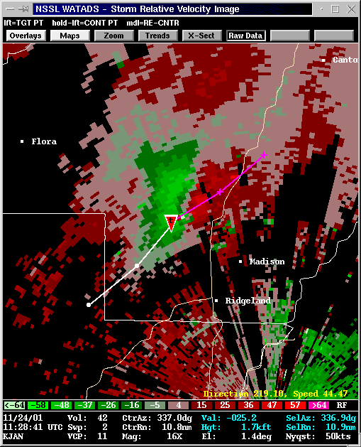
Storm Relative Velocity View with TVS track at 528 am cst shortly after tornado touchdown.
 |
A Base Reflectivity View with Storm Cell Track at 517 am cst(note developing hook echo feature).
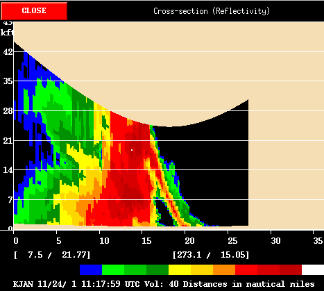 |
Vertical Cross Section View with double BWER at 517 am cst.
 |
 |
Maximum Shear Trend Table at 548 am cst.
 |
Maximum Gate-to-Gate Trend Table at 548 am cst
 |
Mesocyclone Table Analysis at time of peak Shear(523 am cst).
 |
Cell Table Analysis at time of peak VIL(458 am cst).
 |
MSI(Mesocyclone Strength Index) Time trend(missing plots of 7790 at 517 am and the 8445 at 523 am).

