
Excessive rainfall may produce locally considerable flash flooding over parts of the northwestern Gulf Coast, lower Mississippi River Valley, and Deep South through Thursday. Potential Tropical Cyclone One is forecast to become a tropical storm (Arthur) as it moves along or just off the northwestern Gulf coast through Wednesday. An outbreak of severe weather is forecast in the Midwest Wednesday. Read More >
Hawaiʻi > Hawaiʻi Tsunami Evacuation Zone Maps
 |
 |
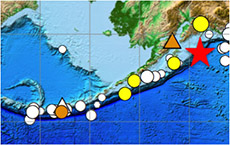
In 2010, Hawaiʻi scientists began investigating plausible worst-case tsunami inundation modeling scenarios along the Aleutian Trench. A gigantic tsunami generated in this source region would provide the least evacuation time, approximately 4-5 hours, for Hawaiʻi residents, making it the most dangerous far-field tsunami to prepare for.
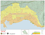
Scientists found that O‘ahu, tsunami inundation from a M9.2 earthquake in the eastern Aleutians would far exceed the flooding observed in Hawaiʻi from past historical tsunamis. Independent geological evidence on Kaua‘i and in Alaska also suggested that such a tsunami was generated sometime in the past 500 years. In response to these findings, the City & County of Honolulu, in conjunction with State, Federal, and community stakeholders, developed an additional 2nd evacuation tier (Tier 2) for the Extreme Tsunami scenario, which represents a worst case, extreme, once in a thousand years tsunami event for the State of Hawaiʻi. The Tier 2 Extreme maps represent an unlikely worst-case scenario and do not replace the current, Tier 1 standard tsunami evacuation maps, which are based on historical tsunamis. These same studies were conducted for Hawaiʻi, Maui, and Kaua'i Counties, and 2-tier evacuation maps were found necessary and updated for Mau and Kaua'i County.
Click to view Oahu online 2-tier Tsunami Evacuation maps
Click to view Maui County online 2-tier Tsunami Evacuation maps
Click to view and download Kauai County 2-tier Tsunami Evacuation maps
Click to view and download Hawaiʻi County Tsunami Evacuation Maps
View and download Tsunami Safety Rules flyers, click here.
View and download Hawaiʻi Boater's Hurricane and Tsunami Safety Manual, click here.
View and download ITIC's collection of Hawaiʻi maps and posters, click here.

