>
|
Large Wildfires Burn Across Portions of West Texas April 2011 |
|||||||
 |
|||||||
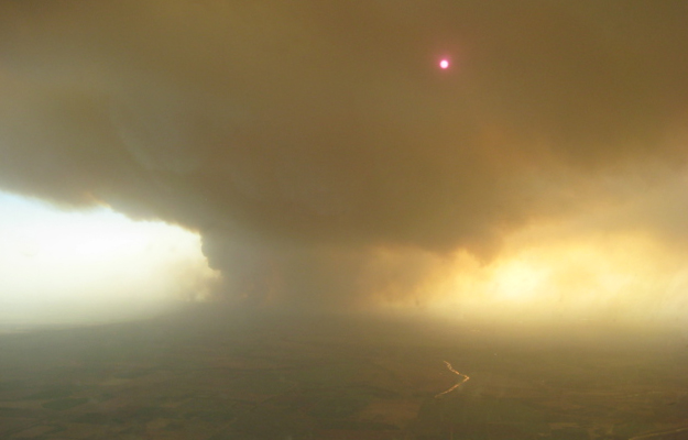
| Picture of the Swenson fire in Stonewall County taken on April 7, 2011. Photo is courtesy of the Texas Forest Service. | |||||||
|
The combination of weather, near record amounts of cured fuels and an escalating drought have made conditions favorable for significant wildfires across West Texas this winter and spring. On several occasions through this late winter and spring stretch, the fire danger has been pushed to extreme levels as passing storm systems have generated very windy, warm and dry weather. These conditions have been proven to be particularly conducive to support significant grassland wildfires. One particularly bad fire weather day occurred on February 27. More recently, April has seen a prolonged stretch of warm (to hot), dry and breezy to windy weather, further exacerbating the wildfire risk. On April 6th, a wildfire was started near Swenson, northwest of Aspermont in Stonewall County, likely from an accidental ignition by a cutting torch being used on pipe. The weather conditions were favorable to quickly grow and spread this fire, with the fire engulfing large portions of Stonewall County, and spreading into the Kent and Knox Counties as it was driven to the north and east on strong winds. This fire has become known as the Swenson fire. |
|||||||
 |
|||||||
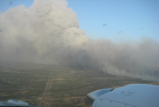
| Another picture of the Swenson fire in Stonewall County taken on April 7, 2011. Photo is courtesy of the Texas Forest Service. | |||||||
| The Swenson fire continued to burn through the weekend (April 9-10) as winds and dry weather stoked it. The fire has been reported to have consumed more than 100,000 acres of land, while also damaging or destroying several unoccupied structures (including two old ranch houses) and numerous utility poles. An unknown number of livestock have also been lost to the fire. | |||||||
 |
 |
||||||
| Two more picture of the Swenson fire in Stonewall County taken on April 7, 2011. Click on the images for a bigger view. Photos are courtesy of the Texas Forest Service. | |||||||
|
The significant fires early this April weren't limited to the Swenson area. Another significant fire started north of Post on Saturday, April 9th, on a particularly hot and windy day. This fire destroyed at least one home and for a time threatened the town of White River Lake late Sunday afternoon. A third fire also burned around 15,000 acres in Terry County on the 9th. Five homes were threatened by this fire, but the responding emergency personnel were able to save the homes and eventually contain the fire. In addition, numerous other large wildfires started and caused considerable damage across the West Texas region on Saturday. One fire burned from near Marfa through the town of Fort Davis and destroyed 30 or more homes. Another fire affected portions of Midland, and damaged and destroyed tens of homes. Other fires burned near Alpine and Fort Stockton as well as near Clayton, New Mexico, and in southwest Oklahoma, near Granite. The image below shows the burn scars caused by the fires in West Texas.
The extreme fire danger was further exacerbated by another passing storm system Thursday and Friday, April 14-15, 2011. This storm system brought widespread severe weather from central Oklahoma eastward through the southeastern United States. However, the western half of Texas saw an increase in winds and continued very dry air, which stoked ongoing fires and supported new ignitions. The westerly winds pushed a fire toward the town of Rotan Thursday evening, though thankfully, the town was saved. A strong cold front pushed then moved through Thursday night, bringing a northerly wind shift and cooler air to the region. Unfortunately, though, northerly winds quickly increased on Friday, with gusts in excess of 60 mph recorded over parts of the Panhandles into the Rolling Plains as the upper level storm system wrapped up over the central plains. Severe winds with gusts of 58 mph or more spread across the eastern Texas Panhandle through much of the Rolling Plains. The highest wind speed reported was a 67 mph gust at the Childress Airport. The two maps below show the maximum wind gusts reported across the region by stations of the Texas Tech West Texas Mesonet and the storm reports issued by the National Weather Service from the 15th. You can also view the local storm report summary from the Lubbock office HERE. |
|||||||
 |
|||||||
| Map displaying the maximum wind gusts (mph) recorded across the South Plains region on Friday, 15 April 2011. The observations are courtesy of the West Texas Mesonet and the National Weather Service. Click on the above map for a larger view. | |||||||
|
|||||||
|
|
|||||||
| MODIS Satellite imagery of West Texas on the afternoon of Friday, April 15, 2011. Many burn scars and smoke plumes can be seen. Additionally, a large dust plume is noted from the eastern Texas Panhandle into western North Texas, where northwesterly winds gusted over 50 and 60 mph. Click on the image to view a larger version. Image is courtesy of the NASA/GSFC, MODIS Rapid Response. | |||||||
|
The strong winds fanned ongoing fires and again led to new starts on the 15th. One smoke plume was directed right across San Angelo, where some places saw visibilities drop below 1/4 mile in smoke and falling ash. The above satellite image displays burn scars and smoke plumes across West Texas Friday afternoon. Although the magnitude of fire danger will vary from day to day through the remainder of this spring, the threat of significant wildfires will continue until West Texas experiences a good green-up and rains begin to fall. Click here to view a West Texas Mesonet summary on the April 15, 2011, winds and wildfires. |
|||||||
|
|
|||||||
| MODIS Satellite imagery of West Texas on the afternoon of Saturday, April 16, 2011. Many burn scars and smoke plumes can be seen. Additionally, we have annotated the latest information on the latest active wildfires in the area. Click on the image to view a larger version. Image is courtesy of the NASA/GSFC, MODIS Rapid Response. | |||||||


