|
Another Round of Cold Temperatures and Low Wind Chills |
||
|
|
||
| Visible satellite image captured on Tuesday afternoon (February 8, 2011). Most of the white on the map represents low clouds, through areas of snow can be seen on the edge of the Caprock to the north-northeast of Lubbock. The clouds were found behind a strong Arctic cold front. Click on the image for a larger view. | ||
|
The second week of February, similar to the first week of the month, brought a surge of Arctic air to the South Plains region. The very cold air initially built into the Panhandles early Tuesday (February 8th), and was reinforced by widespread low clouds. The low clouds and cold air dipped into the northwest South Plains early Tuesday afternoon, but the clouds generally stayed north and west of Lubbock through much of the day (see the above satellite image). At one point during the middle of the afternoon, temperatures ranged from the lower to middle 60s ahead of the cold front across the southern Rolling Plains to single digits over the southwest Texas Panhandle, behind the front. |
||
|
|
||
| Wind chill observations around 10:30 pm on Tuesday evening (February 8, 2011). The data are courtesy of the West Texas Mesonet and the NWS. Click on the map for a larger view. | ||
|
Late Tuesday afternoon and Tuesday evening the cold front plunged southward, with northerly winds sustained between 30 and 40 mph quickly transporting the cold air southward across the entire area. The strong winds, coupled with temperatures falling into the single digits across the entire area, resulted in bitterly cold wind chills between 10 and 30 degrees below zero. Above is a snapshot of the low wind chill readings observed late Tuesday evening. Looking closer at the temperatures, Lubbock reached its high of 46 degrees shortly after noon before the temperature began plunging through the afternoon and evening hours. By 8 pm the temperature at Lubbock stood at only 9 degrees, with north winds around 30 mph. The temperature drop was even more dramatic east of Lubbock. For instance, the West Texas Mesonet site near Aspermont dropped from 56 degrees at 6:15 pm, to 46 degrees at 6:20 pm and down to 39 degrees in another 5 minutes. Shortly after 8:30 pm Aspermont was in the teens. To read a statement written about the cold temperatures and low wind chill Tuesday night and Wednesday morning CLICK HERE. |
||
|
|
||
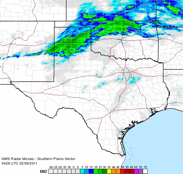
| Radar loop ending at 11:38 pm on Tuesday evening (February 8, 2011). A large band of snow can be seen extending from northern Oklahoma into east-central New Mexico. To view a radar loop that ends at 7:48 pm CLICK HERE. | ||
|
In addition to the frigid temperatures and strong winds, an upper level storm system moved across the region and brought snow to the Panhandles and northern sections of the South Plains and Rolling Plains. The heaviest band of snow setup across Amarillo (see the above radar loop) and brought blizzard conditions and around a half a foot of snow. Further south, a period of moderate to heavy snow clipped across the southern Texas Panhandle, with widespread 2-3 inch totals reported. However, Happy did report of a total of 5 inches. Further south snow totals were much lighter, with only a dusting observed in Lubbock. To view a statement summarizing the snow that fell over parts of the area during the cold overnight hours CLICK HERE. |
||
 |
 |
|
| Images captured of snow falling in Muleshoe (left) and Plainview (right) on Tuesday night (February 8, 2011). The pictures are courtesy of KAMC. Click on the respective image for a larger view. | ||
| The below image shows what the snowpack looked like from space after the storm system had moved east of the area on Wednesday. A deep layer of snow was put down from north of Clovis through Amarillo and Canadian, with a sharp cutoff in the accumulating snow noted into the central South Plains and Rolling Plains. The largest snow total reported to the NWS Amarillo office was 12 inches at Canadian, with numerous 6-12 inch totals. | ||
|
|
||
| Visible satellite image captured on Wednesday afternoon (February 9, 2011). The white on the map is areas of snow. Click on the image for a larger view. | ||


