National Weather Service United States Department of Commerce

Elevated southerly winds will continue into this evening. Sustained speeds between 20 and 30 mph can be expected with gusts up to 35 mph.
Persistent elevated southerly winds will lead to water piling up along the coast and into coastal waterways, with minor coastal flooding expected during times of high tide through Thursday. Water levels are expected to reach between 1.5 and 2.0 feet mean higher high water, which could lead to flooding of roads, parks and lots.
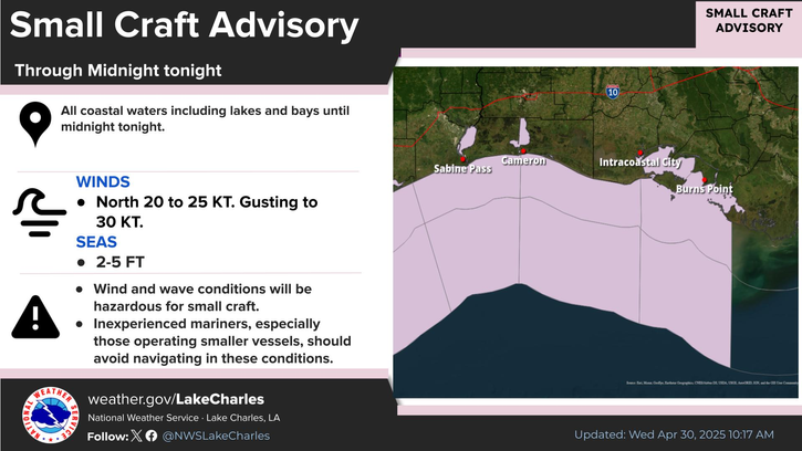
Elevated southerly winds and building seas will result in rough and hazardous weather conditions for small craft, and a Small Craft Advisory is in effect through at least 1 AM Friday.
A storm system consisting of a cold front and robust upper level trough will bring an Enhanced Risk for severe storms to portions of central Louisiana on Saturday; the remainder of the area will see a Slight Risk. The best chance for severe storms looks to be Saturday afternoon into Saturday night although timing may change as this system draws closer.
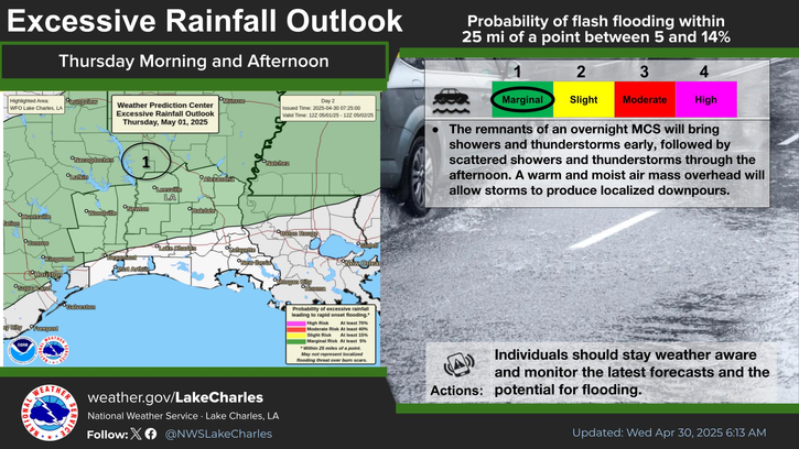
A storm system crossing the area Saturday will bring widespread showers and thunderstorms. Convection will be capable of producing heavy rain leading to flash flooding. A Slight Risk (level 2 out of 4) or up to a 39 percent chance for Excessive Rainfall that may lead to flash flooding across central Louisiana, and a majority of Southeast Texas, as well as southwest and south central Louisiana. Turn Around Don't Drown!!
Very warm and humid conditions are expected through Friday, along with very gusty southerly winds. A slow-moving front will sag through the region this weekend, bringing our next chance for rain and thunderstorms. Cooler temperatures will return in the wake of the front by the end of the weekend into early next week.

Latest Text Product Selector
 
 
Hourly Weather Roundup ( )
Location Sky/Weather Temp Dewpt RH Wind Baro Remarks
Lake Charles
N/A
N/A
N/A
N/A
N/A
N/A
N/A
Abbeville
N/A
N/A
N/A
N/A
N/A
N/A
N/A
Alexandria
N/A
N/A
N/A
N/A
N/A
N/A
N/A
Beaumont
N/A
N/A
N/A
N/A
N/A
N/A
N/A
De Quincy
N/A
N/A
N/A
N/A
N/A
N/A
N/A
De Ridder
N/A
N/A
N/A
N/A
N/A
N/A
N/A
Fort Johnson
N/A
N/A
N/A
N/A
N/A
N/A
N/A
Jasper
N/A
N/A
N/A
N/A
N/A
N/A
N/A
Jennings
N/A
N/A
N/A
N/A
N/A
N/A
N/A
Lafayette
N/A
N/A
N/A
N/A
N/A
N/A
N/A
Nederland/Port Arthur
N/A
N/A
N/A
N/A
N/A
N/A
N/A
New Iberia
N/A
N/A
N/A
N/A
N/A
N/A
N/A
Oakdale
N/A
N/A
N/A
N/A
N/A
N/A
N/A
Opelousas
N/A
N/A
N/A
N/A
N/A
N/A
N/A
Orange
N/A
N/A
N/A
N/A
N/A
N/A
N/A
Patterson
N/A
N/A
N/A
N/A
N/A
N/A
N/A
Pineville
N/A
N/A
N/A
N/A
N/A
N/A
N/A
Sulphur/Carlyss
N/A
N/A
N/A
N/A
N/A
N/A
N/A
"N/A" or "MISG" will be displayed if values are not available. In the LOCATION column, click on links for a list of recent observations at sites of interest. In the WIND column, VRB is "variable" and G is "gust". Wind speeds are in MPH. In the BARO (pressure) column, values are in inches. In the REMARKS column, HX is "heat index", WCI is "wind chill index", and VSB is "visibility" (if shown).
 

Current Weather
 
Rivers & Lakes
 
Forecast Maps
 
Hour By Hour Forecast
 
Tropical Weather
 
Marine Forecast
 
Text Bulletins
 
Forecast Discussion
 
NOAA Weather Radio
 
Submit Storm Report