
March 8-14, 2026 is Severe Weather Preparedness Week in Indiana.
Governor Mike Braun has proclaimed March 8-14, 2026 to be Severe Weather Preparedness Week in the state of Indiana.
The National Weather Service, in conjunction with the Indiana State Police, the Indiana Department of Homeland Security, the Indiana Department of Education, the Indiana Broadcasters Association, the American Red Cross, and Amateur Radio Operators will conduct a statewide test of communication systems on Tuesday, March 10 at 10:15 AM EDT/9:15 AM CDT.
Important Notes - while the drill will be sent using live TOR EAS coding (Tornado Warning), it is only a test, and will be postponed to Wednesday, March 11 if weather conditions warrant. The test warning will activate the Emergency Alert System (EAS) and include SAME activation on NOAA Weather Radio, but will NOT trigger a Wireless Emergency Alert (WEA). (NWS Wilmington, OH will send the test for their Indiana counties using the RWT coding, per an agreement with their Cincinnati broadcast market partners)
Help the NWS and partners protect your community: become a trained storm spotter!
As part of NWS efforts to build a Weather Ready Nation, the goal of Severe Weather Preparedness Week is to better educate people about the hazards of severe thunderstorms and tornadoes, and to help everyone be prepared when severe weather occurs.
Each day will focus on a different topic. NWS Indianapolis will make approximately 5-6 posts via social media throughout each day of Severe Weather Preparedness Week. Visit us on Facebook and X (@NWSIndianapolis) for information on the following themes:
For information on National Weather Service Impact-Based Warnings (IBW) and what their content indicates, click here.
Click here for a kids' activity booklet from the Indiana Department of Homeland Security.
Severe weather safety information in Spanish can be found here. Aquí encontrará información en español sobre seguridad en caso de inclemencias meteorológicas.
Know the difference between a watch and a warning, and the definitions of Severe Thunderstorm Warnings, Tornado Warnings, and Flash Flood Warnings!


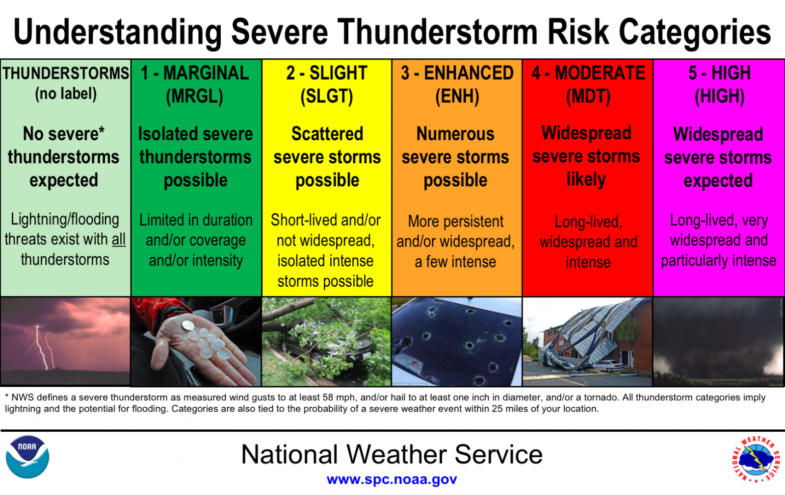
Know what Storm Prediction Center Severe Weather Outlook Categories mean!
Also, new for 2026 - Conditional Intensity Outlooks are added to the SPC Convective Outlooks - a video explainer can be found here.
What should you do at each step as severe weather threatens - outlook (hours to days in advance), watch (minutes to hours in advance), warning (event is threatening now)? Think READY (outlook), SET (watch), GO (warning)! Click on the images below for specific steps to take.


Click here to learn more about Wireless Emergency Alerts, an important way that NWS provides location-based alerts to your smartphone for Tornado Warnings, Flash Flood Warnings, and more.
Flood Threats Often Overlooked
This week, we also remind Hoosiers to be aware of the underappreciated but deadly dangers of flooding. On average, flooding is the deadliest thunderstorm-related hazard. Indiana suffered 2 known flood fatalities in 2025. Elsewhere across the country, numerous lives were sadly lost to flooding. The majority of flood deaths are completely preventable and occur as a result of people driving into flood waters. Click the "Turn Around, Don't Drown!" barriers below to learn more. Click the flood safety image to see a Turn Around, Don't Drown PSA on YouTube.


Our partners at the American Red Cross have released an "emergency app" for smartphone and tablet users. It provides location-based severe weather alerts from the National Weather Service, as well as the ability to quickly send an "I'm Safe" message to the Red Cross in case loved ones are unable to contact you. Additionally, the application provides access to lifesaving tips on actions to take, shelter locations, and more. Click here to see it and other Red Cross safety applications designed to help you prepare for and respond to life-threatening weather emergencies and other hazards.
Our partners at the Federal Emergency Management Agency have also produced an app that is your personalized disaster resource for all stages of disaster response - plan, protect, and recover. Find this app and more information here.
As part of NWS efforts to build a Weather Ready Nation with our partners and the public, severe weather preparedness efforts have also gone national in recent years. Click the image below to learn more about what YOU can do to "Be a Force of Nature."


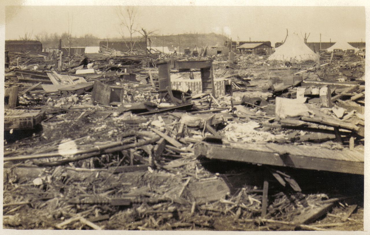
(The ruins of Griffin, IN after the Tri-State Tornado of March 18, 1925 - the deadliest tornado in American history)

