 |
| Other Event Reviews: Eastern Missouri/Southwest Illinois (NWS St. Louis) Central Illinois (NWS Lincoln) |
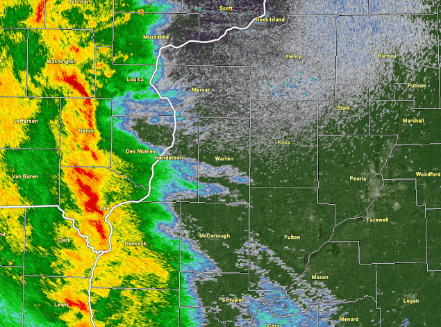
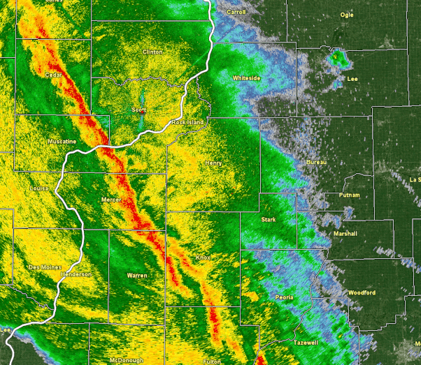
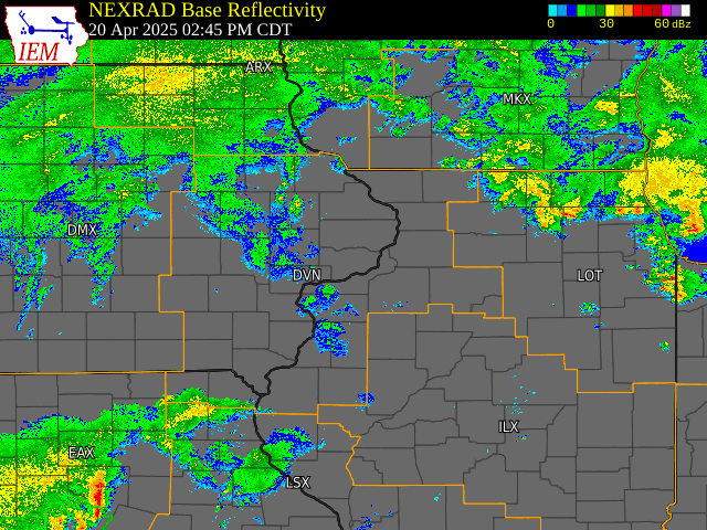
Radar
| West Central Illinois Radar Loop: 7 P.M. - 8:15 P.M. CDT | Northwest Illinois Radar Loop: 8:15 P.M. - 9:55 P.M. CDT | |
 |
 |
|
| IEM - Event Radar Loop |
 |
Storm Reports
| SPC Severe Weather Event Review for Sunday April 20, 2025 |
 |
 |
Preliminary Local Storm Report...Summary
National Weather Service Quad Cities IA IL
727 PM CDT Wed Apr 23 2025
..TIME... ...EVENT... ...CITY LOCATION... ...LAT.LON...
..DATE... ....MAG.... ..COUNTY LOCATION..ST.. ...SOURCE....
..REMARKS..
0710 PM Tstm Wnd Dmg 1 SSE Beaverdale 40.83N 91.21W
04/20/2025 Des Moines IA NWS Storm Survey
Snapped power poles and a storage facility
destroyed. Peak winds 80 to 90 MPH.
0713 PM Tstm Wnd Dmg 1 N Bowen 40.24N 91.06W
04/20/2025 Hancock IL Emergency Mngr
Updates previous LSR. One outbuilding
heavily damaged and one destroyed. Time of
the event estimated using radar.
0714 PM Tstm Wnd Gst 1 SE Beaverdale 40.84N 91.21W
04/20/2025 M60 MPH Des Moines IA Trained Spotter
Estimated wind speeds of 55 to 60 MPH.
0717 PM Tstm Wnd Gst Burlington Regional Air 40.79N 91.13W
04/20/2025 M61 MPH Des Moines IA Public
Measured a 53 knot gust. Also occurred at
714 PM CDT.
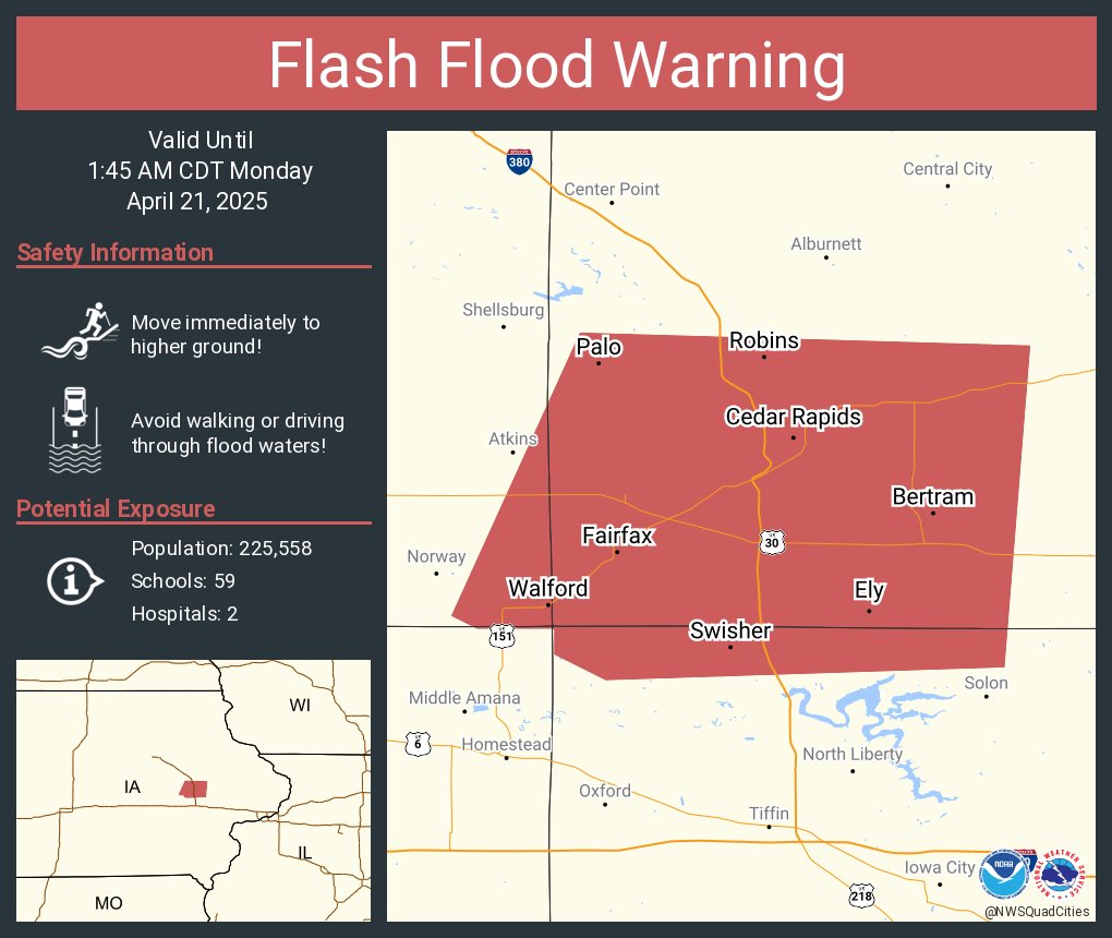
0731 PM Flash Flood 3 W Cedar Rapids 41.97N 91.73W
04/20/2025 Linn IA Public
Report from mPING: Street/road flooding;
Street/road closed; Vehicles stranded.
0736 PM Tstm Wnd Dmg 4 E Fandon 40.38N 90.70W
04/20/2025 McDonough IL Public
70 MPH measured wind gust and small branches
1 inch in diameter broken. Time estimated by
radar.
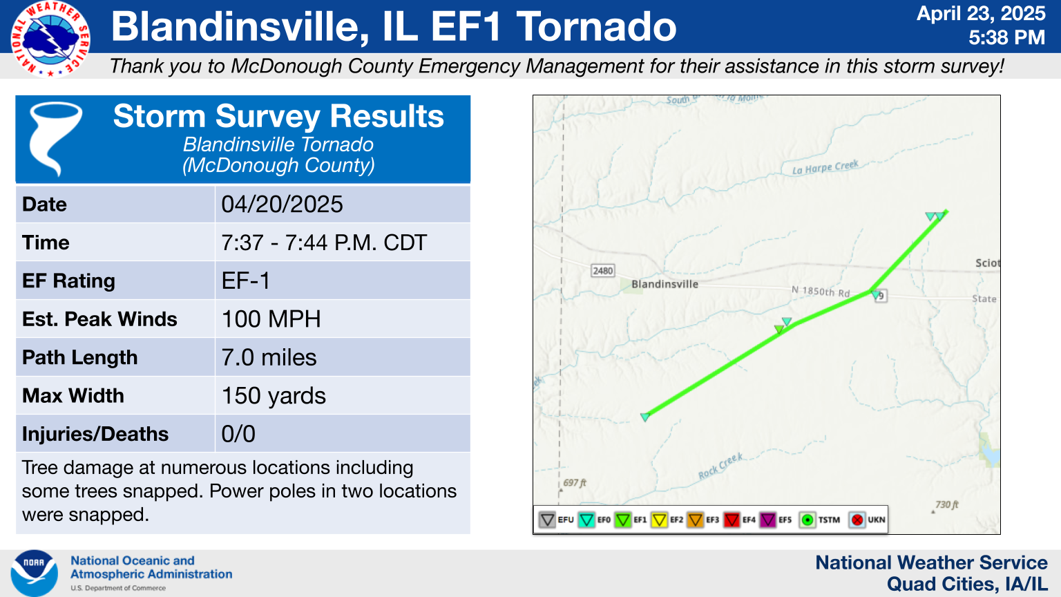
0737 PM Tornado 2 S Blandinsville 40.52N 90.88W
04/20/2025 McDonough IL NWS Storm Survey
An EF1 tornado started just south of
Blandinsville and tracked to NE along a 7
mile path. Tree damage was noted at numerous
locations with large branches and some trees
snapped. Power poles in two locations were
snapped, resulting in an estimated max wind
speed of 100 MPH.
0745 PM Tstm Wnd Dmg Macomb 40.47N 90.68W
04/20/2025 McDonough IL Emergency Mngr
Apartment roof heavily damaged. In
coordination with Emergency Management and
reviewing photos of the damage and areas
around it, this was determined to be from
straight-line winds. Time estimated using
radar.
0745 PM Tornado 2 N New Boston 41.20N 91.00W
04/20/2025 Mercer IL NWS Storm Survey
EF0...Peak Winds 85 MPH...Path Length 0.8
miles...Path Width 25 yards.
0746 PM Tstm Wnd Dmg 1 N Macomb 40.47N 90.68W
04/20/2025 McDonough IL Trained Spotter
Large tree blown down over roof of house
with siding damage.
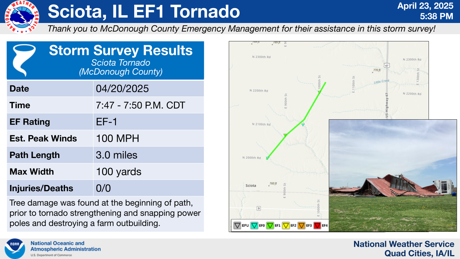
0747 PM Tornado 1 NNE Sciota 40.57N 90.74W
04/20/2025 McDonough IL NWS Storm Survey
An EF1 tornado occurred just to the NE of
Sciota. Tree damage was found at the
beginning of the 3 mile track. The tornado
then strengthened and snapped power poles
and eventually destroyed a farm outbuilding,
with an max estimated speed of 100 MPH.
0750 PM Tstm Wnd Dmg 3 SE Macomb 40.44N 90.65W
04/20/2025 McDonough IL Trained Spotter
Several shingles lost from roof of house.
Time estimated by radar.
0752 PM Flash Flood 2 SSE Hiawatha 42.02N 91.67W
04/20/2025 Linn IA Trained Spotter
Report of creek flowing out of its banks
along Center Point Road and I-380. Photos
were also submitted showing the flooded
creek. Total rainfall of 2 to 3 inches was
reported around Cedar Rapids.
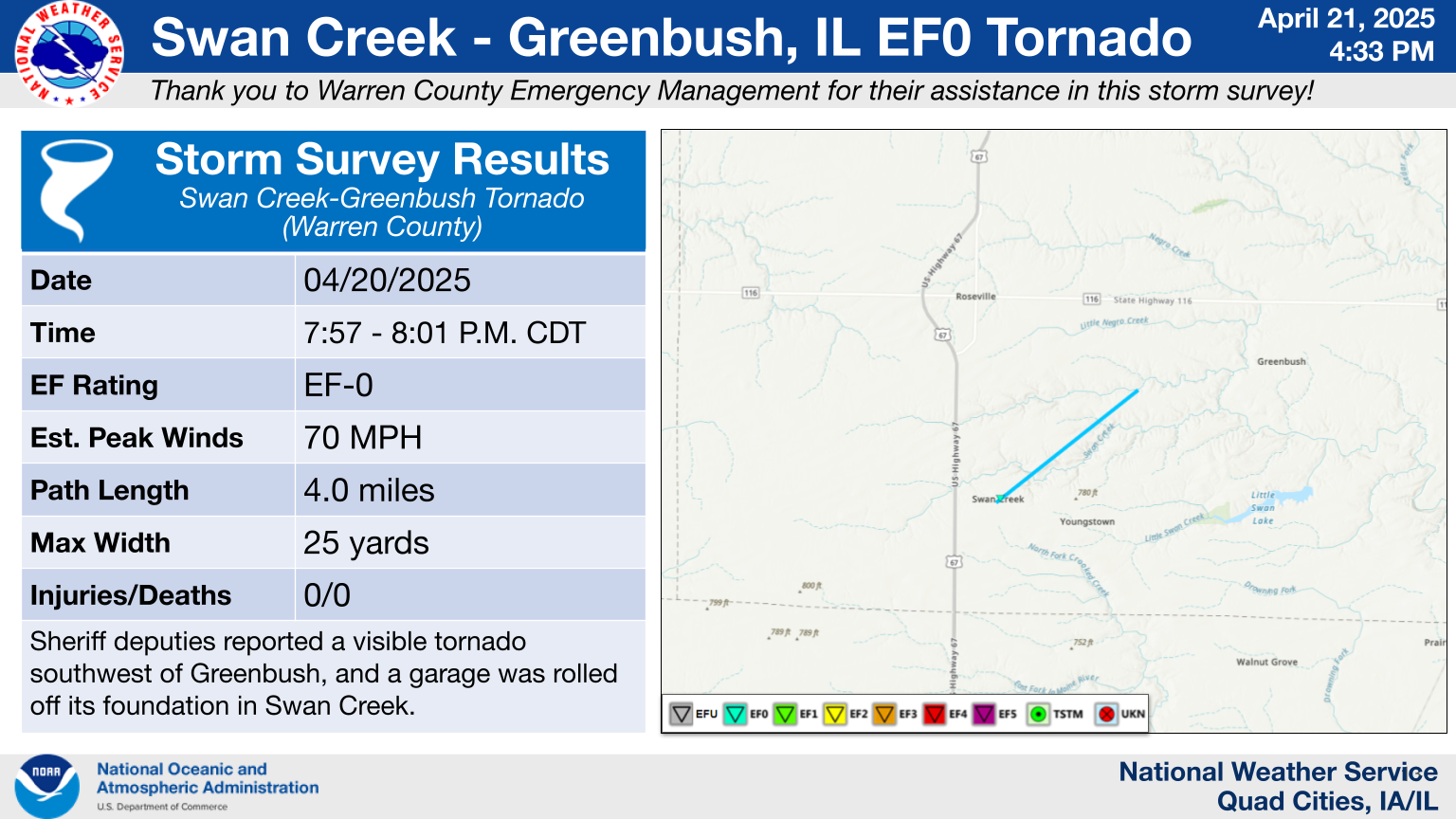
0757 PM Tornado Swan Creek 40.67N 90.65W
04/20/2025 Warren IL NWS Storm Survey
Multiple deputies reported seeing a tornado
from near Greenbush looking back southwest.
Linking that with the garage damage by Swan
Creek would make for a short-lived tornado
which lines up with radar. No other damage
reported by Warren County EMA Director. EF0
with 70 MPH max winds.
0800 PM Rain 3 W Cedar Rapids 41.97N 91.73W
04/20/2025 M2.40 Inch Linn IA Trained Spotter
0812 PM Rain 1 WSW Mt Hamill 40.74N 91.64W
04/20/2025 M1.55 Inch Lee IA Trained Spotter
Storm total rainfall.
0816 PM Flash Flood 1 NW Marion 42.05N 91.60W
04/20/2025 Linn IA Public
Report from mPING: Street/road flooding;
Street/road closed; Vehicles stranded.
0827 PM Flash Flood 2 S Hiawatha 42.02N 91.69W
04/20/2025 Linn IA Public
Report from mPING: Street/road flooding;
Street/road closed; Vehicles stranded.
0830 PM Tstm Wnd Dmg 1 N Credit Island 41.52N 90.61W
04/20/2025 Scott IA 911 Call Center
911 dispatch relayed a report of a tree that
fell on a parked vehicle. Time estimated by
radar.
0834 PM Tstm Wnd Dmg 2 NW Sherrard 41.34N 90.54W
04/20/2025 Rock Island IL NWS Storm Survey
Barn partially damaged and some branches
down. Isolated to this one property. Time
estimated using radar.
0836 PM Tstm Wnd Dmg 2 N New Windsor 41.24N 90.44W
04/20/2025 Henry IL Trained Spotter
Spotter has an anemometer reading of 65 MPH
with a 4 inch tree limb down.
0841 PM Flash Flood 2 W Marion 42.02N 91.62W
04/20/2025 Linn IA Public
Report from mPING: Street/road flooding;
Street/road closed; Vehicles stranded.
0845 PM Rain Cantril 40.64N 92.07W
04/20/2025 M1.89 Inch Van Buren IA Trained Spotter
0847 PM Rain 3 ENE Charlie Heath Mem 40.59N 91.84W
04/20/2025 M2.10 Inch Clark MO Trained Spotter
Rainfall total.
0850 PM Tstm Wnd Dmg Galva 41.16N 90.03W
04/20/2025 Henry IL Emergency Mngr
Pine tree top blown off. Time estimated from
radar data.
0854 PM Tstm Wnd Dmg 1 SSW Le Claire 41.59N 90.37W
04/20/2025 Scott IA NWS Storm Survey
Corrects previous tstm wnd dmg report from 1
SSW Le Claire. Tree uprooted at this
location.
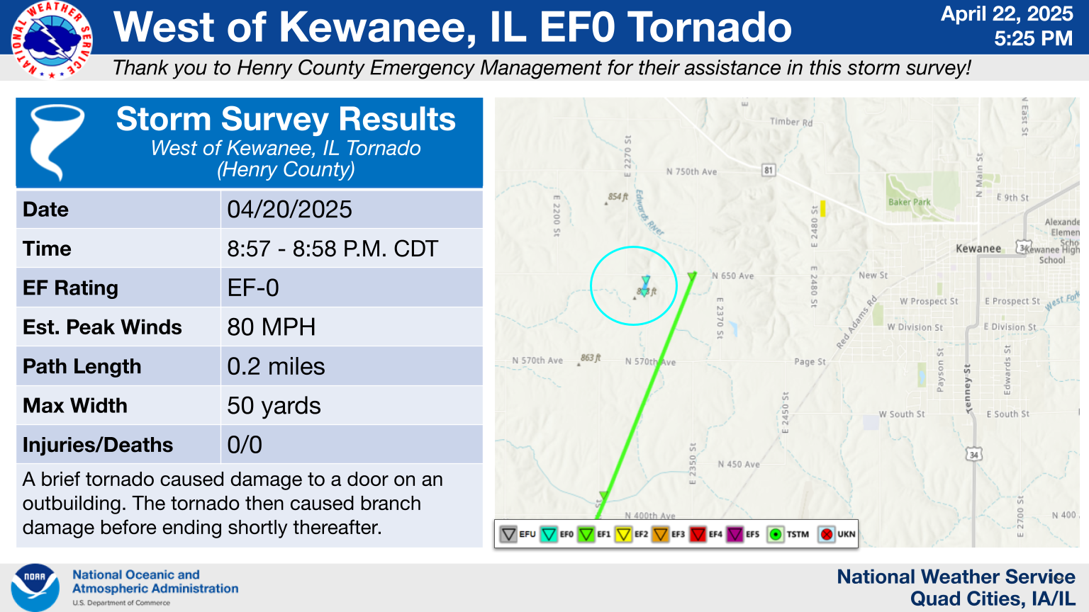
0857 PM Tornado 4 W Kewanee 41.24N 89.99W
04/20/2025 Henry IL NWS Storm Survey
Brief tornado caused damage to a door on an
outbuilding. The tornado then caused branch
damage before ending shortly. EF0 with 80
MPH max winds.
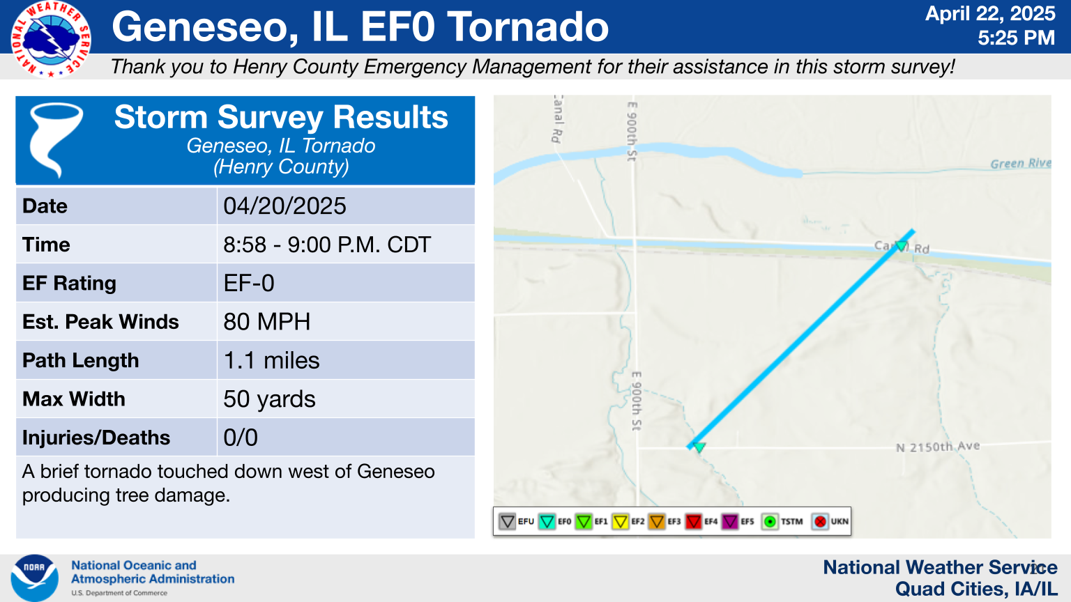
0858 PM Tornado 4 SSE Osborn 41.46N 90.24W
04/20/2025 Henry IL NWS Storm Survey
A brief tornado caused damage to trees. EF0
with 80 MPH max winds.
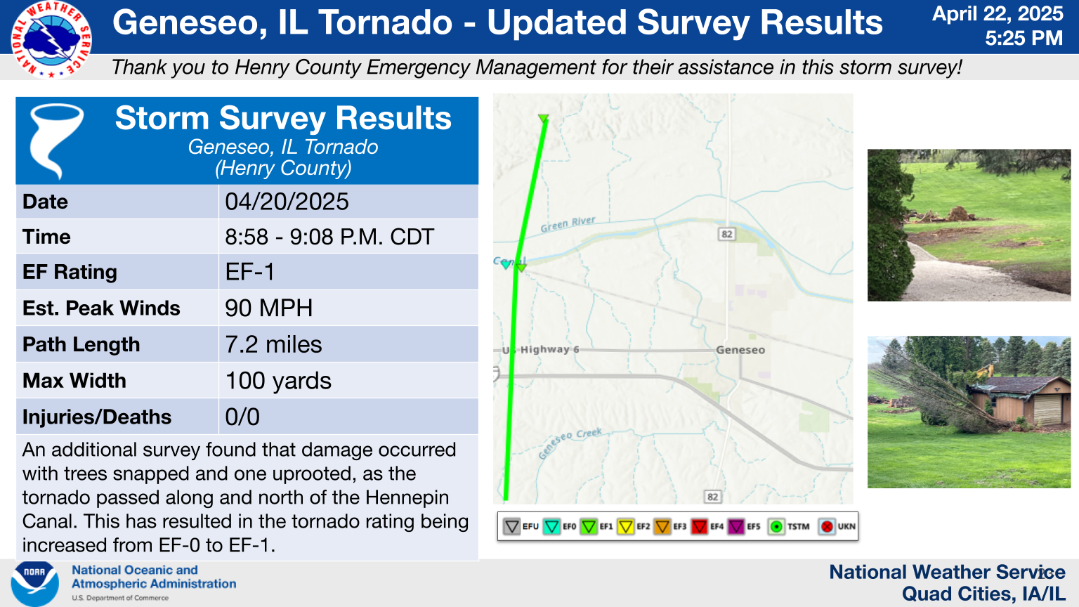
0858 PM Tornado 4 E Morristown 41.41N 90.23W
04/20/2025 Henry IL NWS Storm Survey
A tornadic debris signature was seen on the
KDVN Doppler Radar up to 2,900 ft. Corn
stubble and leaves were found along the
beginning of the path. As the tornado
approached the Hennepin Canal, tree damage
was found with snapped hardwood trees and
other branches. Additional branches were
found just southwest of Shady Beach.
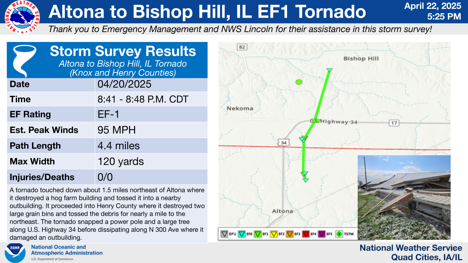
0858 PM Tornado 1 SSW German Corner 41.29N 90.04W
04/20/2025 Henry IL NWS Storm Survey
An EF1 tornado formed to the NE of Kewanee
and tracked to the north and ended just
south of Atkinson. Trees along the 7 mile
path were snapped at the trunk. Some
branches were downed as well. At the end of
the path a structure was destroyed by max
winds estimated to be 95 MPH.
0907 PM Rain 1 NE Marion 42.04N 91.58W
04/20/2025 M2.32 Inch Linn IA Trained Spotter
Total rainfall since 9 AM this morning.
0909 PM Tstm Wnd Dmg 4 SSE Osborn 41.47N 90.23W
04/20/2025 Henry IL Trained Spotter
Trees down over train tracks. Probable
tornado damage.
0912 PM Tstm Wnd Dmg 3 SSE Milo 41.16N 89.56W
04/20/2025 Bureau IL Trained Spotter
6 inch diameter tree branches down. Time
estimated from radar data.
0915 PM Tstm Wnd Dmg Cordova 41.68N 90.31W
04/20/2025 Rock Island IL Public
Multiple trees downed at cemetery. Time
estimated using radar.
0916 PM Rain Belle Plaine 41.90N 92.28W
04/20/2025 M1.50 Inch Benton IA Trained Spotter
0916 PM Rain Shellsburg 42.09N 91.87W
04/20/2025 M1.50 Inch Benton IA Public
Storm total rainfall.
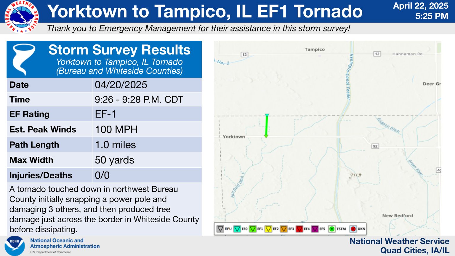
0926 PM Tornado 2 E Yorktown 41.57N 89.81W
04/20/2025 Bureau IL NWS Storm Survey
Corrects previous tornado report from 2 E
Yorktown. One power pole was snapped at the
beginning of the path. Three other power
poles were replaced as well. This tornado
then tracked north and led to tree damage
just across county border into Whiteside
County. EF1 tornado with max winds of 100
MPH.
1011 PM Rain 2 NW Marion 42.06N 91.61W
04/20/2025 M2.17 Inch Linn IA Trained Spotter
1015 PM Rain 2 NW Cedar Rapids 41.99N 91.70W
04/20/2025 M2.70 Inch Linn IA Trained Spotter
1035 PM Rain 5 W South Gorin 40.38N 92.11W
04/20/2025 M1.95 Inch Scotland MO Trained Spotter
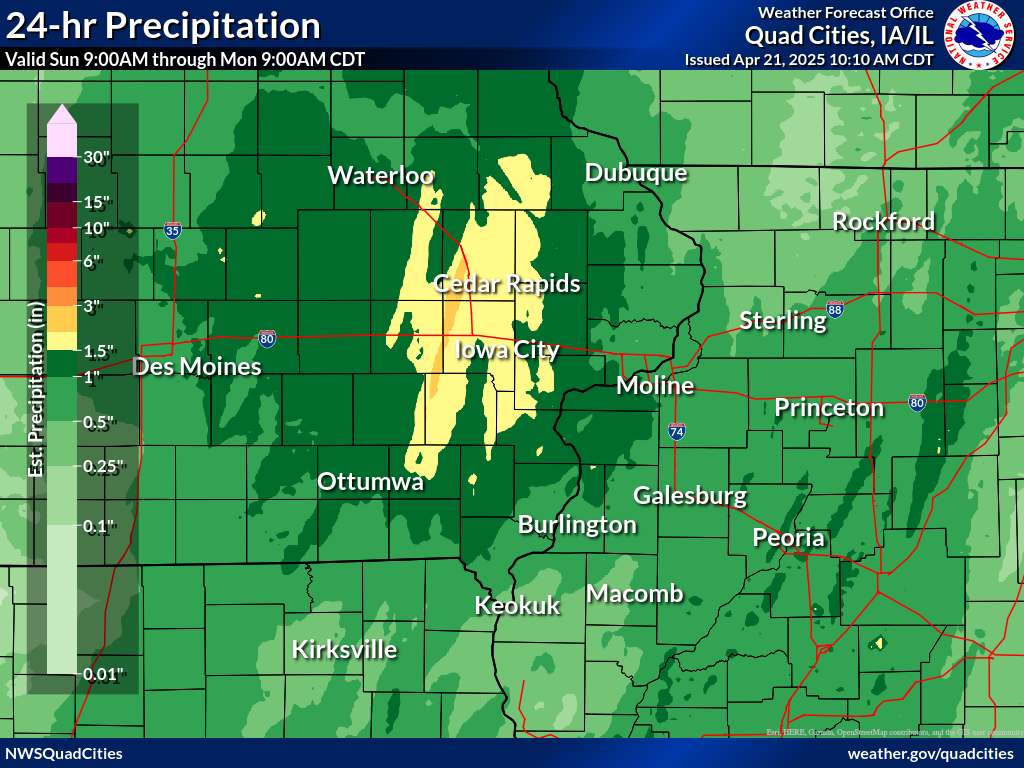
Rain Reports
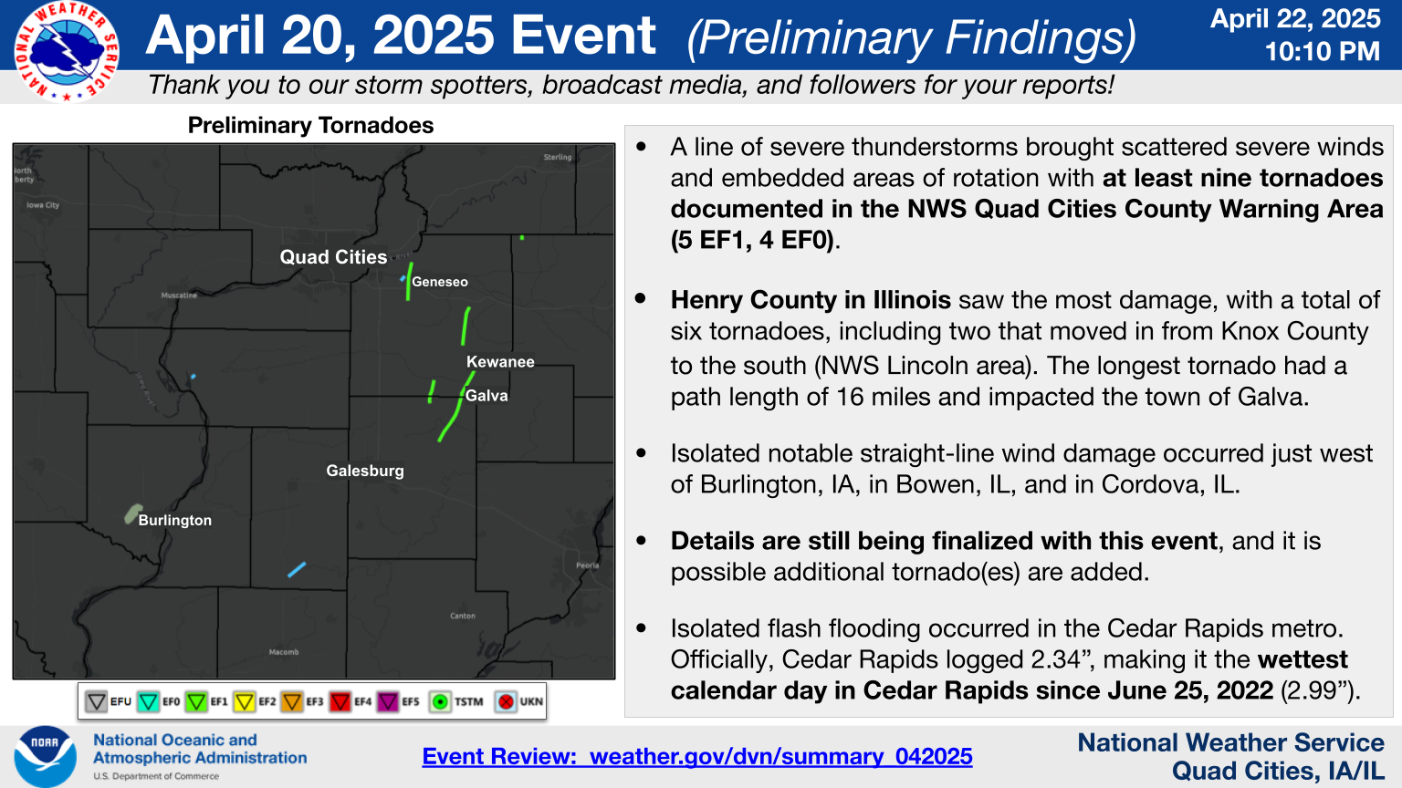
Isolated flash flooding occurred in the Cedar Rapids metro. Officially, Cedar Rapids logged 2.34" of rain, making it the wettest calendar day in Cedar Rapids in nearly three years (2.99" on June 25, 2022).
 |
 |
|||
24 hour precipitation reports (in Inches),
for eastern Iowa, northwest and west central Illinois,
and northeast Missouri. Reported between Midnight and 9 AM,
Monday April 21, 2025.
|
||||
|
||||
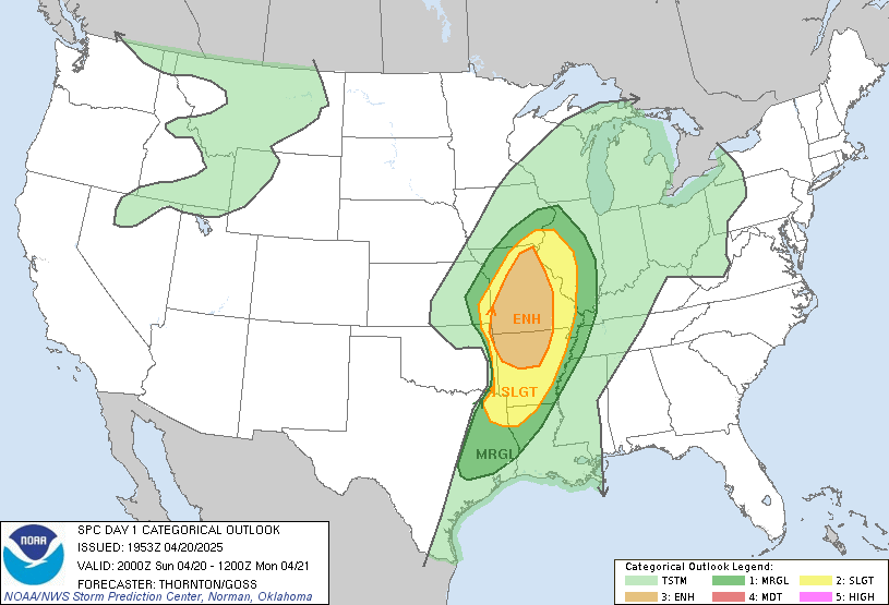
Environment
Storm Prediction Center Outlooks
 |
 |
 |
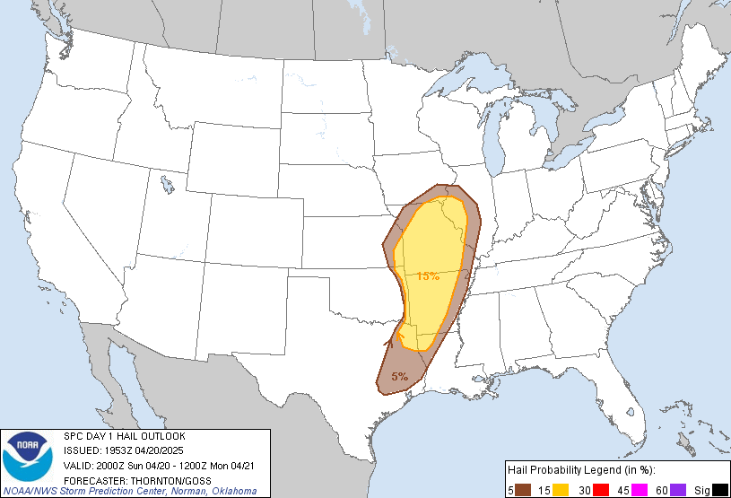 |
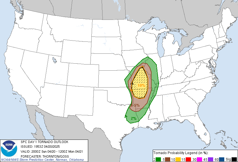
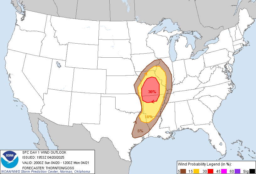
| SPC Day 1 2000z Outlook | Tornado Risk Probabilities | Severe Wind Risk Probabilities | Severe Hail Risk Probabilities |
Watches and Mesoscale Discussions
 |
 |
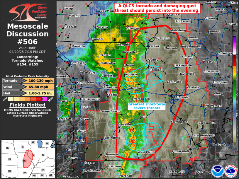 |
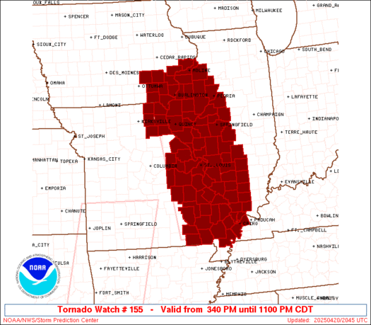
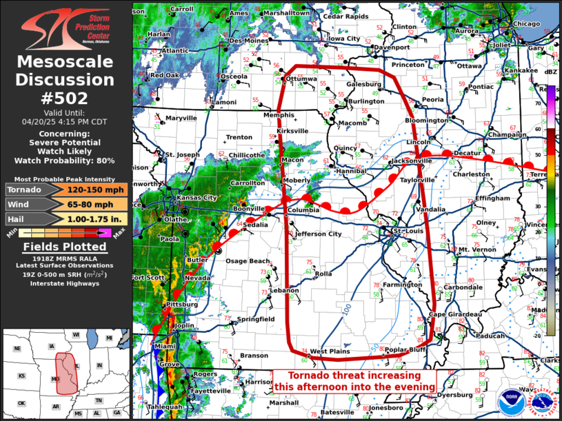
| Tornado Watch #155 | Mesoscale Discussion #502 | Mesoscale Discussion #506 |
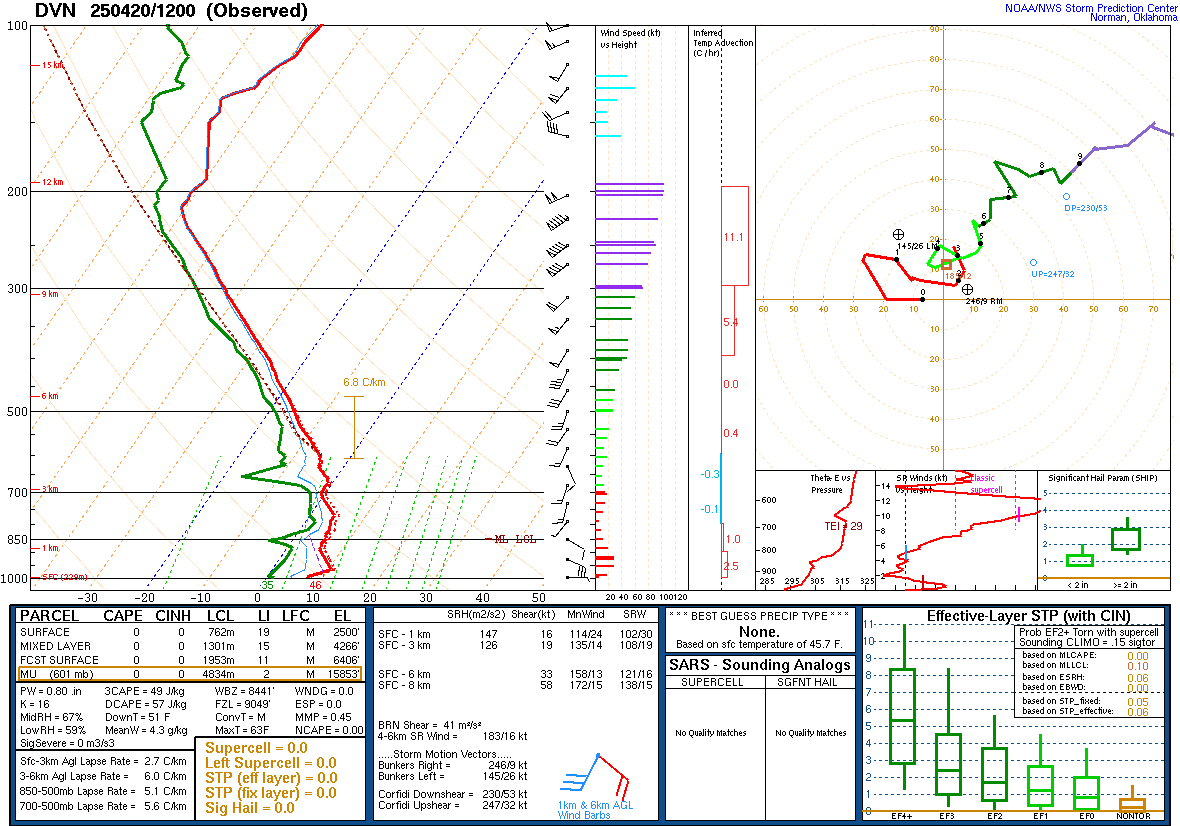
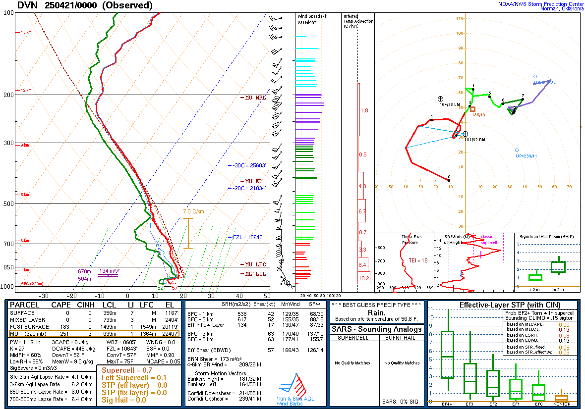
Davenport, IA Soundings
 |
 |
|
| 04/20/2025 - 7:00 am | 04/20/2025 - 7:00 pm |
Synoptic Environment
 |
 |
 |
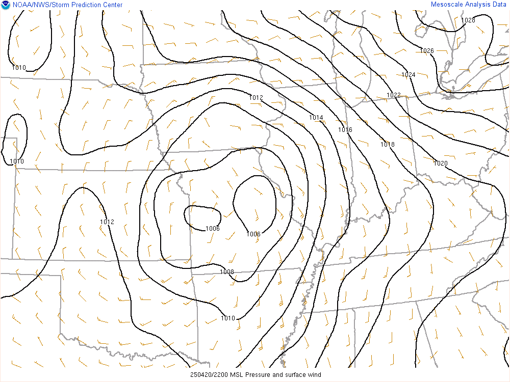 |
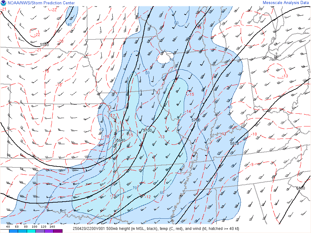
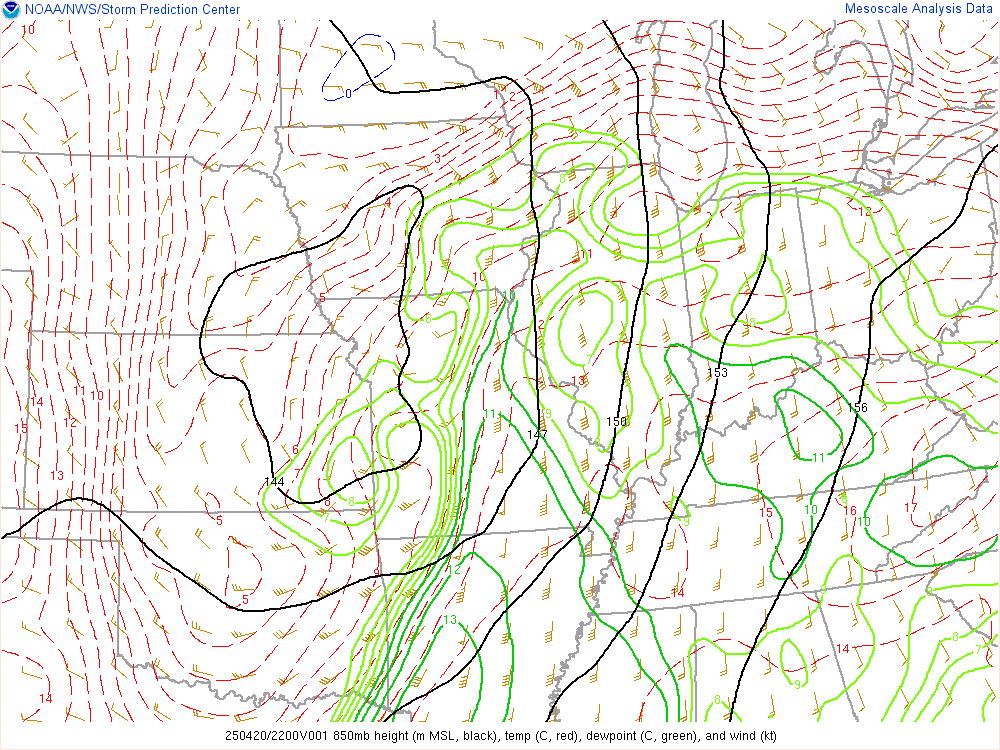
| 500 mb Chart at 5pm | 700 mb Chart at 5pm | 850 mb Chart at 5pm | Surface Chart at 5pm |
Mesoscale Environment
 |
 |
 |
 |
|
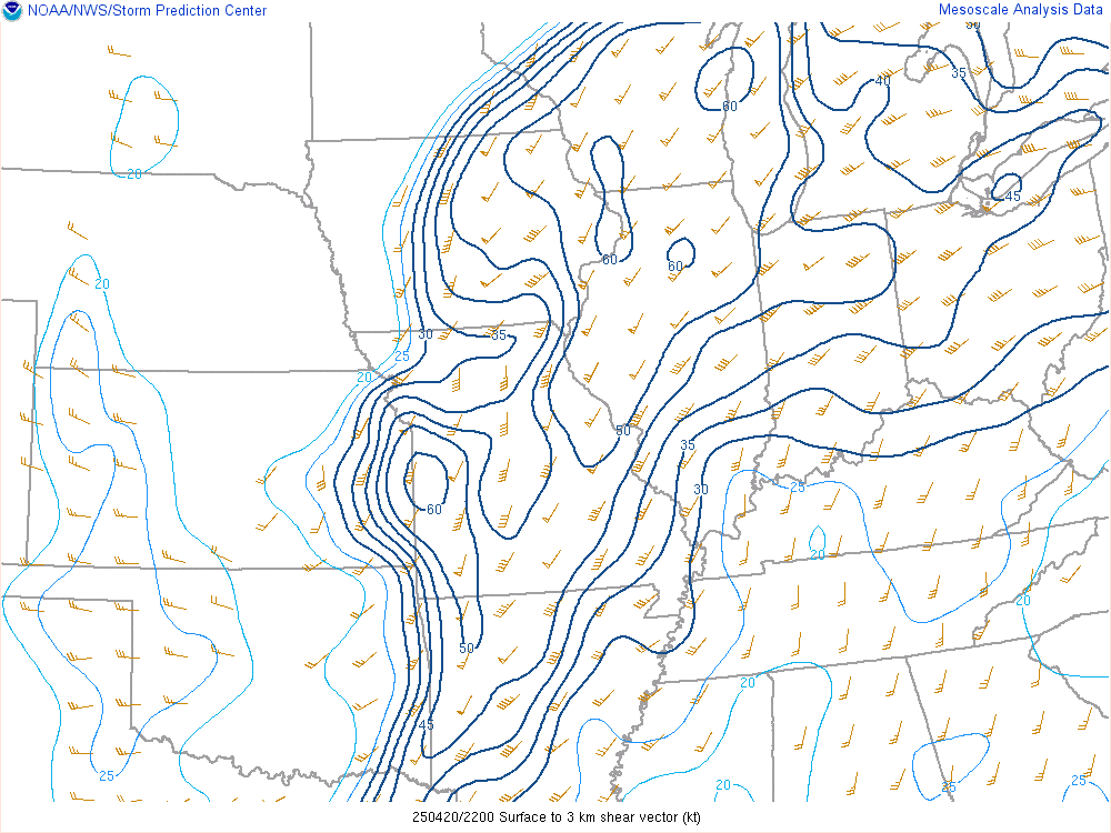
0-6 km Wind Shear Favorable for Organized Convection |
0-3 km Wind Shear Favorable for Mesovortex Development |
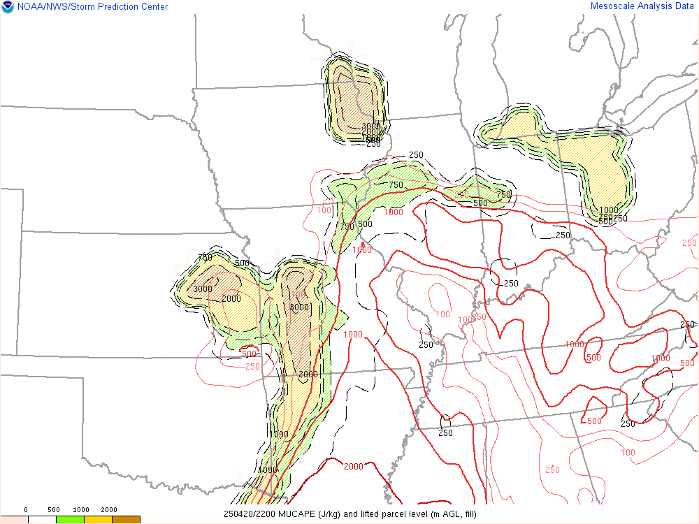
Most Unstable CAPE Instability |
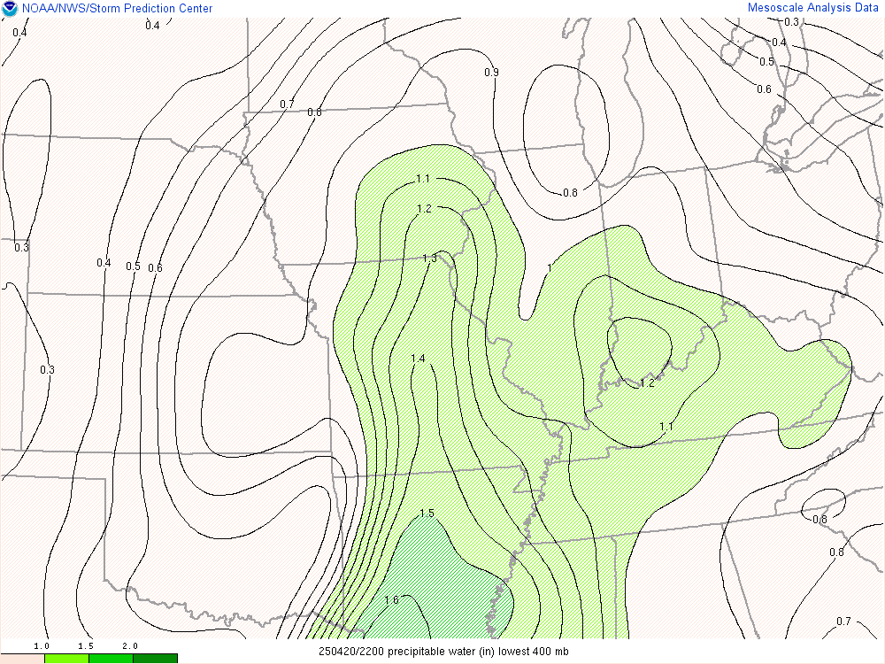
Precipitable Water Favorable for Heavy Rain |
 |
Media use of NWS Web News Stories is encouraged! Please acknowledge the NWS as the source of any news information accessed from this site. |
|