NWS Birmingham, Alabama
Weather Forecast Office
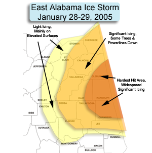
East Alabama Ice Storm - January 28 & 29, 2005
An upper level low pressure system moved out the Southern Plains and into the Southeast United States, bringing abundant gulf moisture into the state of Alabama. The gulf moisture mixed with cold dry air at the surface, which was being funneled into the region from the east. The combination of moisture aloft moving over the colder and drier air at the surface resulted in freezing rain across much of Central and East Central Alabama that lasted from Friday evening, January 28th, until Saturday afternoon, January 29th.
Significant icing occurred across Randolph and Chambers Counties. One quarter to one inch of ice accumulations was reported countywide. Widespread power outages occurred due to icing on power lines, and trees that fell onto power lines, due to the weight of the ice that accumulated on them. Across Cherokee, Etowah, St. Clair, Calhoun, Cleburne, Talladega, Clay, Coosa, Tallapoosa, and Lee counties, widespread icing occurred on elevated and colder surfaces. Reports of ice on trees, bridges and vehicles were common in these areas. Across the higher elevations on Mt. Cheaha, one half to one inch of ice accumulated. No widespread power outages occurred across these areas, although a few weak tree limbs were reported down due to the icing. Light icing occurred as far west as Blount, Jefferson, Shelby, Chilton, Elmore, and Eastern Autauga Counties, with ice forming mainly on elevated and metal surfaces.
Ice on a road sign in Icy conditions at US-431 & CR-13 Powerlines covered with ice, CR-65
Coosa County. in Cleburne County. in Randolph County.
Pine tree covered with ice, Numerous trees bent over, US-431 More tree damage, in northeast
northeast of Wedowee. north of Wedowee. Randolph County.
Ice covered many objects in This fence in Northeast Randolph
Randolph County. was completely covered in ice.
Current Hazards
National Outlooks
Tropical
Local Storm Reports
Public Information Statement
Graphical Hazardous Weather Outlook
Current Conditions
Regional Weather Roundup
Rivers and Lakes
Drought Monitor
Forecasts
Air Quality
Fire Weather
Aviation Weather
Graphical Forecasts
Forecast Discussion
Climate and Past Weather
Past Events
Storm Data
Tornado Database
Daily Rainfall Plots
Tropical Cyclone Reports
Warnings and Other Products
Tornado Warnings
Severe Thunderstorm Warnings
Flash Flood Warnings
Winter Weather Warnings
Special Weather Statements
Non-Precipitation Warnings
Flood/River Flood Warnings
Productos en Español
Conciencia y Preparación
Previsión de 7 Días
Weather Safety
NOAA Weather Radio
Severe Weather Preparedness
Severe Safety Rules
Tornado Safety Rules
Severe Safety w/ ASL
Awareness Weeks
Severe Weather
Hurricane Preparedness
Summer Safety Campaign
Winter Weather
US Dept of Commerce
National Oceanic and Atmospheric Administration
National Weather Service
NWS Birmingham, Alabama
465 Weathervane Road
Calera, AL 35040
205-664-3010
Comments? Questions? Please Contact Us.


