Snowfall of January 17, 2013
During the overnight hours of Wednesday, January 16th, a strong upper low pressure system began moving eastward across Mississippi. Deep gulf moisture combined with the cold core of the system and cold air being pulled in from the north led to a classic snow setup for parts of the Deep South. Rain quickly turned to snow across portions of Mississippi during the overnight hours Wednesday. After dropping several inches of snow across Central and Eastern Mississippi, the system crossed into Alabama on the morning of Thursday, January 17th. The first reports of snow came out of Pickens, Sumter, and Lamar Counties shortly before 7 AM. The rain/snow line quickly progressed eastward across Central Alabama through the day, with the snow ending in the east by 6 PM.
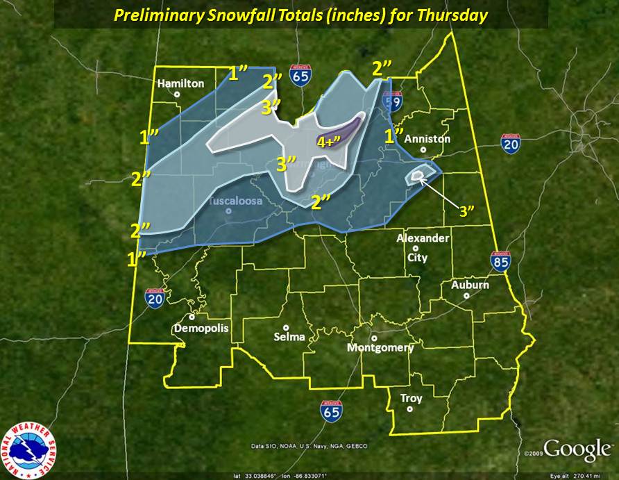
When all was said and done, generally 1 to 3 inches fell across the northern half of the state, with locally higher amounts of 4 to 5 inches also reported. Thundersnow, a very rare occurrance here in the South, was observed with the heaviest snow band as it moved across Tuscaloosa, Walker, Jefferson, and St Clair Counties. Road conditions became hazardous in areas where snow fell quickly and heavily. Icy roadways led to numerous traffic accidents in some counties, and travel came to a halt in a few locations. Road conditions improved by mid morning on Friday as temperatures rose into the 50s, but visible satellite imagery (below) showed that there was still some snow cover on the ground.
Surface Analysis January 17th at 6 AM Surface Analysis January 17th at 6 PM
500 mb Analysis January 17th at 6 AM 500 mb Analysis January 17th at 6 PM
KJAN Sounding January 17th at 6 AM Visible Satellite January 18th at 11 AM
Click here for the Local Storm Reports from the event.
The following map shows a general and preliminary estimate of the snowfall across Central Alabama. Keep in mind that small scale features and micro-climates will lead to varying amounts, even from backyard to backyard and neighborhood to neighborhood.

Courtesy of Myra Blackston in Jasper, AL Courtesy of Karen Beck in Hueytown, AL
Courtesy of James Simms in Tuscaloosa, AL Courtesy of Elizabeth Laera in Bluff Park, AL
Courtesy of Bart Smith in Clay, AL Courtesy of Tara Goggins in Alabaster, AL
Courtesy of Stephan Frank in Munford, AL Courtesy of Sara Price in Blountsville, AL
Courtesy of Heather Hall in Parrish, AL Courtesy of Mallory Stellfox in Jasper, AL
Courtesy of Will Hall on Mount Cheaha Courtesy of Taylor Veazey
at University of Alabama campus
If you have any pictures from this event you would like to share with us, please email them to sr-bmx.pix@noaa.gov. Images can be submitted in any format, but please try to keep the file sizes below 500 Kb. Please include a date and location the image was taken, and a brief description. Although not every detail is needed, be as specific as you can. For proper credit for the image, also include your name and location.