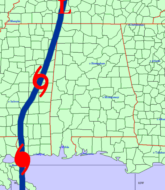
Hurricane Katrina formed near Long Island in the Bahamas on the afternoon of August 23rd, 2005. Katrina reached hurricane strength just before making landfall north of Miami, Florida on the evening on August 25th, 2005. Katrina produced 10 to 20 inches of rain, flooding, tornadoes, and injuries across Far Southern Florida. Katrina moved south-westward across the extreme southern tip of Florida and into the Southeastern Gulf of America. Katrina reached category five in the Central Gulf of America with sustained winds around 175 MPH. This occurred on Sunday, August 28th, 2005. Katrina then turned on a northward path.Hurricane Katrina made landfall along the Gulf Coast early Monday morning August 29th, 2005 as a large category four hurricane. Sustained winds were around 145 MPH in Southeast Louisiana. Katrina continued northward, affecting areas from near New Orleans, Louisiana to near Mobile, Alabama. Devastating damage occurred along the Gulf Coast. Katrina will most likely go down as one of the worst natural disasters in United States history.
Katrina weakened to a tropical storm Monday evening, August 29th, 2005 northwest of Meridian, Mississippi. Katrina continued to move northward across Far Eastern Mississippi overnight, then into Tennessee Tuesday morning. Katrina finally lost its tropical characteristics as it merged with a cold front over Northern Pennsylvania on August 31st, 2005.
Katrina produced local effects that were widespread across Central Alabama. Numerous trees and power lines were downed, minor to major structural damage occurred, and power outages were widespread. Many locations remained without power for a week or more. Storm damage effects across parts of West Central Alabama were worse than what was sustained during Hurricane Ivan in 2004.
Four tornadoes occurred across Central Alabama, two F0s and two F1s. Here is the information on those tornadoes.


| Katrina Path across Louisiana into Tennessee | Katrina Satellite Picture |
Storm total rain amounts of 1 inch or less were measured in the northeast and east central portions of Central Alabama. This was due to dry air wrapping into the circulation of Katrina and diminishing the rain area. Rain totals of 1 to 2 inches were common over the southeast sections. Rainfall amounts of 2 to 4 inches occurred over much of West Alabama, west of interstate 65. Some locations received 5 to 6 inche amounts in the northwest sections, specifially in Lamar and Marion Counties. Below is a storm total rainfall map from rains associated with Katrina.
The highest sustained winds from Katrina ranged from 25 MPH along the Georgia state line to around 65 MPH along the Mississippi state line. Peak wind gusts generally ranged from around 35 MPH to near 80 MPH, with the highest gusts occurring across West Central Alabama and in the highest elevations. Below are some peak wind gusts associated with Katrina.
*** DISCLAIMER *** The information contained below has been quality controlled only for consistency. The accuracy of the equipment used has not been measured. The observations were taken from ASOS, AWOS, AWS, EMA wind equipment and personal wind equipment. Data is sparse across parts of Western Alabama and some areas could have sustained higher winds. This data is preliminary. Additional information will added when received.
Peak Wind Gusts
Location County Speed
(mph)Cuba Sumter 80 Fayette (estimated) Fayette 75 Vance Tuscaloosa 68 Jimmie Hale Mission Jefferson 60 Birmingham Race Course Jefferson 52 Birmingham Airport Jefferson 52 Oakmulgee Bibb 49 Guin Marion 47 Ranburne Cleburne 45 Dannelly Field Montgomery 45 Shelby County Airport (estimated) Shelby 45
Storm Total Rainfall
Location County Rainfall
(inches)Hamilton Marion 4.82 Addison Winston 3.62 Troy Pike 2.18 Selma Dallas 2.00