NWS Birmingham, Alabama
Weather Forecast Office
Leeds Tornado - February 26th, 2008
|
Rating:
(Click for EF Scale) |
EF-1
|
|
Estimated Maximum Wind:
|
100 mph
|
|
Injuries/Fatalities:
|
1 Fatality
|
|
Damage Path Length:
|
2.8miles
|
|
Maximum Path Width:
|
500 yards
|
|
Approximate Start Point:
|
33.5492/-86.5654 at 342 AM
|
|
Approximate End Point:
|
33.5419/-86.5175 at 345 AM
|
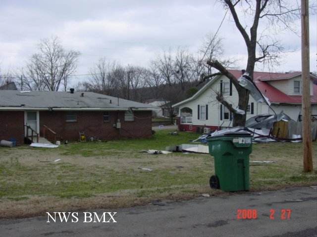
A National Weather Service Damage Assessment Team has surveyed the storm damage in Leeds and in eastern Jefferson County. After investigating a very complex pattern of widespread damage with both a ground survey team and an aerial survey, the team determined the damage was a result of a tornado. The tornado has been rated an EF-1 on the Enhanced Fujita Scale. Damage estimates were consistent with winds around 100 mph.
The tornado damage path was approximately 2.8 miles long and 500 yards wide at its widest point. The tornado touched down east of Interstate 20 near Henry Ellen Rd...where trees falling on a mobile home caused a fatality. The tornado tracked east-southeastward at a heading of 100 degrees...roughly between the railroad tracks and Highway 78 towards the city center. There was significant roof damage to several buildings along Highway 78 from Leeds City Park in the downtown area...windows were blown out of several businesses...buildings were partially de-roofed...and the brick facade of one building was collapsed. The old rock wool warehouse facility received major... irreparable damage. The most concentrated and significant material damage occured near Leeds High School. Fencing around the girls softball field was mangled and twisted...and a large batting catch was overturned and rolled. Tall wooden utility poles with field lighting were snapped half way up. Several homes just to the east of the athletic fields received significant damage. Witnesses in the area reported hearing a freight train.
Over the path of this tornado...an estimated 30 to 40 homes and 20 to 30 businesses were damaged or destroyed. Several hundred trees were either snapped off or were uprooted along the path. No other injuries were reported. A Severe Thunderstorm Watch was in effect at the time... and a Severe Thunderstorm Warning was in effect from 323 am until 4 am.
Special thanks to the Leeds Police Department for assisting in this storm survey.
Current Hazards
National Outlooks
Tropical
Local Storm Reports
Public Information Statement
Graphical Hazardous Weather Outlook
Current Conditions
Regional Weather Roundup
Rivers and Lakes
Drought Monitor
Forecasts
Forecast Discussion
Air Quality
Fire Weather
Aviation Weather
Graphical Forecasts
Climate and Past Weather
Past Events
Storm Data
Tornado Database
Daily Rainfall Plots
Tropical Cyclone Reports
Warnings and Other Products
Tornado Warnings
Severe Thunderstorm Warnings
Flash Flood Warnings
Winter Weather Warnings
Special Weather Statements
Non-Precipitation Warnings
Flood/River Flood Warnings
Productos en Español
Conciencia y Preparación
Previsión de 7 Días
Weather Safety
NOAA Weather Radio
Severe Weather Preparedness
Severe Safety Rules
Tornado Safety Rules
Severe Safety w/ ASL
Awareness Weeks
Severe Weather
Hurricane Preparedness
Summer Safety Campaign
Winter Weather
US Dept of Commerce
National Oceanic and Atmospheric Administration
National Weather Service
NWS Birmingham, Alabama
465 Weathervane Road
Calera, AL 35040
205-664-3010
Comments? Questions? Please Contact Us.


