NWS Birmingham, Alabama
Weather Forecast Office
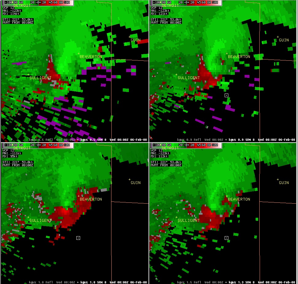
EF-1 Beaverton - Guin Tornado - February 6, 2008
|
Rating:
(Click for EF Scale) |
EF-1
|
|
Maximum Wind:
|
90 mph
|
|
Injuries/Fatalities:
|
None
|
|
Path Length:
|
7.3 miles
|
|
Maximum Path Width:
|
150 Yards
|
|
Start:
|
33.93/-88.03 at 204 AM
|
|
End:
|
33.99/-87.93 at 213 AM
|
This supercell thunderstorm developed near Louisville, Mississippi in Winston County. The storm tracked northeastward near Starkville, Columbus Air Force Base, and Caledonia before entering western Pickens County near the Bedford Community. The storm then moved just south of Sulligent. Preliminary data suggest this supercell storm had not produced any damage to this point but surveys are still underway.
A tornado then touched down just southwest of Beaverton along US Highway 278. The tornado tracked northeast and produced damage in Beaverton. The metal roof of the Post Office was blown off and City Hall also sustained roof damage. Several hardwood trees were uprooted and many more softwood trees were snapped off along the path. One large tree fell and destroyed a barn. A few homes suffered significant damage from downed trees. A few roads were temporarily closed due to the fallen trees. The tornado roughly paralleled US 278 and crossed into Marion County. The tornado lifted after crossing County Road 16 but before US Highway 43. The tornado damage path was 7.3 miles long and was 150 yards wide at its widest point.
In Beaverton, two trains were stranded on the tracks due to a power outage. The conductors were aware of the tornado warnings because they said they heard the tornado sirens about 20 minutes before the storm hit. One of the railroad personnel apparently witnessed the tornado. A sheriffs deputy spotted a funnel cloud just before the tornado touched down.
This supercell thunderstorm continued northeastward into the Tennessee Valley and produced a violent EF-4 tornado in Lawrence and Morgan Counties
Current Hazards
National Outlooks
Tropical
Local Storm Reports
Public Information Statement
Graphical Hazardous Weather Outlook
Current Conditions
Regional Weather Roundup
Rivers and Lakes
Drought Monitor
Forecasts
Aviation Weather
Graphical Forecasts
Forecast Discussion
Air Quality
Fire Weather
Climate and Past Weather
Past Events
Storm Data
Tornado Database
Daily Rainfall Plots
Tropical Cyclone Reports
Warnings and Other Products
Tornado Warnings
Severe Thunderstorm Warnings
Flash Flood Warnings
Winter Weather Warnings
Special Weather Statements
Non-Precipitation Warnings
Flood/River Flood Warnings
Productos en Español
Conciencia y Preparación
Previsión de 7 Días
Weather Safety
NOAA Weather Radio
Severe Weather Preparedness
Severe Safety Rules
Tornado Safety Rules
Severe Safety w/ ASL
Awareness Weeks
Severe Weather
Hurricane Preparedness
Summer Safety Campaign
Winter Weather
US Dept of Commerce
National Oceanic and Atmospheric Administration
National Weather Service
NWS Birmingham, Alabama
465 Weathervane Road
Calera, AL 35040
205-664-3010
Comments? Questions? Please Contact Us.


