|
|
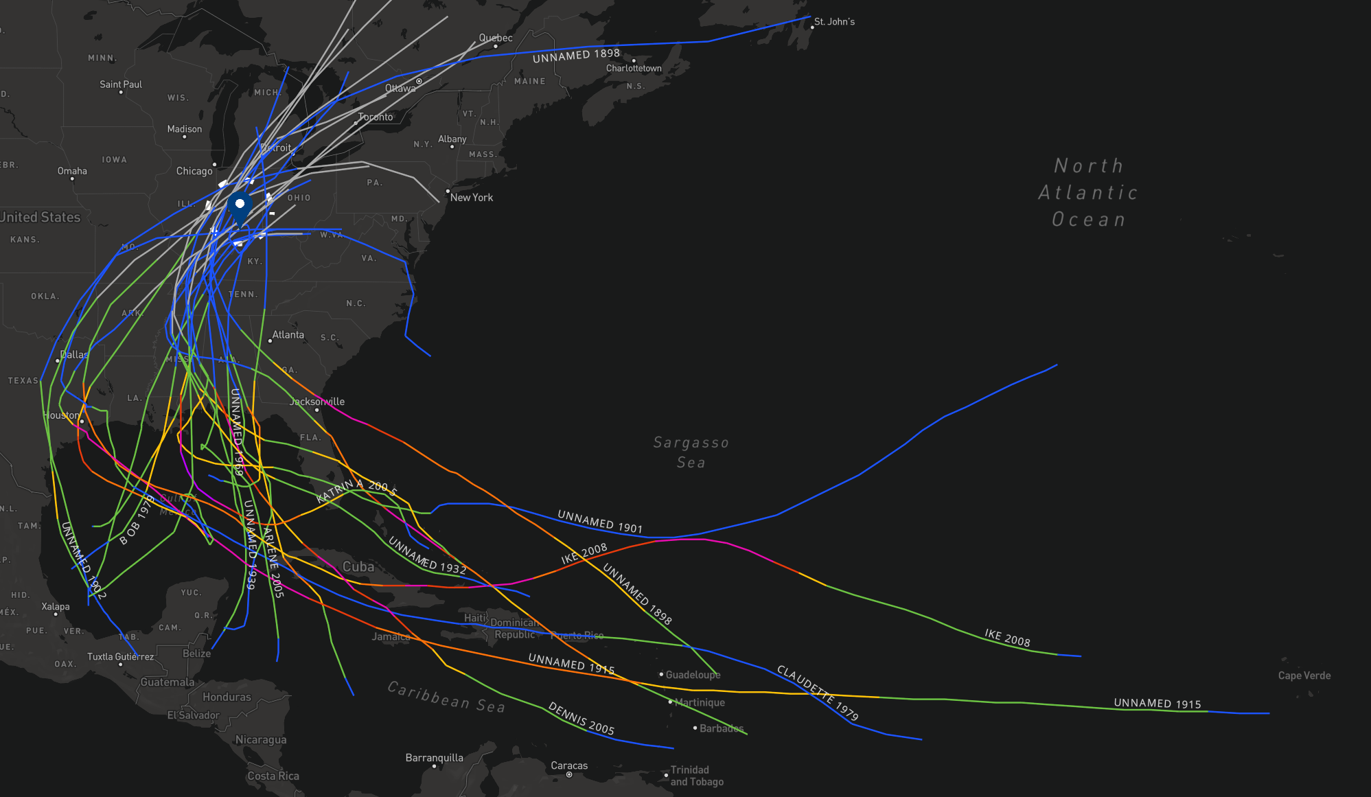
Tropical cyclone (an organized area of low pressure that develops over tropical waters) remnants can move into central Indiana. The most common impact to central Indiana from these remnants is rainfall, sometimes heavy. However, they can bring damaging winds and help spawn tornadoes. The remnants of Hurricane Ike brought damaging winds to central Indiana in 2008. The NOAA Office for Coastal Management has a searchable archive for tropical system tracks. Figure 1 is a static map of systems that moved across Indiana. For this search for systems near central Indiana, any system that originated in the North Atlantic Basin and moved within 100 miles (87 nautical miles) of the center of Indianapolis was considered. There were 23 systems whose remnant low pressure areas moved nearby central Indiana from 1866-2024 Figure 2 is a static map of the systems that moved within 100 miles of Indianapolis. Most of the systems have their names plotted on the map. Current tropical systems are monitored by the National Hurricane Center. See farther down the page for details about the systems impacting the area. |
| Name | Tropical Cyclone Dates | Central Indiana Date* | Indianapolis Rainfall** |
| Unnamed | May 24 to May 31, 1863 | Unknown | Unknown |
| Unnamed | Sep 25 to Oct 6, 1898 | Oct 4 | 0.75" |
| Unnamed | Aug 2 to Aug 18, 1901 | Aug 18 | 1.09" |
| Unnamed | Jun 21 to Jun 29, 1902 | Jun 28-29 | 2.44" |
| Unnamed | Aug 5 to Aug 23, 1915 | Aug 20-21 | 1.46" |
| Unnamed | Aug 31 to Sep 6, 1915 | Sep 6-7 | 0.34" |
| Unnamed | Oct 16 to Oct 21, 1923 | Oct 18 | 2.15" |
| Unnamed | Jul 22 to Aug 2, 1926 | Aug 1 | 1.58" |
| Unnamed | Aug 26 to Sep 4, 1932 | Sep 3 | 2.00" |
| Unnamed | Sep 18 to Sep 21, 1932 | Sep 20-21 | 1.45" |
| Unnamed | Jun 12 to Jun 18, 1939 | Jun 17-18 | 0.01" |
| Unnamed | Sep 17 to Sep 27, 1941 | Sep 25 | 0.16" |
| Unnamed | Sep 1 to Sep 6, 1948 | Sep 5-6 | 1.48" |
| Candy | Jun 22 to Jun 26. 1968 | Jun 25 | 0.71" |
| Bob | Jul 9 to Jul 16, 1979 | Jul 12-13 | 4.36" |
| Claudette | Jul 15 to Jul 29, 1979 | Jul 28 | 2.95" |
| Erin | Jul 31 to Aug 06, 1995 | Aug 5-6 | 0.35" |
| Arlene | Jun 8 to Jun 14, 2005 | Jun 12-13 | 3.12" |
| Dennis | Jul 4 to Jul 18, 2005 | Jul 12-16 | 1.27" |
| Katrina | Aug 23 to Aug 31, 2005 | Aug 30 | 2.16" |
| Ike | Sep 1 to Sep 15, 2008 | Sep 14 | 0.22" |
| Alberto | May 25 to May 31, 2018 | May 30 | 0.26" |
| Beryl | Jun 28 to Jul 11, 2024 | Jul 9-10 | 1.28" |
* - dates are approximate
** - Rainfall may be influenced by other systems. Rain may have fallen on dates on either side of those listed due to other systems
Indianapolis was chosen due to its longer period of record for rainfall data.
The multiple tropical remnants in 1979 caused significant flash flooding in parts of central Indiana. See this excerpt from the Storm Data publication for details.
Thanks to WFO Chicago for the inspiration for this page..