Overview
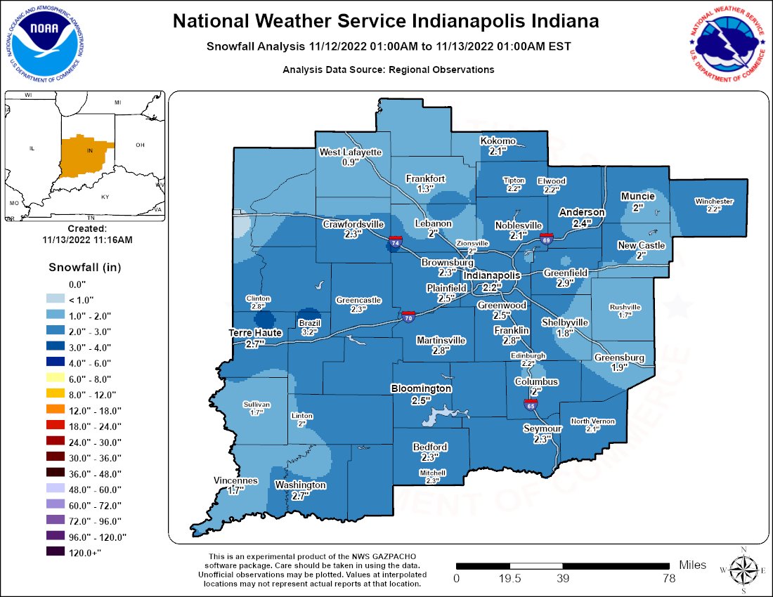
An upper level system brought snow to central Indiana on November 12. Snowfall amounts up to around 3 inches were recorded. Indianapolis set a new record snowfall for the date of November 12, with 2.7".Snow/Ice
Below is a map of snowfall. A text listing of reports received by NWS Indy follows the map.

Public Information Statement
National Weather Service Indianapolis IN
1046 AM EST Sun Nov 13 2022

...SNOWFALL REPORTS...

Location                     Amount    Time/Date

...Indiana...

...Bartholomew County...
Taylorsville 0.8 SSW         1.7 in    0430 AM 11/13

...Boone County...
New Ross 2.0 E               3.3 in    0700 AM 11/13

...Brown County...
(W9DBA)Morgantown 6.7 SSE    2.8 in    0600 AM 11/13

...Clay County...
3 N Brazil                   3.3 in    1225 PM 11/12
Jasonville 4.0 ENE           2.2 in    0742 AM 11/13

...Clinton County...
3 W Kirklin                  2.6 in    0714 AM 11/13
Frankfort 4.9 NNE            1.8 in    0700 AM 11/13
Frankfort 0.9 SSE            1.7 in    0700 AM 11/13

...Daviess County...
Plainville 1.3 S             1.5 in    0700 AM 11/13

...Decatur County...
(KB9CIY)Greensburg 6.0 SW    2.0 in    0700 AM 11/13

...Greene County...
Solsberry 4.0 ESE            3.0 in    0700 AM 11/13

...Hamilton County...
Mccordsville 2.6 NE          2.9 in    0700 AM 11/13
Noblesville                  2.5 in    0150 PM 11/12
Westfield 1.4 ESE            2.1 in    0712 AM 11/13

...Hancock County...
1 E Mccordsville             2.6 in    1253 PM 11/12
5 N Greenfield               1.9 in    1140 AM 11/12

...Hendricks County...
Clayton 0.4 WNW              3.0 in    0700 AM 11/13
Danville 3sw                 2.5 in    0700 AM 11/13
Avon                         2.3 in    1226 PM 11/12
Avon 1.6 NNW                 2.2 in    0700 AM 11/13

...Henry County...
New Castle 3.2 W             2.2 in    0700 AM 11/13
2.4 SW New Castle            1.9 in    0700 AM 11/13

...Johnson County...
Greenwood 3.8 W              2.8 in    0700 AM 11/13
Greenwood 4.9 SW             2.2 in    0700 AM 11/13

...Knox County...
4 E Vincennes                2.6 in    1051 AM 11/12
Vincennes 4 E                1.6 in    0700 AM 11/13

...Lawrence County...
1.7 S Avoca                  2.4 in    0700 AM 11/13
3 ENE Oolitic                2.2 in    1208 PM 11/12
Bedford 3.7 N                2.2 in    0700 AM 11/13

...Madison County...
Anderson 0.4 ESE             2.5 in    0700 AM 11/13
Anderson 4.0 N               2.2 in    0700 AM 11/13
1 NNE Anderson               1.7 in    1107 AM 11/12

...Marion County...
Speedway                     3.1 in    0149 PM 11/12
1 SSE Indianapolis Int`l Air 2.7 in    0108 PM 11/12
Speedway 6.2 SSW             2.7 in    0700 AM 11/13
Speedway 0.3 W               2.7 in    0800 AM 11/13
3 E Southport                2.6 in    0101 PM 11/12
Castleton 2s                 2.6 in    0700 AM 11/13
Indianapolis 4.4 N           2.2 in    0700 AM 11/13
Indianapolis 9.8 WNW         2.2 in    0700 AM 11/13
1 SSE Indianapolis Int`l Air 1.9 in    1045 AM 11/12

...Monroe County...
Bloomington 6.5 WNW          2.5 in    0800 AM 11/13
(KC9RPX)Ellettsville 0.5 W   2.4 in    0700 AM 11/13
Bloomington 7.1 E            2.1 in    0800 AM 11/13

...Montgomery County...
2 S Crawfordsville           2.6 in    1046 AM 11/12
1.1 NW New Market            2.4 in    0700 AM 11/13

...Morgan County...
(N9JPX)Paragon 3.2 ENE       3.0 in    0700 AM 11/13
Martinsville 2.3 SE          2.8 in    0700 AM 11/13
Mooresville 3.8 NE           2.4 in    0700 AM 11/13
Brooklyn 0.5 ENE             1.6 in    0820 AM 11/13

...Owen County...
4 SW Stinesville             2.2 in    1234 PM 11/12
Spencer 7.0 S                1.8 in    0700 AM 11/13

...Parke County...
2 NNE Bloomingdale           2.6 in    1122 AM 11/12

...Putnam County...
Greencastle 3.6 ESE          2.0 in    0800 AM 11/13

...Randolph County...
(KC9FXU) Winchester 2.2 WSW  2.2 in    0700 AM 11/13

...Rush County...
Rushville                    1.7 in    1154 AM 11/12
Homer 0.4 NE                 1.5 in    0700 AM 11/13
Morristown 3.8 ENE           1.2 in    0800 AM 11/13

...Shelby County...
(KB9RBB)Fairland 0.9 SSW     2.0 in    0700 AM 11/13
Shelbyville 1.6 SSE          1.8 in    0700 AM 11/13

...Tippecanoe County...
Lafayette 2.2 S              1.2 in    0700 AM 11/13
Lafayette 1.0 WNW            0.8 in    0630 AM 11/13

...Tipton County...
5.1 SE Goldsmith             2.2 in    0600 AM 11/13

...Vermillion County...
0.7 SW Gessie                0.7 in    0600 AM 11/13

...Vigo County...
1 NNW North Terre Haute      3.3 in    0145 PM 11/12
1 NNE Seelyville             2.8 in    1111 AM 11/12
Indiana State University     2.7 in    1254 PM 11/12
2 N North Terre Haute        2.5 in    0900 AM 11/12

Observations are collected from a variety of sources with varying
equipment and exposures. We thank all volunteer weather observers
for their dedication. Not all data listed are considered official.
Environment
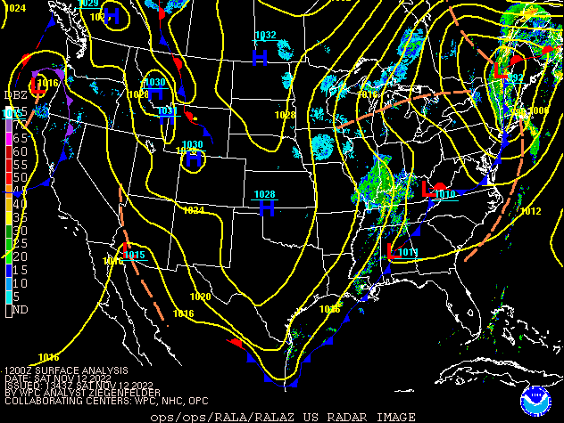
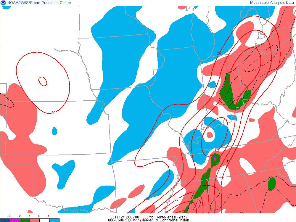
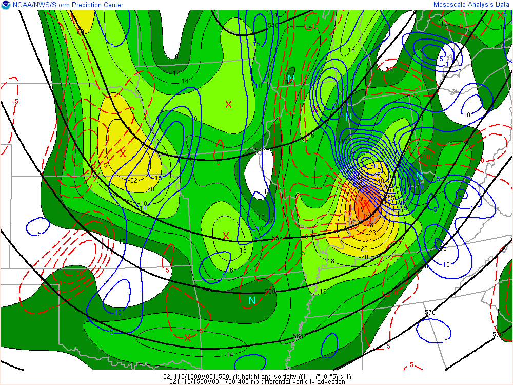
An upper level system brought snow to the area. Frontogenetical forcing allowed bands of heavier snow to fall.
 |
 |
 |
| Figure 1: Surface Map/Radar at 7 AM EST | Figure 2: Frontogenetical forcing and EPV at 7 AM | Figure 3: 500mb Heights and Layer Vorticity Advection at 10 AM EST |
 |
Media use of NWS Web News Stories is encouraged! Please acknowledge the NWS as the source of any news information accessed from this site. |
 |