Overview
|
Thunderstorms developed in warm and unstable air well ahead of an approaching cold front. These storms produced damaging winds and hail up to golf ball size. |
Tornadoes
Select a tornado from the table to zoom into the track and view more information. The default table view is limited to 8 tracks, but can be scrolled by a mouse wheel or dynamically expanded. Additionally, the table can fill the entire window by clicking the small circular expanding arrow icon at the very top right of the table and returned to its original size by clicking the button again. The side information panel that opens over the map can be closed using the "X" on the upper right corner of the pop-up. Zoom into the map and click damage points to see detailed information and pictures from the surveys.
|
NOTE: times shown below are local to your device's time zone. |

The Enhanced Fujita (EF) Scale classifies tornadoes into the following categories:
| EF0 Weak 65-85 mph |
EF1 Moderate 86-110 mph |
EF2 Significant 111-135 mph |
EF3 Severe 136-165 mph |
EF4 Extreme 166-200 mph |
EF5 Catastrophic 200+ mph |
 |
|||||
| Tornadoes that fail to impact any ratable structures on the EF-Scale are rated EF-Unknown (EF-U) | |||||
Storm Reports
Note: Survey teams determined that the damage in Monroe, Brown, and Bartholomew Counties was caused by straight line winds of 65-85 mph.
Preliminary Local Storm Report...Summary
National Weather Service Indianapolis IN
941 PM EDT Sun Mar 30 2025
..TIME... ...EVENT... ...CITY LOCATION... ...LAT.LON...
..DATE... ....MAG.... ..COUNTY LOCATION..ST.. ...SOURCE....
..REMARKS..
0230 PM Tstm Wnd Dmg Williamsport 40.29N 87.29W
03/30/2025 Warren IN Emergency Mngr
Barn and tree damage across the county.
0310 PM Tstm Wnd Dmg Delphi 40.59N 86.67W
03/30/2025 Carroll IN Emergency Mngr
A few structures sustained minor damage
across the county.
0326 PM Tstm Wnd Dmg 1 W Perrysville 40.05N 87.45W
03/30/2025 Vermillion IN Public
Trees down.
0330 PM Tstm Wnd Dmg 3 N Perrysville 40.10N 87.44W
03/30/2025 Vermillion IN CO-OP Observer
Utility lines were blown down. Time
estimated from radar.
0340 PM Tstm Wnd Dmg Clarks Hill 40.25N 86.73W
03/30/2025 Tippecanoe IN Emergency Mngr
Large tree branches down onto house...no
apparent damage. Damage to barn doors. Time
estimated from radar.
0344 PM Tstm Wnd Dmg 2 NW West Lafayette 40.47N 86.94W
03/30/2025 Tippecanoe IN Public
0345 PM Tstm Wnd Dmg 1 W Purdue University 40.43N 86.92W
03/30/2025 Tippecanoe IN Trained Spotter
Time estimated from radar. Southwest corner
of Purdue University there are branches up
to inch in diameter blown down by
thunderstorm winds.
0348 PM Hail Rockville 39.76N 87.24W
03/30/2025 M0.70 Inch Parke IN Fire Dept/Rescue
Report from Rockville Fire Department.
0350 PM Tstm Wnd Dmg Romney 40.25N 86.90W
03/30/2025 Tippecanoe IN Public
Considerable siding off a home. Time
estimated from radar.
0351 PM Tstm Wnd Dmg Waveland 39.88N 87.05W
03/30/2025 Montgomery IN Public
Trees down.
0353 PM Tstm Wnd Dmg New Market 39.95N 86.92W
03/30/2025 Montgomery IN Public
Tree down.
0354 PM Tstm Wnd Dmg 2 NE Lafayette 40.44N 86.85W
03/30/2025 Tippecanoe IN Public
0359 PM Tstm Wnd Dmg 1 S Romney 40.24N 86.90W
03/30/2025 Tippecanoe IN Public
Siding damaged by thunderstorm wind gusts.
0400 PM Hail Clarks Hill 40.25N 86.72W
03/30/2025 E0.25 Inch Tippecanoe IN Amateur Radio
Time is approximate. Hail covers the ground.
0400 PM Tstm Wnd Gst 4 ENE Lafayette 40.44N 86.81W
03/30/2025 M70 MPH Tippecanoe IN Public
Three trees blown down by thunderstorm winds
measured at 70 mph by an anemometer at the
site.
0400 PM Tstm Wnd Dmg 4 ENE Lafayette 40.44N 86.81W
03/30/2025 Tippecanoe IN Public
Three trees blown down by thunderstorm winds
measured at 70 mph by an anemometer at the
site.
0401 PM Tstm Wnd Gst 4 S Delphi 40.53N 86.68W
03/30/2025 M64 MPH Carroll IN Public
0410 PM Tstm Wnd Gst 4 SW Seelyville 39.45N 87.31W
03/30/2025 M60 MPH Vigo IN ASOS
0413 PM Tstm Wnd Dmg Colfax 40.19N 86.67W
03/30/2025 Clinton IN Public
Delayed report...Top edge of brick facade on
front of a building extending above the roof
line was damaged.
0417 PM Hail 1 S Mulberry 40.33N 86.67W
03/30/2025 E0.25 Inch Clinton IN Trained Spotter
0428 PM Non-Tstm Wnd Dmg 1 ENE Clarks Hill 40.25N 86.70W
03/30/2025 Tippecanoe IN Emergency Mngr
EM Reports Tree damage throughout county;
Some poles down throughout the County. A few
roofs off some buildings across the County.
0445 PM Tstm Wnd Dmg Kempton 40.29N 86.23W
03/30/2025 Tipton IN Public
Power pole snapped.
0445 PM Tstm Wnd Dmg 1 NE Indian Heights 40.44N 86.10W
03/30/2025 Howard IN Trained Spotter
Trees blown down by thunderstorm winds.
0450 PM Tstm Wnd Dmg 3 NW Russiaville 40.45N 86.31W
03/30/2025 Howard IN Emergency Mngr
EMA trained spotter reports 16-inch measured
diameter tree down 100yds west of 950 W 150
S in Howard County.
0453 PM Hail 2 N North Terre Haute 39.57N 87.36W
03/30/2025 E0.50 Inch Vigo IN Public
Report from mPING: Half-inch (0.50 in.).
0457 PM Tstm Wnd Dmg 4 E Russiaville 40.42N 86.19W
03/30/2025 Howard IN Amateur Radio
Ham trained spotter reports 24-inch dia.
tree down just east of IN26 and 350 W on the
south side of the road.
0458 PM Hail 1 NW Indian Heights 40.44N 86.13W
03/30/2025 E0.25 Inch Howard IN Public
0502 PM Hail 3 SSE West Terre Haute 39.42N 87.43W
03/30/2025 E0.25 Inch Vigo IN Amateur Radio
Pea size hail 4 miles south of the prison in
Vigo County.
0503 PM Hail 4 N Pimento 39.37N 87.39W
03/30/2025 E0.25 Inch Vigo IN Public
0505 PM Hail 4 ENE Prairieton 39.40N 87.41W
03/30/2025 E1.00 Inch Vigo IN Amateur Radio
Pea to quarter size hail at my location
along US 41 near Walmart in Terre
Haute....40 MPH wind, torrential rain.
0506 PM Hail 2 SE Indiana State Univ 39.44N 87.40W
03/30/2025 E0.75 Inch Vigo IN Public
Report from mPING: Dime (0.75 in.).
0506 PM Hail 2 SE Indiana State Univ 39.44N 87.40W
03/30/2025 E0.75 Inch Vigo IN Public
0507 PM Hail Terre Haute 39.47N 87.41W
03/30/2025 E0.75 Inch Vigo IN Public
Spotter Reports Hail.
0507 PM Hail 2 S Indiana State Unive 39.44N 87.40W
03/30/2025 E0.50 Inch Vigo IN Public
Report from mPING: Half-inch (0.50 in.).
0508 PM Hail 2 SSE Terre Haute 39.45N 87.37W
03/30/2025 E0.25 Inch Vigo IN Amateur Radio
Hulman and Brown streets.
0508 PM Hail 2 NE Terre Haute 39.49N 87.36W
03/30/2025 E0.25 Inch Vigo IN Amateur Radio
0509 PM Hail 2 E Terre Haute 39.47N 87.35W
03/30/2025 M1.00 Inch Vigo IN Cocorahs
0514 PM Hail 3 E Terre Haute 39.46N 87.33W
03/30/2025 E1.00 Inch Vigo IN Public
Report from mPING: Quarter (1.00 in.).
0514 PM Hail Elwood 40.28N 85.84W
03/30/2025 E0.25 Inch Madison IN Public
Approximate location.
0517 PM Hail 3 E Terre Haute 39.46N 87.33W
03/30/2025 M1.50 Inch Vigo IN Public
Near intersection of Poplar and Highway 46.
0522 PM Hail Brazil 39.52N 87.12W
03/30/2025 E0.70 Inch Clay IN Amateur Radio
0537 PM Hail Greencastle 39.64N 86.84W
03/30/2025 E0.88 Inch Putnam IN Public
0539 PM Hail 2 E Terre Haute 39.47N 87.35W
03/30/2025 E1.00 Inch Vigo IN Public
Corrects previous hail report from 2 E Terre
Haute. Approximate location.
0542 PM Hail 2 SE Pittsboro 39.84N 86.44W
03/30/2025 E0.25 Inch Hendricks IN Amateur Radio
0542 PM Hail 1 SW Cicero 40.11N 86.03W
03/30/2025 E0.25 Inch Hamilton IN Public
0545 PM Hail Fillmore 39.67N 86.75W
03/30/2025 E1.00 Inch Putnam IN Public
0548 PM Hail Sullivan 39.10N 87.41W
03/30/2025 E0.25 Inch Sullivan IN Emergency Mngr
0548 PM Hail 1 NE Greencastle 39.65N 86.83W
03/30/2025 E0.50 Inch Putnam IN Public
Report from mPING: Half-inch (0.50 in.).
0551 PM Hail 1 NE Greencastle 39.65N 86.83W
03/30/2025 E0.50 Inch Putnam IN Public
Report from mPING: Half-inch (0.50 in.).
0554 PM Hail 3 NNE Coatesville 39.72N 86.65W
03/30/2025 E0.75 Inch Hendricks IN Amateur Radio
0556 PM Hail 1 E Hymera 39.19N 87.28W
03/30/2025 E0.70 Inch Sullivan IN Amateur Radio
0558 PM Hail Carlisle 38.96N 87.40W
03/30/2025 E0.70 Inch Sullivan IN Amateur Radio
0600 PM Hail Sullivan 39.10N 87.41W
03/30/2025 E1.00 Inch Sullivan IN Amateur Radio
0600 PM Hail Carlisle 38.96N 87.40W
03/30/2025 E1.00 Inch Sullivan IN Amateur Radio
0601 PM Hail Cory 39.38N 87.21W
03/30/2025 E0.25 Inch Clay IN Amateur Radio
0604 PM Tstm Wnd Dmg Bruceville 38.76N 87.41W
03/30/2025 Knox IN Emergency Mngr
Tree down at Camp Arthur Rd and SR 550 north
of Bruceville reported to 911 center.
0607 PM Tstm Wnd Gst Bicknell 38.78N 87.31W
03/30/2025 E70 MPH Knox IN Trained Spotter
0609 PM Hail 3 S Brownsburg 39.80N 86.40W
03/30/2025 M0.50 Inch Hendricks IN Public
Report from mPING: Half-inch (0.50 in.).
0610 PM Hail 1 NE Avon 39.77N 86.37W
03/30/2025 E0.50 Inch Hendricks IN Public
Report from mPING: Half-inch (0.50 in.).
0616 PM Hail Linton 39.04N 87.16W
03/30/2025 E0.50 Inch Greene IN Public
0618 PM Tstm Wnd Dmg Bicknell 38.77N 87.31W
03/30/2025 Knox IN Emergency Mngr
Corrects previous tstm wnd dmg report from
Bicknell. Tree down onto a car from
thunderstorm winds.
0618 PM Tstm Wnd Dmg Freelandville 38.87N 87.30W
03/30/2025 Knox IN Emergency Mngr
Tree blown down by thunderstorm winds.
0624 PM Tstm Wnd Gst Odon 38.84N 86.99W
03/30/2025 E60 MPH Daviess IN Trained Spotter
Delayed report.
0624 PM Hail 1 N Monrovia 39.59N 86.48W
03/30/2025 E0.50 Inch Morgan IN Public
Report from mPING: Half-inch (0.50 in.).
0625 PM Hail Lyons 38.99N 87.08W
03/30/2025 M0.70 Inch Greene IN Trained Spotter
0626 PM Hail Lyons 38.99N 87.08W
03/30/2025 E1.75 Inch Greene IN Amateur Radio
0630 PM Hail 3 NE Warren Park 39.82N 86.04W
03/30/2025 E0.75 Inch Marion IN Public
Report from mPING: Dime (0.75 in.).
0631 PM Hail 4 W Fortville 39.96N 85.91W
03/30/2025 E0.25 Inch Hamilton IN Public
Brief. Few pellets of pea sized hail.
0633 PM Hail 2 N Warren Park 39.81N 86.05W
03/30/2025 E0.25 Inch Marion IN Amateur Radio
0635 PM Hail 3 NE Ellettsville 39.26N 86.59W
03/30/2025 E0.75 Inch Monroe IN Public
Report from mPING: Dime (0.75 in.).
0635 PM Hail Spencer 39.29N 86.77W
03/30/2025 E1.00 Inch Owen IN Amateur Radio
0639 PM Hail 2 NE Warren Park 39.80N 86.03W
03/30/2025 E0.25 Inch Marion IN Public
0639 PM Hail 2 NW Gosport 39.36N 86.69W
03/30/2025 M0.25 Inch Owen IN Amateur Radio
0640 PM Hail 4 W Homecroft 39.67N 86.20W
03/30/2025 M0.75 Inch Marion IN Public
Report from mPING: Dime (0.75 in.).
0640 PM Tstm Wnd Dmg 2 NE Monroe Reservoir 39.09N 86.42W
03/30/2025 Monroe IN Amateur Radio
Delayed report...Damage near Lake Monroe on
IN-446. A large tree over the roadway. Farm
in the area was reported to have roof damage
to a barn. time estimated from radar.
0644 PM Hail 3 S Paragon 39.35N 86.56W
03/30/2025 E0.25 Inch Morgan IN Cocorahs
0644 PM Hail Fortville 39.93N 85.84W
03/30/2025 E0.25 Inch Hancock IN Public
0645 PM Hail 1 NW Beech Grove 39.73N 86.10W
03/30/2025 E0.50 Inch Marion IN Public
0645 PM Tstm Wnd Dmg Bicknell 38.78N 87.31W
03/30/2025 Knox IN Amateur Radio
Large tree branches down onto a house at 206
W 10th St.
0647 PM Hail 3 E Beech Grove 39.72N 86.03W
03/30/2025 E0.75 Inch Marion IN Public
Report from mPING: Dime (0.75 in.).
0648 PM Hail Owensburg 38.92N 86.73W
03/30/2025 E0.25 Inch Greene IN Amateur Radio
0650 PM Tstm Wnd Dmg 1 WSW Lake Lemon 39.26N 86.41W
03/30/2025 Monroe IN Emergency Mngr
*** 1 INJ ***
A tree was blown onto a mobile home, causing
brief entrapment and a minor injury to an
individual.
0653 PM Hail 4 SE Bedford 38.83N 86.44W
03/30/2025 E1.00 Inch Lawrence IN Public
0654 PM Hail Mitchell 38.74N 86.48W
03/30/2025 E0.75 Inch Lawrence IN Amateur Radio
0700 PM Tstm Wnd Gst 1 W Spurgeons Corner 39.07N 86.16W
03/30/2025 M68 MPH Brown IN Public
Tree branches snapped. Trampoline Thrown 100
yards. Time estimated from radar.
0704 PM Tstm Wnd Dmg 1 N Shoals 38.68N 86.79W
03/30/2025 Martin IN Public
MCSD reports power line and tree
down...blocking West River Rd in Shoals.
0705 PM Tstm Wnd Dmg 3 SW Nashville 39.18N 86.27W
03/30/2025 Brown IN Amateur Radio
West Gate of the Brown County State
Park......Brown County....numerous tree tops
taken out and trees toppled...unknown number
at this time.
0713 PM Tstm Wnd Gst 1 SSW Indianapolis Int` 39.71N 86.30W
03/30/2025 M60 MPH Marion IN ASOS
0720 PM Hail 4 SW Columbus 39.17N 85.96W
03/30/2025 M0.50 Inch Bartholomew IN Public
Report from mPING: Half-inch (0.50 in.).
0720 PM Tstm Wnd Gst 1 NW Taylorsville 39.31N 85.96W
03/30/2025 E60 MPH Bartholomew IN Amateur Radio
0722 PM Hail Farmland 40.19N 85.13W
03/30/2025 M0.50 Inch Randolph IN Public
Report from mPING: Half-inch (0.50 in.).
0723 PM Hail 4 NE Seymour 38.99N 85.83W
03/30/2025 E0.75 Inch Jackson IN Public
Report from mPING: Dime (0.75 in.) Time
estimated from radar.
0724 PM Hail 4 WSW Columbus 39.20N 85.99W
03/30/2025 M1.00 Inch Bartholomew IN Emergency Mngr
0725 PM Tstm Wnd Dmg 4 SW Columbus 39.16N 85.94W
03/30/2025 Bartholomew IN Public
Downed trees. Tree bark gone off trees.
0730 PM Tstm Wnd Gst Seymour 38.96N 85.89W
03/30/2025 M54 MPH Jackson IN Broadcast Media
0740 PM Tstm Wnd Dmg New Salem 39.54N 85.36W
03/30/2025 Rush IN Emergency Mngr
Very rough location. Location given as east
side of Rush County. Reports of limbs down
and a basketball goal blown over.
0740 PM Hail Seymour 38.96N 85.89W
03/30/2025 E1.00 Inch Jackson IN Public
0742 PM Tstm Wnd Dmg Westport 39.18N 85.58W
03/30/2025 Decatur IN Emergency Mngr
Very rough location. Time is estimated from
radar. Location was given as southern parts
of the county. Many trees and power lines
down across the area from thunderstorm
winds.
0747 PM Hail 2 W Hayden 38.97N 85.77W
03/30/2025 E0.75 Inch Jennings IN Public
Report from mPING: Dime (0.75 in.).
0818 PM Tstm Wnd Dmg 1 SW Oaktown 38.86N 87.45W
03/30/2025 Knox IN Emergency Mngr
Delayed report...Tree down blocking Old 41
south of Oaktown.
Radar
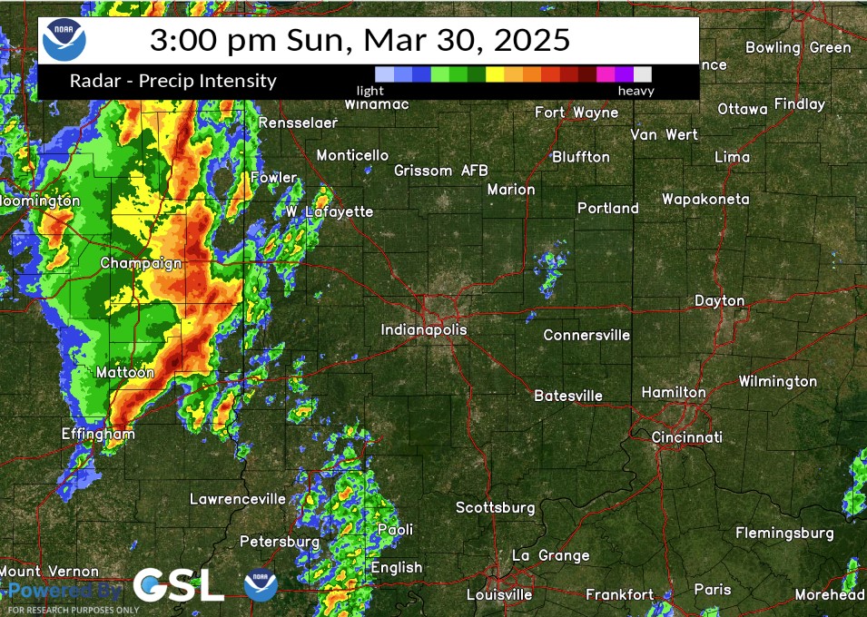
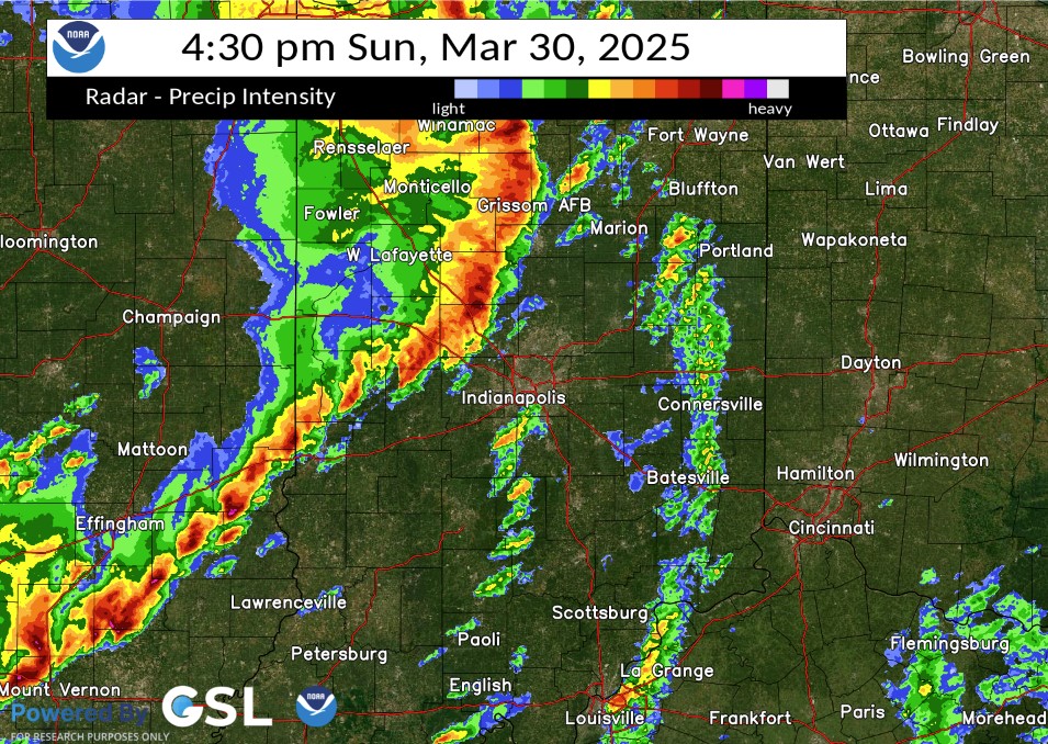
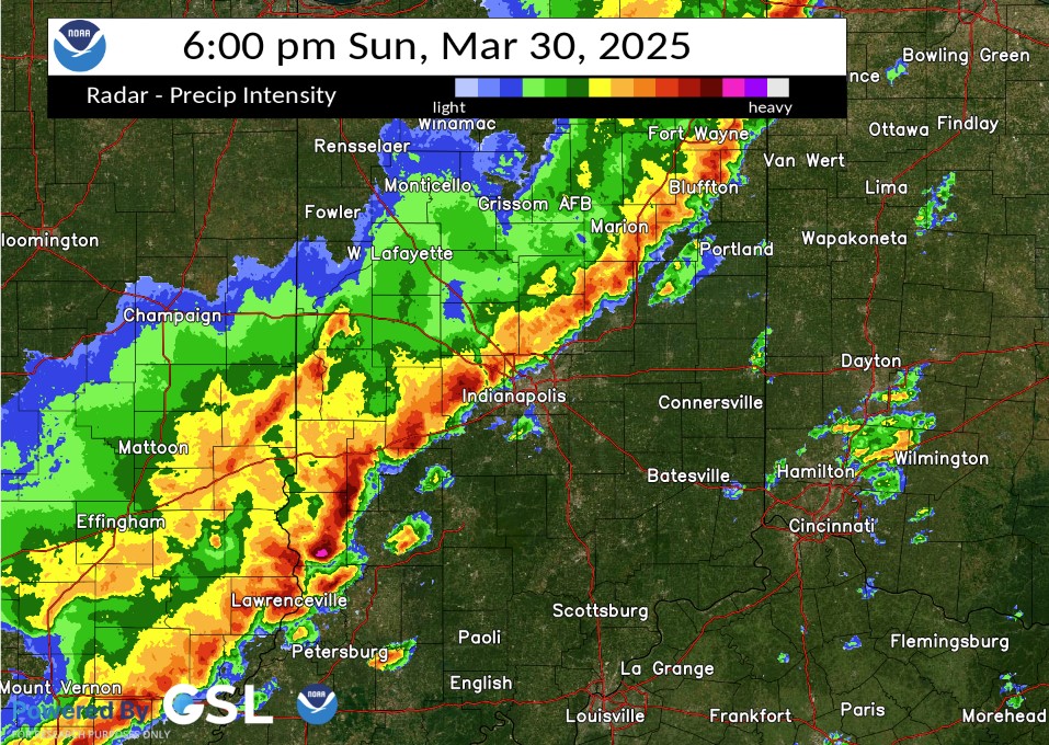
Below are selected images from the event. A loop of the event is available.
 |
 |
 |
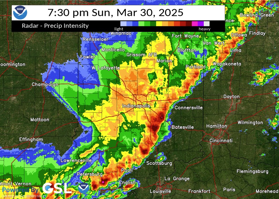 |
| Radar at 3:00 PM EDT | Radar at 4:30 PM EDT | Radar at 6:00 PM EDT | Radar at 7:30 PM EDT |
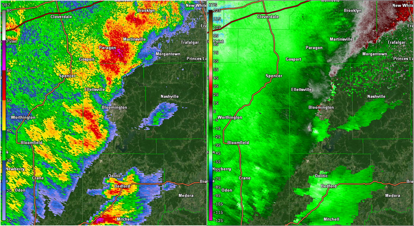
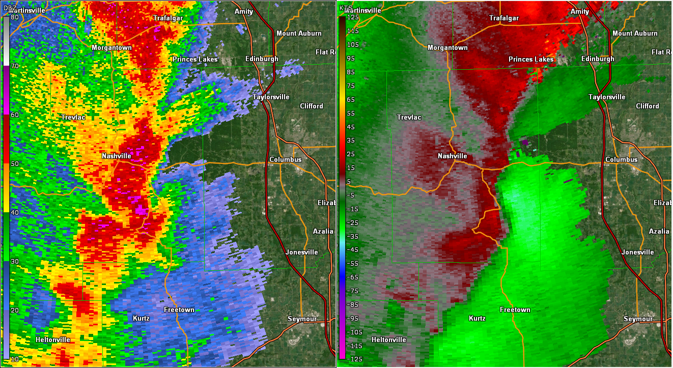
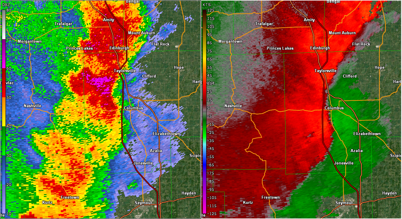
Selected Zoomed in Radar/Velocity Images
 |
 |
 |
|
| Radar/Velocity at 6:43 PM EDT in Monroe County | Radar/Velocity at 7:05 PM EDT in Brown County | Radar/Velocity at 7:17 PM EDT in Bartholomew County | Caption |
Header
| Caption | Caption | Caption | Caption |
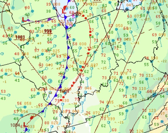
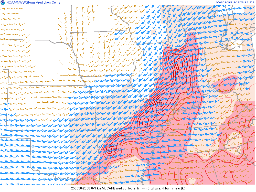
Environment
Insert synoptic summary.
 |
 |
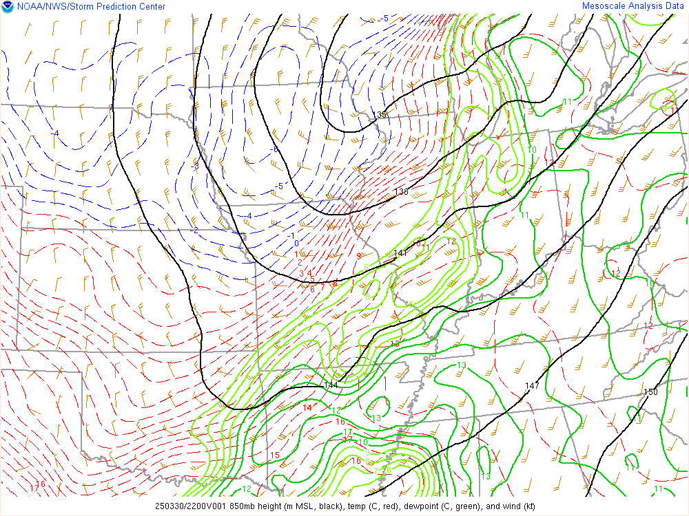 |
| Figure 1: Zoomed-in Surface Map at 5:00 PM EDT | Figure 2: 0-3km CAPE & Shear at 4:00 PM EDT | Figure 3: 850mb Analysis at 6:00 PM EDT |
 |
Media use of NWS Web News Stories is encouraged! Please acknowledge the NWS as the source of any news information accessed from this site. |
|

