Overview
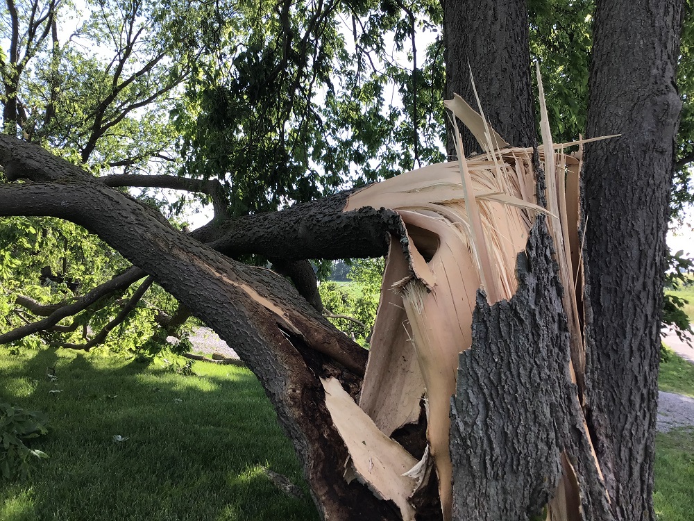
A low pressure system moved through central Indiana during the afternoon of June 8, bringing tornadoes, damaging winds, and large hail to the area.Tornadoes
|
Tornado - Near Arlington
Track Map  
|
||||||||||||||||
|
||||||||||||||||
|
Tornado - Summitville
Track Map 
|
||||||||||||||||
|
||||||||||||||||
The Enhanced Fujita (EF) Scale classifies tornadoes into the following categories:
| EF0 Weak 65-85 mph |
EF1 Moderate 86-110 mph |
EF2 Significant 111-135 mph |
EF3 Severe 136-165 mph |
EF4 Extreme 166-200 mph |
EF5 Catastrophic 200+ mph |
 |
|||||
Radar
Radar Loop
Storm Reports
PRELIMINARY LOCAL STORM REPORT...SUMMARY...CORRECTED
NATIONAL WEATHER SERVICE INDIANAPOLIS IN
242 PM EDT THU JUN 9 2022

..TIME...   ...EVENT...      ...CITY LOCATION...     ...LAT.LON...
..DATE...   ....MAG....      ..COUNTY LOCATION..ST.. ...SOURCE....
            ..REMARKS..

0408 PM     TORNADO          2 W ARLINGTON           39.64N 85.62W
06/08/2022                   RUSH               IN   NWS STORM SURVEY

            SURVEY CONFIRMED TORNADO FROM 5ESE
            MORRISTOWN TO 3N RUSHVILLE.

0415 PM     TSTM WND DMG     1 W ARLINGTON           39.64N 85.59W
06/08/2022                   RUSH               IN   FIRE DEPT/RESCUE

            DAMAGE AT POSEY TWP VOLUNTEER FIRE DEPT
            REPORTED BY FIRST RESPONDERS. TORNADO
            POSSIBLE.

0415 PM     TSTM WND DMG     2 W ARLINGTON           39.64N 85.62W
06/08/2022                   RUSH               IN   PUBLIC

            WIND DAMAGE TO TREES AT 9100 BLOCK. TORNADO
            POSSIBLE.

0415 PM     TSTM WND DMG     2 W ARLINGTON           39.64N 85.61W
06/08/2022                   RUSH               IN   LAW ENFORCEMENT

            CORRECTS PREVIOUS TSTM WND DMG REPORT FROM 2
            W ARLINGTON. LAW ENFORCEMENT REPORTS DAMAGE
            TO A RESIDENCE. TORNADO POSSIBLE.

0613 PM     TORNADO          SUMMITVILLE             40.34N 85.65W
06/08/2022                   MADISON            IN   NWS STORM SURVEY

            SURVEY CONFIRMED TORNADO ON THE GROUND FOR
            0.57MI IN SUMMITVILLE, IN.

0215 PM     HAIL             2 N HAYDEN              39.00N 85.74W
06/08/2022  M1.75 INCH       JENNINGS           IN   PUBLIC

            THUNDERSTORM PRODUCED GOLF BALL SIZED HAIL
            IN HAYDEN. TIME ESTIMATED FROM RADAR.

0225 PM     HAIL             NORTH VERNON            39.01N 85.63W
06/08/2022  E1.75 INCH       JENNINGS           IN   PUBLIC

            THUNDERSTORM PRODUCED GOLF BALL SIZED HAIL.
            TIME ESTIMATED FROM RADAR.

0234 PM     HAIL             3 SW COUNTRY SQUIRE LAK 39.02N 85.72W
06/08/2022  E0.70 INCH       JENNINGS           IN   PUBLIC

            THUNDERSTORM PRODUCED DIME SIZED HAIL.

0228 PM     TSTM WND DMG     2 NNE MOORESVILLE       39.65N 86.35W
06/08/2022                   HENDRICKS          IN   LAW ENFORCEMENT

            DELAYED REPORT. LARGE TREE LIMB BLOCKING
            EAST BOUND 800S WEST OF SR 67. TIME
            ESTIMATED FROM RADAR.

0405 PM     TSTM WND DMG     1 NNW STONE HEAD        39.15N 86.17W
06/08/2022                   BROWN              IN   911 CALL CENTER

            LATE REPORT OF 3 TREES DOWNED BY
            THUNDERSTORM WINDS ON INDIANA ROUTE 135.

0410 PM     TSTM WND DMG     3 ENE SPURGEONS CORNER  39.09N 86.10W
06/08/2022                   BROWN              IN   911 CALL CENTER

            LATE REPORT OF 2 TREES DOWNED BY
            THUNDERSTORM WINDS. ONE TREE DOWNED AT EACH
            END OF GARRITY ROAD. TIME ESTIMATED FROM
            RADAR.


&&

$$
Environment
A low pressure system moved across central Indiana. Thunderstorms developed in an unstable environment with plenty of shear.
 |
 |
| Figure 1: Surface Map at 5:00 PM EDT | Figure 2: 500mb at 4:00 PM EDT |
 |
 |
 |
| Figure 3: Mixed Layer CAPE at 4:00 PM EDT | Figure 5: Effective Shear at 4:00 PM EDT | Figure 6: Supercell Parameter at 4:00 PM EDT |
 |
Media use of NWS Web News Stories is encouraged! Please acknowledge the NWS as the source of any news information accessed from this site. |
|