Overview
A complex of thunderstorms produced damaging wind in a swath from southern Montgomery county and northern Putnam county through the Interstate 74 corridor into Ohio before gradually weakening as it moved into northern Kentucky and West Virginia. The peak measured wind gust was 68 mph at the Crawfordsville AWOS with pockets of higher end damage across far southeastern Marion county and far northwestern Shelby county. Later in the evening, a rogue thunderstorm along the front produced a landspout that moved from Illinois into Warren county causing no damage.
Landspout
|
Landspout - Warren County, IN
Track Map 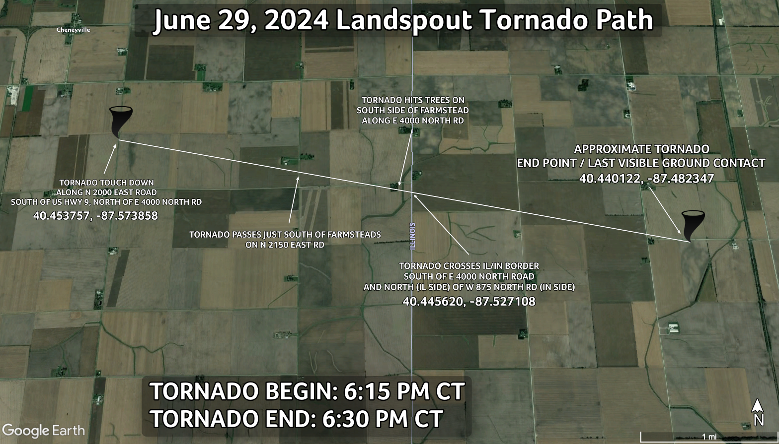 
|
||||||||||||||||
The Enhanced Fujita (EF) Scale classifies tornadoes into the following categories:
| EF0 Weak 65-85 mph |
EF1 Moderate 86-110 mph |
EF2 Significant 111-135 mph |
EF3 Severe 136-165 mph |
EF4 Extreme 166-200 mph |
EF5 Catastrophic 200+ mph |
 |
|||||
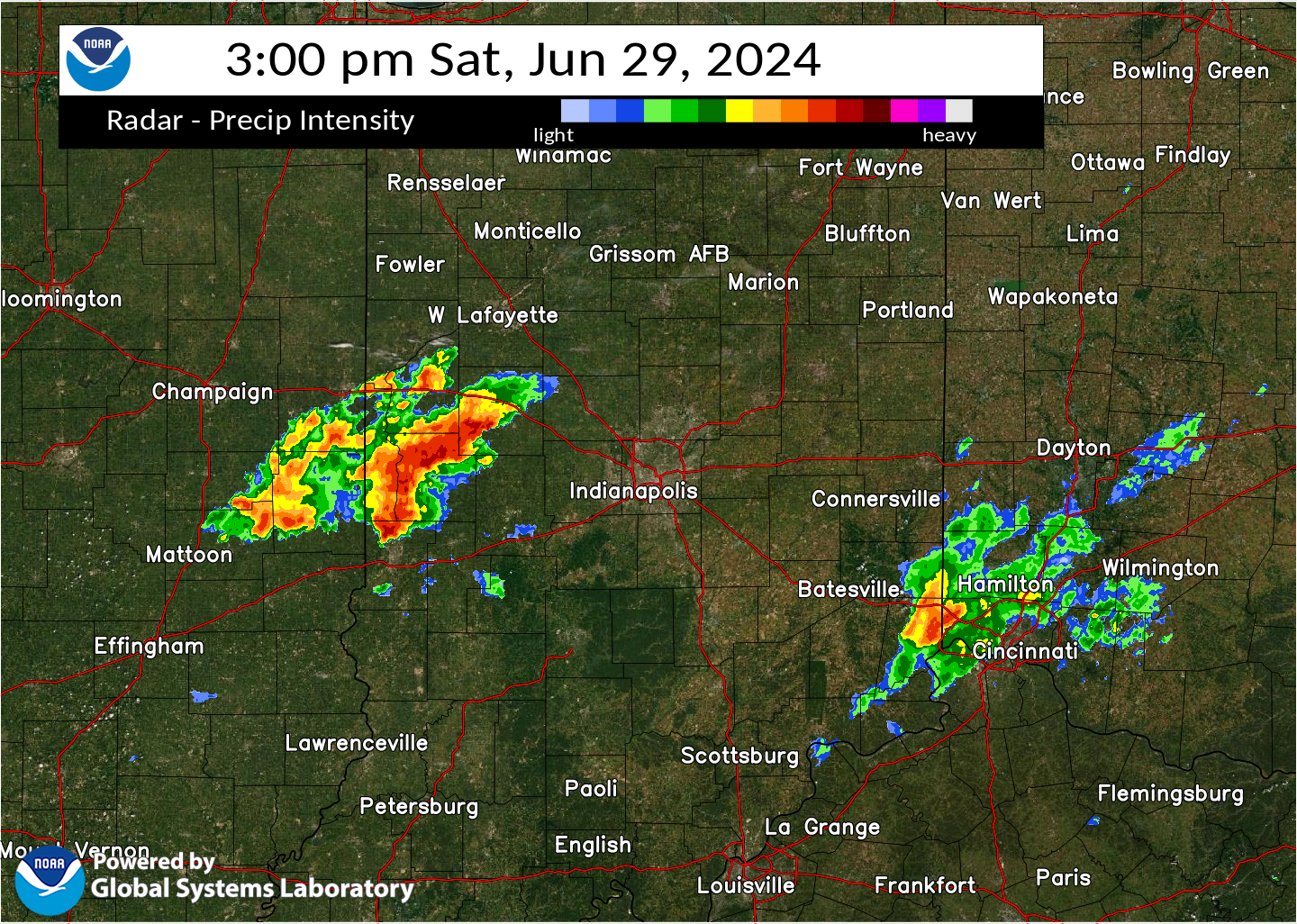
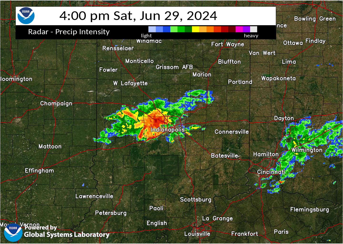
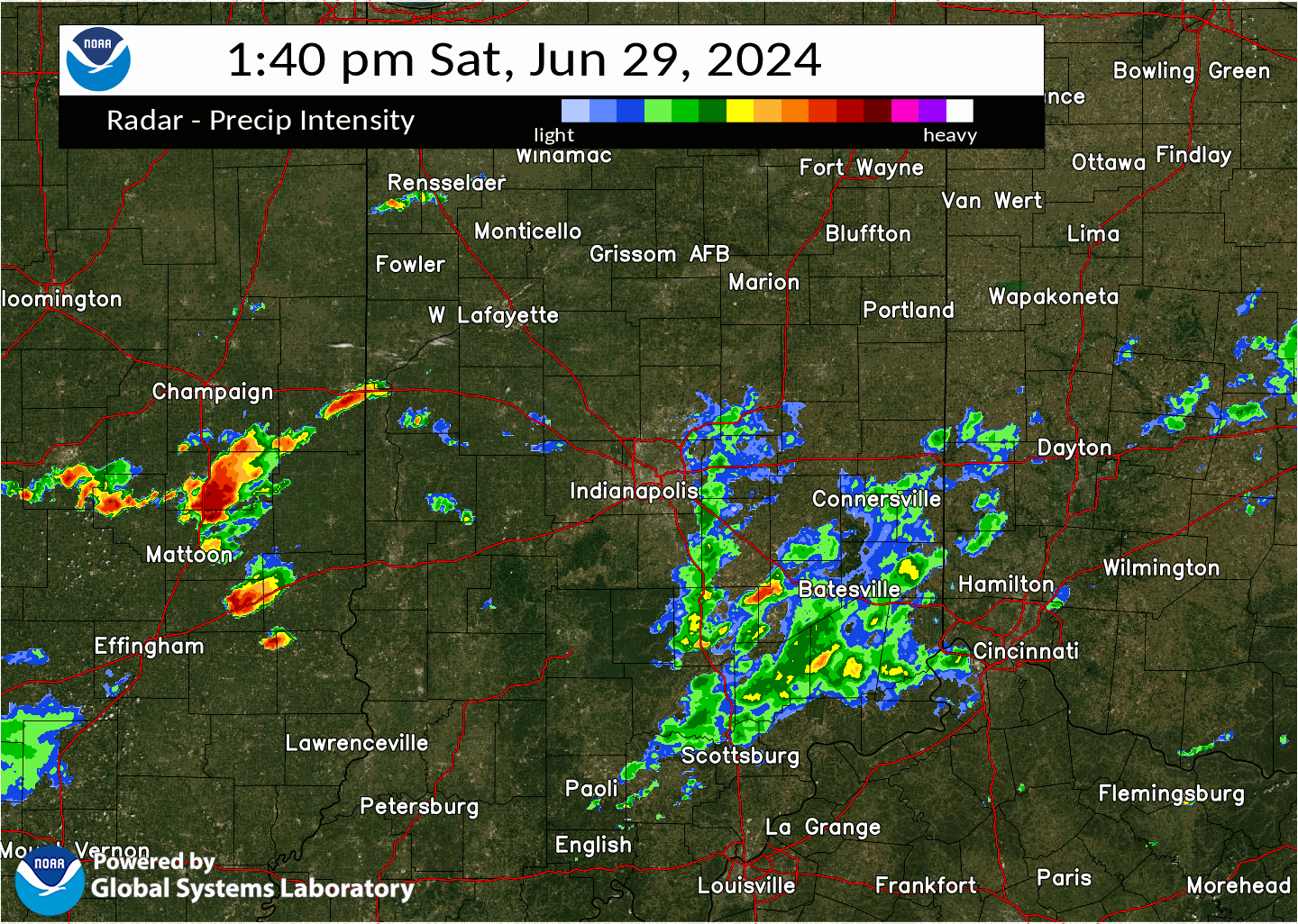
Radar
Selected images from the event are below. A loop of radar from the event follows the images below.
 |
 |
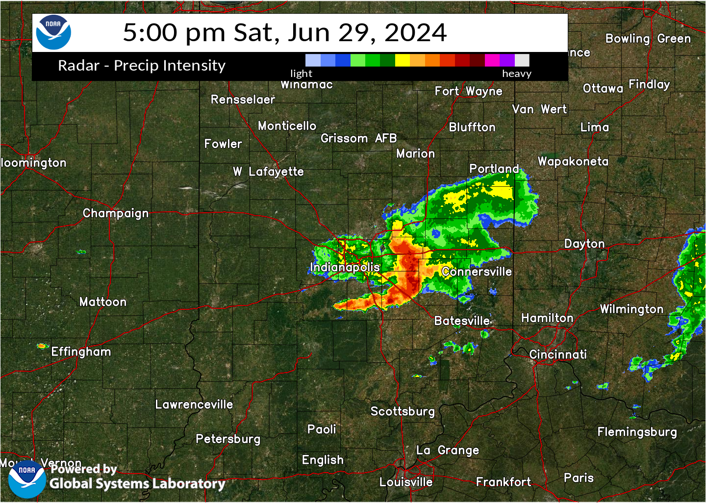 |
| Radar at 3:00 PM EDT | Radar at 4:00 PM EDT | Radar at 5:00 PM EDT |
 |
| A loop of the radar showing the evolution of the storm |
Storm Reports
Preliminary Local Storm Report...Summary
National Weather Service Indianapolis IN
311 PM EDT Sun Jun 30 2024

..TIME...   ...EVENT...      ...CITY LOCATION...     ...LAT.LON...
..DATE...   ....MAG....      ..COUNTY LOCATION..ST.. ...SOURCE....
            ..REMARKS..

0315 PM     Tstm Wnd Gst     2 N New Market          39.98N 86.92W
06/29/2024  M68 MPH          Montgomery         IN   AWOS

            AWOS station KCFJ Crawfordsville.

0320 PM     Tstm Wnd Dmg     2 S Waveland            39.85N 87.05W
06/29/2024                   Parke              IN   911 Call Center

            Several reports of trees down across the
            northeastern portions of the county. Time
            estimated from radar.

0347 PM     Tstm Wnd Dmg     3 SW Danville           39.73N 86.56W
06/29/2024                   Hendricks          IN   Public

            Power lines downed.

0349 PM     Tstm Wnd Dmg     3 WSW Stilesville       39.62N 86.68W
06/29/2024                   Putnam             IN   911 Call Center

            Trees down blocking both westbound lanes of
            US40. Time estimated from radar.

0351 PM     Tstm Wnd Dmg     1 NE Danville           39.77N 86.51W
06/29/2024                   Hendricks          IN   Trained Spotter

            Three trees about 6 inches in diameter
            across the road, time estimated from radar.

0356 PM     Tstm Wnd Dmg     1 WNW Plainfield        39.70N 86.41W
06/29/2024                   Hendricks          IN   Public

            Large maple tree limb snapped. Time
            estimated from radar.

0422 PM     Tstm Wnd Dmg     3 SSE Beech Grove       39.68N 86.07W
06/29/2024                   Marion             IN   Public

            Numerous trees downed with roof damage also
            noted in a localized area near Edgewood and
            Emerson. Time estimated from radar.

0422 PM     Tstm Wnd Dmg     1 N Beech Grove         39.72N 86.09W
06/29/2024                   Marion             IN   Public

            Several large trees downed across Beech
            Grove. Time estimated from radar.

0432 PM     Tstm Wnd Dmg     5 SW New Palestine      39.67N 85.95W
06/29/2024                   Marion             IN   Emergency Mngr

            Several large and mature trees snapped or
            uprooted with power pole damage also noted.
            Time estimated from radar.

0454 PM     Tstm Wnd Dmg     1 E Morristown          39.67N 85.69W
06/29/2024                   Shelby             IN   Public

            Tree down across US52 near Morristown. Power
            out across town. Time estimated from radar.

0515 PM     Tstm Wnd Dmg     1 SSE Knightstown       39.78N 85.52W
06/29/2024                   Rush               IN   Emergency Mngr

            Large tree downed. Time estimated from
            radar.

0520 PM     Tstm Wnd Dmg     1 W Mays                39.74N 85.46W
06/29/2024                   Rush               IN   Emergency Mngr

            Large trees down. Time estimated from radar.

0732 PM     Landspout        2 E Tab                 40.41N 87.43W
06/29/2024                   Warren             IN   Trained Spotter

            Approximate end location of a landspout that
            began in far eastern Illinois. Photo
            received via social media.
Environment
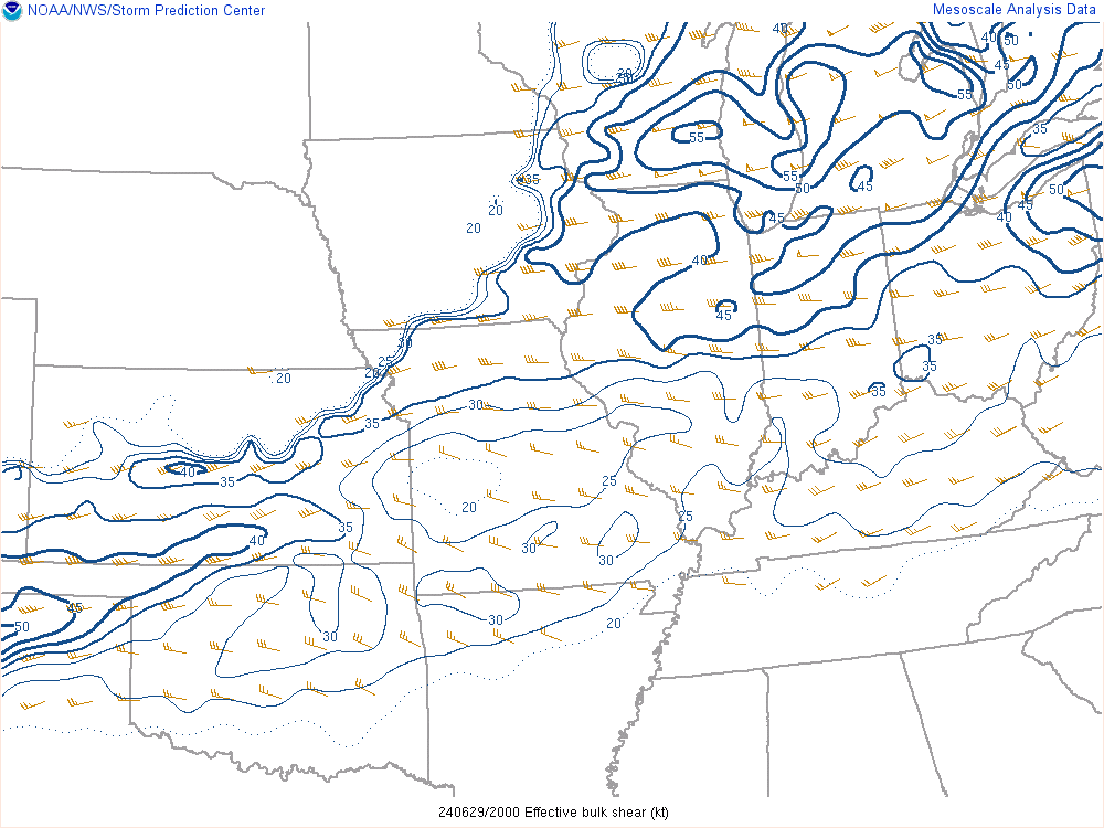
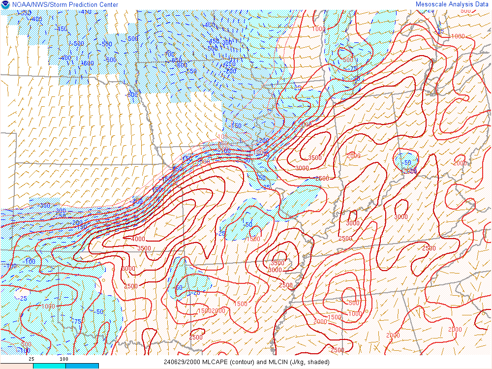
Thunderstorms began shortly after 2 PM with a marginal CAPE and shear environment during the course of the storms. The biggest hinderance to the mixing down of the very strong rear inflow jet winds was the low level lapse rates being less than moist adiabatic. Had the lapse rates been a bit higher, this system would likely have produced much more widespread 60-80 mph winds based on the strength of the cold pool.
 |
 |
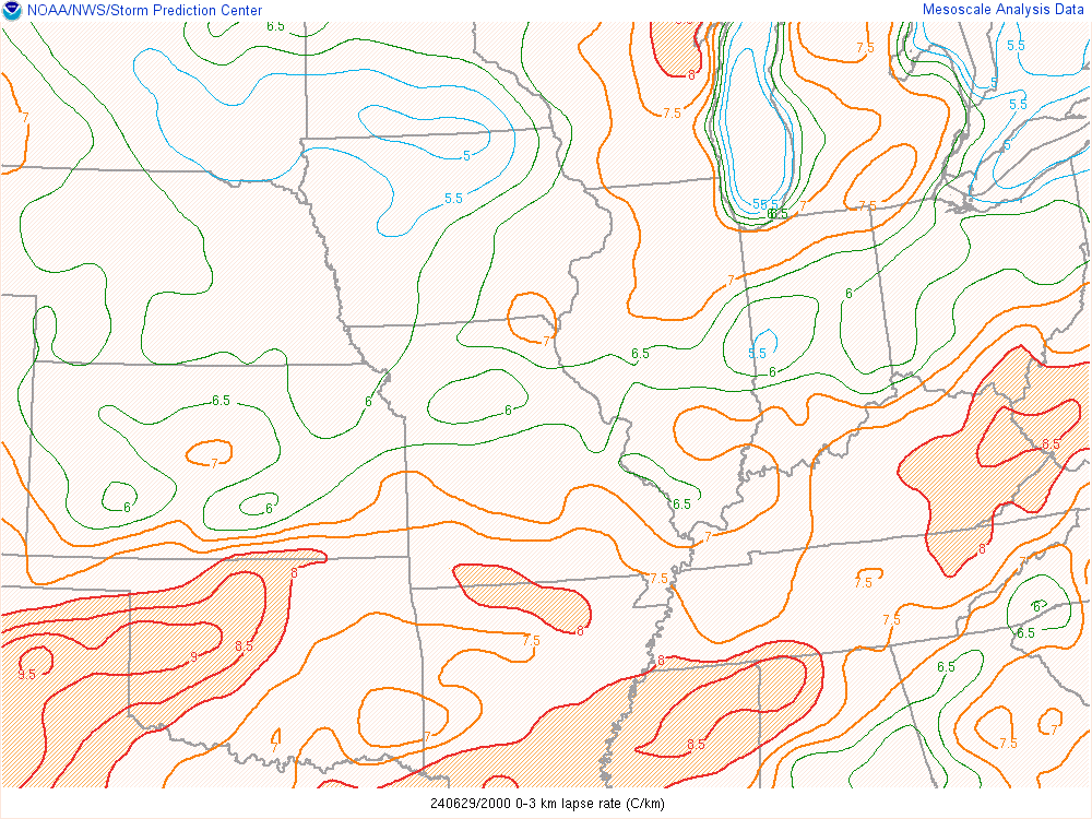 |
| Figure 1: Bulk Shear at 4:00 PM EDT | Figure 2: Mixed Layer CAPE at 4:00 PM EDT | Figure 3: 0-3km Lapse Rate at 4:00 PM EDT |
The intersection of the outflow boundary created by the earlier thunderstorms and the arriving front created a narrow window with a higher Enhanced Stretching Potential parameter as seen in figure 4 below. This favorable environment produced a weak landspout that caused no damage across Warren county.
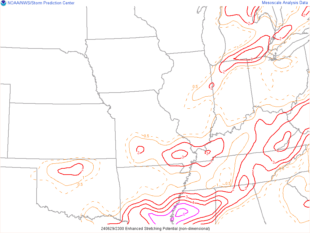 |
| Figure 4: Enhanced Stretching Potential Parameter at 8:00 PM EDT |
 |
Media use of NWS Web News Stories is encouraged! Please acknowledge the NWS as the source of any news information accessed from this site. |
|

